1980s Maps of Orienta, Wisconsin
Explore 5 historic maps of Orienta from the 1980s. These maps offer a rare glimpse into what life looked like during the 1980s — showing old roads, neighborhoods, homes, and landmarks that have changed or disappeared over time.
Whether you're researching your family's past, planning a metal detecting trip, or studying how Orienta's landscape evolved across the 1980s, these high-resolution maps are a powerful tool for exploring the history of this region.
- Focus on a specific era: All maps on this page are from the 1980s, giving you a focused view of this time period.
- See what’s changed: Compare century-old streets, trails, and buildings to today's modern landscape using overlays and satellite layers.
- Research with precision: Use these maps for genealogy, historical research, land use analysis, or educational projects.
- View, download, or print: Maps are fully viewable online in high resolution, and can be downloaded or printed for your own records.
Start exploring Orienta's history through authentic maps from the 1980s. This is your window into the past.
Orienta, WI maps
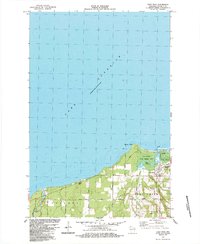
(5)- 1980 Map of Port Wing
 1980 Port Wing1980 Print · USGSThe Lake Superior shoreline and the deep forests of Bayfield and Douglas counties are captured here in the early eighties. Genealogists and historians can trace the rail lines through Iron River or locate the lakeside landings at Cornucopia and Port Wing.
 - 1984 Map of Iron Lake NE
 1984 Iron Lake NE1984 Print · USGSBayfield County's timber and water resources are mapped here in the mid-1980s during a period of forest management and conservation. Genealogists and local historians can trace family land via Larson Road or locate the National Fish Hatchery and Lenawee settlement.
 - 1984 Map of Oulu
 1984 Oulu1984 Print · USGSCoastal Douglas and Bayfield Counties meet the shore of Lake Superior here in the mid-1980s. Local researchers can trace family sites near Waino and Oulu, or locate landmarks along the famous Bois Brule River like Shale Falls and McNeil Landing.
 - 1984 Map of Blaine Creek
 1984 Blaine Creek1984 Print · USGSBayfield County's rural townships are shown in the mid-1980s, centered on the winding Iron River and its many tributaries. Genealogists can trace family footprints along Severson Road and Mannik Road, or locate the Hillside Cem and the Orienta Dam.
 - 1984 Map of Port Wing
 1984 Port Wing1984 Print · USGSAlong the shores of Lake Superior in the early 1980s, this area shows the fishing and timber country surrounding Port Wing. Researchers can locate family landmarks like Greenwood Cem and trace the paths of the Flag River and Iron River.
End of results
Showing maps 1-5 of 5
Top cities near Orienta
Frequently asked questions
- What are the different types of historical maps available for Orienta?
- What is the oldest map of Orienta?
- Where can I purchase historical maps of Orienta for my home or office?
- Where can I download high-res historical maps of Orienta?
- Are there historical topographic maps available for Orienta?
- Is there historical aerial imagery available for Orienta?
- Where are historical maps of Orienta sourced from?