1970s Maps of Brown County, Wisconsin
Explore 16 historic maps of Brown County from the 1970s. These maps offer a rare glimpse into what life looked like during the 1970s — showing old roads, neighborhoods, homes, and landmarks that have changed or disappeared over time.
Whether you're researching your family's past, planning a metal detecting trip, or studying how Brown County's landscape evolved across the 1970s, these high-resolution maps are a powerful tool for exploring the history of this region.
- Focus on a specific era: All maps on this page are from the 1970s, giving you a focused view of this time period.
- See what’s changed: Compare century-old streets, trails, and buildings to today's modern landscape using overlays and satellite layers.
- Research with precision: Use these maps for genealogy, historical research, land use analysis, or educational projects.
- View, download, or print: Maps are fully viewable online in high resolution, and can be downloaded or printed for your own records.
Start exploring Brown County's history through authentic maps from the 1970s. This is your window into the past.
Brown County, WI maps
(16)- 1974 Map of Hilbert, 1977 Print
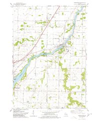
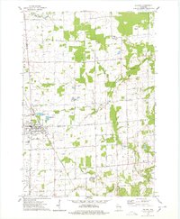
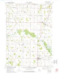 1974 Hilbert1977 Print · USGSCalumet County was a thriving rail intersection in the 1970s, where three major lines converged at the village of Hilbert. Genealogists and local historians can trace the community's heritage through landmarks like St Peters Cem, Forest Junction, and the Forest Assembly Ground.
 - 1974 Map of Brillion, 1977 Print
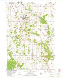
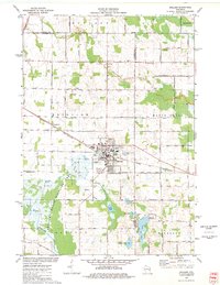 1974 Brillion1977 Print · USGSBrillion and its neighboring townships are captured in the mid-seventies during a period of steady industrial and agricultural activity. Researchers can trace family-named roads and rural burial grounds like Evergreen Cem, St Marys Cem, and the Chicago and North Western rail line.
 - 1974 Map of Zachow, 1977 Print
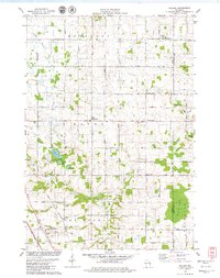
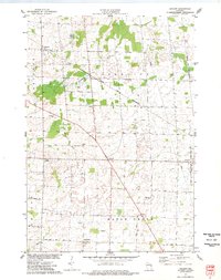 1974 Zachow1977 Print · USGSEastern Wisconsin farmland and crossroads villages are captured here in the mid-1970s, as the Chicago and North Western railroad still served the region. Researchers can trace rural church and cemetery sites such as Zion Ch, St Pauls Ch, and Resthaven Cem.
 - 1974 Map of Greenleaf, 1978 Print
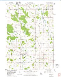
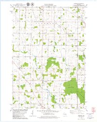
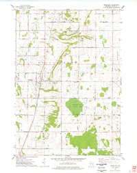 1974 Greenleaf1978 Print · USGSCentral Brown County in the mid-seventies reveals a landscape defined by the East River and the rural crossroads of Greenleaf. Genealogists and historians can trace old family roads, St Marys Sch, and the grounds of the Holland State Wildlife Area.
 - 1974 Map of Oneida South, 1978 Print
 1974 Oneida South1978 Print · USGSThe Oneida Indian Reservation and the banks of the Fox River are captured here during the mid-seventies. Researchers can trace ancestral locations and local landmarks from Little Rapids to the Immaculate Conception Sch and Lost Dauphin State Park.
 - 1974 Map of Wrightstown, 1978 Print
 1974 Wrightstown1978 Print · USGSWrightstown and the Fox River valley are captured in the mid-1970s, showing a landscape defined by water power and rural crossroads. Genealogists can locate numerous local burial sites like St Johns Cem and South Lawrence Cem, or trace the old Chicago and Northwestern rail corridor.
 - 1974 Map of Little Tail Point, 1978 Print
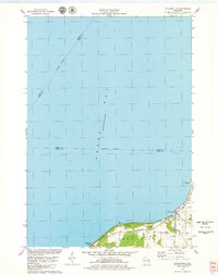
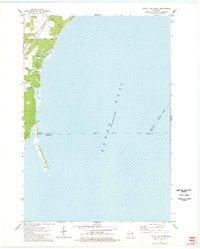 1974 Little Tail Point1978 Print · USGSThe Oconto County shoreline in the mid-seventies is defined by the narrow spit of Little Tail Point and the adjacent wetlands. Genealogists and historians can trace the Chicago and North Western rail corridor and early access roads at Lade Beach.
 - 1974 Map of Oneida North, 1978 Print
 1974 Oneida North1978 Print · USGSBrown and Outagamie counties in the mid-seventies reveal a network of rural hamlets and farming townships. Genealogists can trace family footprints through sites like Owego Cem, Lannoye Sch, and the historical community at Oneida.
 - 1974 Map of Suamico, 1978 Print
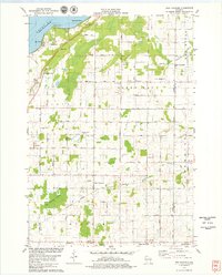
 1974 Suamico1978 Print · USGSCoastal Wisconsin settlements like Little Suamico and Sobieski are shown here as they appeared in the mid-seventies before significant modern expansion. Genealogists can trace family landmarks such as St Benedict Cem, Riverside Cem, and the old rail lines of the Chicago and North Western.
 - 1974 Map of Pulaski, 1978 Print
 1974 Pulaski1978 Print · USGSNear the intersection of three counties in the mid-1970s, the village of Pulaski is shown alongside its rail and religious roots. Genealogists can locate family sites at the Franciscan Monastery, St Joseph Cem, and Polish National Cem.
 - 1978 Map of Denmark, 1979 Print
 1978 Denmark1979 Print · USGSBrown County and Manitowoc County crossroads come alive in the late seventies, showing the transition from village centers to protected forest lands. Genealogists can locate family names at West Danish Cem or trace the early paths of Denmark and Maribel.
 - 1978 Map of Poland, 1979 Print
 1978 Poland1979 Print · USGSThe rural borderlands of Brown and Kewaunee counties are captured here in the late seventies. Researchers can locate family-named landmarks like Coppens Corner, trace the Chicago and North Western rail line, or find local burial records at St Josephs Cem.2 unique versions available
 - 1978 Map of Reedsville, 1979 Print
 1978 Reedsville1979 Print · USGSManitowoc County agriculture and industry are captured here in the late seventies, centered on the rail-served village of Reedsville. Genealogists and local historians can trace family church and burial sites like Zion Evergreen Cem and search for old schoolhouses such as Wayside Sch.
 - 1978 Map of Dyckesville, 1979 Print
 1978 Dyckesville1979 Print · USGSCoastal life along Green Bay in the late seventies reveals a landscape of lakeside retreats and rural crossroads. Local historians can trace the development of Dyckesville and Edgewater Beach, or locate landmarks like Dyckes Falls and Barretts Point.
 - 1978 Map of Morrison, 1979 Print
 1978 Morrison1979 Print · USGSSouthern Brown County's rural townships are captured here in the late seventies, showing a landscape of dairy farms and crossroads settlements. Researchers can locate historic community centers like Morrison and Wayside alongside Zion Cem and Immanuel Sch.
 - 1978 Map of New Franken, 1979 Print
 1978 New Franken1979 Print · USGSThe eastern shore of Green Bay and the rural townships of Brown County come alive in this late-seventies survey. Genealogists and historians can trace family-named sites like St Kilian Ch, the Humboldt Cem, and the path of the Green Bay and Western rail line.2 unique versions available
End of results
Showing maps 1-16 of 16
Top cities of Brown County
- Green Bay historical maps
- De Pere historical maps
- Howard historical maps
- Allouez historical maps
- Bellevue historical maps
- Suamico historical maps
See more
Frequently asked questions
- What are the different types of historical maps available for Brown County?
- What is the oldest map of Brown County?
- Where can I purchase historical maps of Brown County for my home or office?
- Where can I download high-res historical maps of Brown County?
- Are there historical topographic maps available for Brown County?
- Is there historical aerial imagery available for Brown County?
- Where are historical maps of Brown County sourced from?