
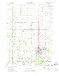
1974 Map of Hilbert
USGS Topo · Published 1977About this map
The village of Hilbert serves as a central hub for three intersecting rail systems in the mid-1970s, including the Soo Line, Chicago and North Western, and Chicago Milwaukee St Paul and Pacific. This rail-dominated landscape is dotted with small agricultural settlements like St John and Dundas, which are connected by a grid of rural routes such as Schmidt Road and Harvestore Road. The presence of the Forest Assembly Ground and multiple religious sites, including St John Ch and St Marys Cem, indicates a deeply rooted community structure in rural Calumet County.
Find a feature on this map
43 named features on this map. Tap any name to fly to it.
Don’t see what you’re looking for? This feature index may not catch every label — zoom into the map to look around manually.
Map Details
Editions of this 1974 Hilbert Map
This is the sole edition of this map. No revisions or reprints were ever made.
Other maps of this area

1911 · Neenah
USGS Topo · 1:62,500

1954 · De Pere
USGS Topo · 1:62,500

1954 · Chilton
USGS Topo · 1:62,500

1955 · Neenah
USGS Topo · 1:62,500

1955 · Appleton
USGS Topo · 1:62,500

1955 · Green Bay
USGS Topo · 1:250,000

1974 · Brillion
USGS Topo · 1:24,000
1974 · Chilton
USGS Topo · 1:24,000
1974 · Potter
USGS Topo · 1:24,000
1974 · Stockbridge
USGS Topo · 1:24,000