1980s Maps of Brown County, Wisconsin
Explore 8 historic maps of Brown County from the 1980s. These maps offer a rare glimpse into what life looked like during the 1980s — showing old roads, neighborhoods, homes, and landmarks that have changed or disappeared over time.
Whether you're researching your family's past, planning a metal detecting trip, or studying how Brown County's landscape evolved across the 1980s, these high-resolution maps are a powerful tool for exploring the history of this region.
- Focus on a specific era: All maps on this page are from the 1980s, giving you a focused view of this time period.
- See what’s changed: Compare century-old streets, trails, and buildings to today's modern landscape using overlays and satellite layers.
- Research with precision: Use these maps for genealogy, historical research, land use analysis, or educational projects.
- View, download, or print: Maps are fully viewable online in high resolution, and can be downloaded or printed for your own records.
Start exploring Brown County's history through authentic maps from the 1980s. This is your window into the past.
Brown County, WI maps
(8)- 1982 Map of De Pere
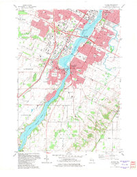 1982 De Pere1982 Print · USGSDe Pere and the Fox River corridor are captured here in the early eighties as the region balanced its industrial roots with suburban growth. Researchers can trace institutional landmarks like St Norbert College or the legacy of rail at the National Railroad Museum.
 - 1982 Map of Green Bay East
 1982 Green Bay East1982 Print · USGSGreen Bay and its eastern suburbs are shown during a period of significant regional growth in the early eighties. Genealogists and local historians can locate specific landmarks such as Holy Cross Church, the abandoned lighthouse at Long Tail Point, and Haevers Corners.
 - 1982 Map of Bellevue
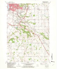 1982 Bellevue1982 Print · USGSBrown County’s landscape in the early eighties shows the suburban growth of Green Bay meeting the rural traditions of Glenmore. Researchers can trace old family lands near Langes Corners, Bellevue Cem, and the Chicago and North Western rail line.
 - 1982 Map of Green Bay West, 1983 Print
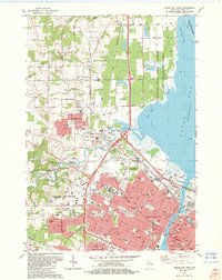 1982 Green Bay West1983 Print · USGSThe Fox River waterfront and Green Bay's western suburbs are captured here during a period of significant growth. Genealogists and historians can trace neighborhood development near Fort Howard Cemetery or locate local landmarks like Lambeau Field and Plainview Landing Strip.
 - 1984 Map of Sturgeon Bay, 1985 Print
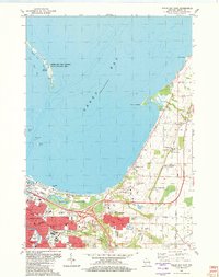
 1984 Sturgeon Bay1985 Print · USGSDoor Peninsula and the Kewaunee coast are documented here in the mid-eighties, showing the deep-water harbor at Sturgeon Bay and the rural agricultural interior. Genealogists can trace family roots through crossroads towns like Kolberg, Duvall, and Sugar Bush.2 unique versions available
 - 1984 Map of Appleton, 1985 Print
 1984 Appleton1985 Print · USGSThe Fox River Valley in the mid-eighties shows a bustling corridor of industry and nature, from the shores of Lake Winnebago to the Oneida Indian Reservation. Trace local heritage through landmarks like Riverside Cem or explore the wetlands of Poygan Marsh State Wildlife Area.2 unique versions available
 - 1984 Map of Manitowoc, 1985 Print
 1984 Manitowoc1985 Print · USGSThe Lake Michigan shoreline of eastern Wisconsin is captured here in the mid-eighties, showing the bustling ports and rail-fed industry of the era. Genealogists and researchers can trace family-named sites near Stangelville, find the Francis Creek National Cem, or locate the U S Coast Guard Station.2 unique versions available
 - 1984 Map of Shawano, 1985 Print
 1984 Shawano1985 Print · USGSNortheast Wisconsin in the mid-1980s was a landscape defined by its indigenous heritage and the bustling trade centers of the Fox and Wolf River valleys. Genealogists and historians can trace rail corridors like the Chicago and North Western or locate family sites near Keshena, Cecil, and the Fort Howard Cem.2 unique versions available
End of results
Showing maps 1-8 of 8
Top cities of Brown County
- Green Bay historical maps
- De Pere historical maps
- Howard historical maps
- Allouez historical maps
- Bellevue historical maps
- Suamico historical maps
See more
Frequently asked questions
- What are the different types of historical maps available for Brown County?
- What is the oldest map of Brown County?
- Where can I purchase historical maps of Brown County for my home or office?
- Where can I download high-res historical maps of Brown County?
- Are there historical topographic maps available for Brown County?
- Is there historical aerial imagery available for Brown County?
- Where are historical maps of Brown County sourced from?