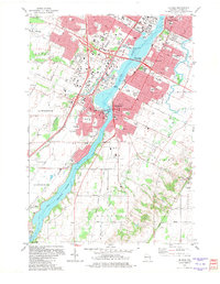
1982 Map of De Pere
USGS Topo · Published 1982About this map
The Fox River serves as the industrial and cultural spine of this 1982 survey, anchoring the development of De Pere and Allouez. The map captures a sophisticated riverfront landscape where institutional history meets modern infrastructure, evidenced by the riverside presence of St Norbert College, the St Norbert Abby, and Heritage Hill State Park. To the west, the expansion of Austin-Straubel Field and the Oneida Ind Res Bdy contrast with the dense residential grids of Ashwaubenon. Southward, the landscape transitions toward the rural reaches of Rockland and Glenmore, while the Chicago and North Western tracks parallel the waterway. This record provides a detailed look at the region's navigation history, from the De Pere Dam and its associated Lock to the Little Kaukauna Lock and Dam downstream near Little Rapids.
Find a feature on this map
91 named features on this map. Tap any name to fly to it.
Don’t see what you’re looking for? This feature index may not catch every label — zoom into the map to look around manually.
Map Details
Editions of this 1982 De Pere Map
This is the sole edition of this map. No revisions or reprints were ever made.
Other maps of this area

1954 · De Pere
USGS Topo · 1:62,500

1954 · Green Bay West
USGS Topo · 1:24,000

1954 · Denmark
USGS Topo · 1:62,500

1954 · De Pere
USGS Topo · 1:24,000

1954 · New Franken
USGS Topo · 1:62,500

1954 · Green Bay East
USGS Topo · 1:24,000

1954 · Manitowoc
USGS Topo · 1:250,000

1954 · Bellevue
USGS Topo · 1:24,000

1954 · Green Bay
USGS Topo · 1:62,500

1955 · Green Bay
USGS Topo · 1:250,000