1970s Maps of Morrison, Wisconsin
Explore 4 historic maps of Morrison from the 1970s. These maps offer a rare glimpse into what life looked like during the 1970s — showing old roads, neighborhoods, homes, and landmarks that have changed or disappeared over time.
Whether you're researching your family's past, planning a metal detecting trip, or studying how Morrison's landscape evolved across the 1970s, these high-resolution maps are a powerful tool for exploring the history of this region.
- Focus on a specific era: All maps on this page are from the 1970s, giving you a focused view of this time period.
- See what’s changed: Compare century-old streets, trails, and buildings to today's modern landscape using overlays and satellite layers.
- Research with precision: Use these maps for genealogy, historical research, land use analysis, or educational projects.
- View, download, or print: Maps are fully viewable online in high resolution, and can be downloaded or printed for your own records.
Start exploring Morrison's history through authentic maps from the 1970s. This is your window into the past.
Morrison, WI maps
(4)- 1974 Map of Brillion, 1977 Print
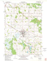 1974 Brillion1977 Print · USGSBrillion and its neighboring townships are captured in the mid-seventies during a period of steady industrial and agricultural activity. Researchers can trace family-named roads and rural burial grounds like Evergreen Cem, St Marys Cem, and the Chicago and North Western rail line.
 - 1974 Map of Greenleaf, 1978 Print
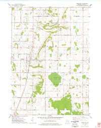 1974 Greenleaf1978 Print · USGSCentral Brown County in the mid-seventies reveals a landscape defined by the East River and the rural crossroads of Greenleaf. Genealogists and historians can trace old family roads, St Marys Sch, and the grounds of the Holland State Wildlife Area.
 - 1978 Map of Reedsville, 1979 Print
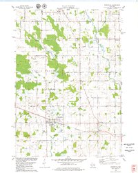 1978 Reedsville1979 Print · USGSManitowoc County agriculture and industry are captured here in the late seventies, centered on the rail-served village of Reedsville. Genealogists and local historians can trace family church and burial sites like Zion Evergreen Cem and search for old schoolhouses such as Wayside Sch.
 - 1978 Map of Morrison, 1979 Print
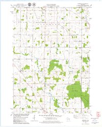 1978 Morrison1979 Print · USGSSouthern Brown County's rural townships are captured here in the late seventies, showing a landscape of dairy farms and crossroads settlements. Researchers can locate historic community centers like Morrison and Wayside alongside Zion Cem and Immanuel Sch.
End of results
Showing maps 1-4 of 4
Top cities near Morrison
- Green Bay historical maps
- Manitowoc historical maps
- De Pere historical maps
- Allouez historical maps
- Bellevue historical maps
- Ledgeview historical maps
See more
Top neighborhoods of Morrison
Frequently asked questions
- What are the different types of historical maps available for Morrison?
- What is the oldest map of Morrison?
- Where can I purchase historical maps of Morrison for my home or office?
- Where can I download high-res historical maps of Morrison?
- Are there historical topographic maps available for Morrison?
- Is there historical aerial imagery available for Morrison?
- Where are historical maps of Morrison sourced from?