1970s Maps of Belvidere, Wisconsin
Explore 4 historic maps of Belvidere from the 1970s. These maps offer a rare glimpse into what life looked like during the 1970s — showing old roads, neighborhoods, homes, and landmarks that have changed or disappeared over time.
Whether you're researching your family's past, planning a metal detecting trip, or studying how Belvidere's landscape evolved across the 1970s, these high-resolution maps are a powerful tool for exploring the history of this region.
- Focus on a specific era: All maps on this page are from the 1970s, giving you a focused view of this time period.
- See what’s changed: Compare century-old streets, trails, and buildings to today's modern landscape using overlays and satellite layers.
- Research with precision: Use these maps for genealogy, historical research, land use analysis, or educational projects.
- View, download, or print: Maps are fully viewable online in high resolution, and can be downloaded or printed for your own records.
Start exploring Belvidere's history through authentic maps from the 1970s. This is your window into the past.
Belvidere, WI maps
(4)- 1972 Map of Cochrane, 1976 Print
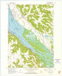 1972 Cochrane1976 Print · USGSThe upper Mississippi riverfront and its surrounding bluffs are captured here in the early seventies, showing a landscape defined by navigation and nature. Genealogists and historians can trace the streets of Cochrane, locate the Mount Vernon Cem, and see the rail lines of the Burlington Northern.2 unique versions available
 - 1972 Map of Weaver, 1976 Print
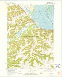 1972 Weaver1976 Print · USGSThe river bluffs and backwaters of Winona County are captured in the early seventies, showing a landscape shaped by timber and the Mississippi. Researchers can trace the tracks of the Chicago Milwaukee St Paul and Pacific and locate local landmarks like St Marys Cem Evergreen Sem or Mount Vernon.2 unique versions available
 - 1974 Map of Alma, 1976 Print
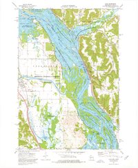 1974 Alma1976 Print · USGSThe Upper Mississippi River corridor is captured here in the mid-1970s, showing the intricate wetlands and industrial river crossings of the border region. You can trace the rail lines of the Burlington Northern and locate sites like Lock and Dam No 4 or the Mill Creek Cem.2 unique versions available
 - 1974 Map of Cream, 1977 Print
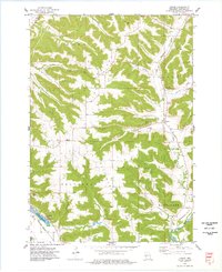 1974 Cream1977 Print · USGSBuffalo County is shown in the mid-1970s as a landscape of deep valleys and prominent ridges tied together by rural family churches. Genealogists can locate several local burial grounds, including Lincoln Cem and Anchorage Cem, alongside the small crossroads of Cream.
End of results
Showing maps 1-4 of 4
Top cities near Belvidere
- Winona historical maps
- Goodview historical maps
- Wabasha historical maps
- Buffalo City historical maps
- Fountain City historical maps
- Alma historical maps
See more
Top neighborhoods of Belvidere
Frequently asked questions
- What are the different types of historical maps available for Belvidere?
- What is the oldest map of Belvidere?
- Where can I purchase historical maps of Belvidere for my home or office?
- Where can I download high-res historical maps of Belvidere?
- Are there historical topographic maps available for Belvidere?
- Is there historical aerial imagery available for Belvidere?
- Where are historical maps of Belvidere sourced from?