1970s Maps of Dover, Wisconsin
Explore 4 historic maps of Dover from the 1970s. These maps offer a rare glimpse into what life looked like during the 1970s — showing old roads, neighborhoods, homes, and landmarks that have changed or disappeared over time.
Whether you're researching your family's past, planning a metal detecting trip, or studying how Dover's landscape evolved across the 1970s, these high-resolution maps are a powerful tool for exploring the history of this region.
- Focus on a specific era: All maps on this page are from the 1970s, giving you a focused view of this time period.
- See what’s changed: Compare century-old streets, trails, and buildings to today's modern landscape using overlays and satellite layers.
- Research with precision: Use these maps for genealogy, historical research, land use analysis, or educational projects.
- View, download, or print: Maps are fully viewable online in high resolution, and can be downloaded or printed for your own records.
Start exploring Dover's history through authentic maps from the 1970s. This is your window into the past.
Dover, WI maps
(4)- 1973 Map of Rossman Creek, 1975 Print
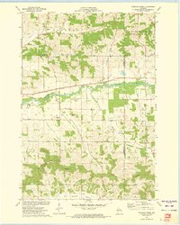 1973 Rossman Creek1975 Print · USGSBuffalo County's rugged coulee country is captured here in the early 1970s as the rail-and-river economy persists along the Buffalo River. Genealogists and local historians can locate the Norden Trinity Ch, the Naples Sch, and family-named terrain like Lindsay Valley.
 - 1973 Map of Mondovi, 1975 Print
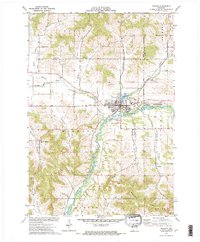 1973 Mondovi1975 Print · USGSBuffalo County is captured here in the early 1970s, centered on the growth of the town of Mondovi and its vital riverfront. Researchers can trace rural lineages through local landmarks like German Valley Ch, Riverside Cem, and the family-named corridors of Thompson Valley.
 - 1973 Map of Lookout, 1975 Print
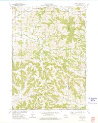 1973 Lookout1975 Print · USGSBuffalo County in the early seventies is a landscape of tight-knit valley communities and high ridges. Genealogists and local historians can trace rural family roots through numerous sites like Lookout Cemetery, Severson Cem, and the prominent Montana Ridge.
 - 1973 Map of Gilmanton, 1975 Print
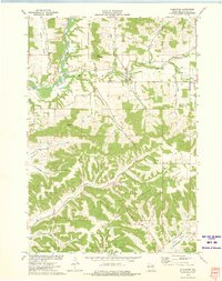 1973 Gilmanton1975 Print · USGSBuffalo County agriculture and topographic relief are on full display in the early 1970s as the town of Gilmanton sits nestled among deep drainage valleys. Researchers can trace family sites near Gilmanton Cem, locate the small settlement of Praag, or follow the winding Buffalo River.
End of results
Showing maps 1-4 of 4
Top cities near Dover
- Arcadia historical maps
- Pleasant Valley historical maps
- Mondovi historical maps
- Whitehall historical maps
- Independence historical maps
- Strum historical maps
See more
Top neighborhoods of Dover
Frequently asked questions
- What are the different types of historical maps available for Dover?
- What is the oldest map of Dover?
- Where can I purchase historical maps of Dover for my home or office?
- Where can I download high-res historical maps of Dover?
- Are there historical topographic maps available for Dover?
- Is there historical aerial imagery available for Dover?
- Where are historical maps of Dover sourced from?