1980s Maps of Daniels, Wisconsin
Explore 5 historic maps of Daniels from the 1980s. These maps offer a rare glimpse into what life looked like during the 1980s — showing old roads, neighborhoods, homes, and landmarks that have changed or disappeared over time.
Whether you're researching your family's past, planning a metal detecting trip, or studying how Daniels's landscape evolved across the 1980s, these high-resolution maps are a powerful tool for exploring the history of this region.
- Focus on a specific era: All maps on this page are from the 1980s, giving you a focused view of this time period.
- See what’s changed: Compare century-old streets, trails, and buildings to today's modern landscape using overlays and satellite layers.
- Research with precision: Use these maps for genealogy, historical research, land use analysis, or educational projects.
- View, download, or print: Maps are fully viewable online in high resolution, and can be downloaded or printed for your own records.
Start exploring Daniels's history through authentic maps from the 1980s. This is your window into the past.
Daniels, WI maps
(5)- 1982 Map of Siren West, 1983 Print
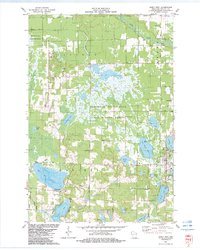 1982 Siren West1983 Print · USGSWisconsin's lakeland region around Siren comes into focus in the early 1980s, showcasing a landscape of conservation and small-town roots. Genealogists and local historians can trace family sites like Chelmo Cem or explore the geography of Big Doctor Lake and the Clam River.
 - 1982 Map of Falun, 1983 Print
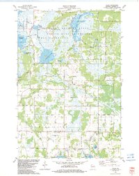 1982 Falun1983 Print · USGSBurnett County in the early eighties was a landscape of managed wetlands and quiet rural crossroads. Genealogists can trace family roots through sites like Anscarius Cem or the namesake Lundquist Road near the settlement of Falun.
 - 1983 Map of Frederic
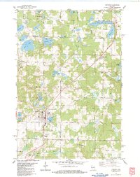 1983 Frederic1983 Print · USGSThe northwestern Wisconsin lake country is captured here in the early eighties, centered on the rail-line communities of Frederic and Lewis. Researchers can trace local genealogy and land use through the Frederic Cem, the Soo Line tracks, and the Fish Hatchery.
 - 1983 Map of Trade Lake
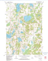 1983 Trade Lake1983 Print · USGSBurnett County and the surrounding lake country are shown here in the early 1980s, revealing a landscape of family-named lakes and rural crossroads. Genealogists and local historians can trace the sites of the Mission Ch, the Union Cem, and small settlements like Atlas and Trade Lake.
 - 1985 Map of Grantsburg
 1985 Grantsburg1985 Print · USGSThe river borderlands of Minnesota and Wisconsin come alive in the mid-1980s, showcasing the intricate water networks and forest preserves of Burnett and Pine counties. Trace the rail lines of the Soo Line or find rural landmarks like Trade Lake Ch and Hildas Corner.2 unique versions available
End of results
Showing maps 1-5 of 5
Top cities near Daniels
- Grantsburg historical maps
- Frederic historical maps
- Luck historical maps
- Trade Lake historical maps
- Siren historical maps
- Webster historical maps
See more
Top neighborhoods of Daniels
Frequently asked questions
- What are the different types of historical maps available for Daniels?
- What is the oldest map of Daniels?
- Where can I purchase historical maps of Daniels for my home or office?
- Where can I download high-res historical maps of Daniels?
- Are there historical topographic maps available for Daniels?
- Is there historical aerial imagery available for Daniels?
- Where are historical maps of Daniels sourced from?