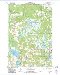
1982 Map of Siren West
USGS Topo · Published 1983About this map
The Clam River meanders through the northeast corner of this glacial landscape, which is defined by an intricate network of wetlands and namesake basins. Large conservation tracts like the Amsterdam Sloughs State Public Hunting Grounds and Crex Meadows State Public Hunting Grounds dominate the central and northwestern sections, reflecting the region's managed wilderness character during the early 1980s. The village of Siren serves as the primary hub, situated near the shores of Crooked Lake and Kapes L. Local history is anchored by several rural burial grounds, including Chelmo Cem and Karlsborg Cem, while the Siren Lookout Tower and Radio Tower stand as prominent landmarks. This era shows a community closely tied to its water resources, with numerous public access points along Mud Hen Lake and Dunham Lake.
Find a feature on this map
47 named features on this map. Tap any name to fly to it.
Don’t see what you’re looking for? This feature index may not catch every label — zoom into the map to look around manually.
Map Details
Editions of this 1982 Siren West Map
This is the sole edition of this map. No revisions or reprints were ever made.
Other maps of this area

1950 · Webster
USGS Topo · 1:48,000

1950 · Grantsburg
USGS Topo · 1:48,000

1951 · Milltown
USGS Topo · 1:48,000

1951 · Frederic
USGS Topo · 1:48,000

1953 · Stillwater
USGS Topo · 1:250,000

1955 · Webster
USGS Topo · 1:62,500

1955 · Frederic
USGS Topo · 1:62,500

1955 · Milltown
USGS Topo · 1:62,500

1955 · Stillwater
USGS Topo · 1:250,000

1958 · Stillwater
USGS Topo · 1:250,000