Old Maps of Dunn, Wisconsin for Hiking & Exploration
Hike through history with 16 historic maps of Dunn. Explore old trails, ghost towns, and forgotten backroads — perfect for outdoor adventurers and local explorers.
- Rediscover forgotten places: Map out old mining camps, roads, and footpaths that no longer exist on modern maps.
- Layer with modern tools: Combine with LiDAR or satellite views to plan hikes through historical terrain.
- Made for exploration: Popular among hikers, overlanders, and local history lovers.
Use these maps to find adventure and explore the hidden past of Dunn.
Dunn, WI maps
(16)- 1929 Map of Durand, 1970 Print
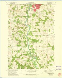
 1929 Durand1970 Print · USGSThe Chippewa River valley in the late 1920s reveals a landscape of river-bottom settlements and upland family farms. Genealogists can trace rural roots through numerous schoolhouses like Woods Corner Sch and landmarks like the Meridean Ferry.
 - 1932 Map of Durand
 1932 Durand1932 Print · USGSThe Chippewa River valley in the early 1930s is a landscape of complex waterways and bustling rural districts. Genealogists and historians can locate dozens of country schools like Luna Sch and trace the old rail lines serving Durand and Dunnville.2 unique versions available
 - 1940 Map of Menomonie, 1965 Print
 1940 Menomonie1965 Print · USGSDunn County in the early 1940s is a landscape of established river towns and a dense network of country schoolhouses. Genealogists can trace family roots through sites like Beyer Settlement Sch, Ideal Cem, and the County Asylum.2 unique versions available
 - 1942 Map of Menomonie
 1942 Menomonie1942 Print · USGSDunn County at the start of the 1940s reveals a region of thriving river towns and closely knit rural school districts. Genealogists can trace family roots through numerous country schools like Knapp Settlement School and local burial grounds such as Sherman Cem.
 - 1953 Map of Eau Claire, 1965 Print
 1953 Eau Claire1965 Print · USGSWest-central Wisconsin in the mid-fifties shows a landscape of river-valley industry and vast wildlife refuges during the transition from rails to modern highways. Genealogists and historians can trace the rail corridors of the Chicago and North Western or locate family-named landmarks like Decorah Mound and Chippewa Island.4 unique versions available
 - 1958 Map of Eau Claire
 1958 Eau Claire1958 Print · USGSWestern Wisconsin in the late fifties shows a landscape of growing regional hubs and massive wildlife refuges. Trace the rail lines of the Chicago and North Western between Eau Claire and Marshfield, or explore the terrain around Iron Mound and Lake Wissota.
 - 1964 Map of Eau Claire
 1964 Eau Claire1964 Print · USGSWest-central Wisconsin in the mid-1960s was a hub of river-driven industry and expanding rail networks. Researchers can trace historic homesteads near Menomonie, follow the Soo Line RR through Marshfield, or explore the grounds of the Camp McCoy Military Reservation.
 - 1972 Map of Meridean, 1975 Print
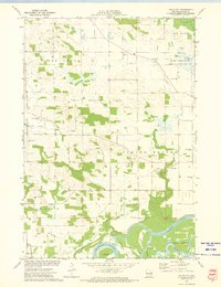
 1972 Meridean1975 Print · USGSThe Chippewa River valley in the early seventies shows a landscape of fertile bottoms and rural townships. Researchers can trace family roots at Fossum Cem and Peru Cem or locate old school sites like Grandview Sch.
 - 1972 Map of Durand North, 1975 Print
 1972 Durand North1975 Print · USGSThe Chippewa River valley in the early 1970s reveals a landscape of complex waterways and rail-side settlements. Researchers can trace the path of the Chicago Milwaukee St Paul and Pacific railroad past Dunnville or locate family sites like Evergreen Cem and Waubeek Mound.
 - 1972 Map of Menomonie South, 1975 Print
 1972 Menomonie South1975 Print · USGSDunn County at the start of the 1970s shows a landscape shaped by the Red Cedar River and the Milwaukee Road rail line. Genealogists and local historians can locate many rural cemeteries like Grandview Cem or explore the early campus of Stout State Univ.2 unique versions available
 - 1972 Map of Falls City, 1975 Print
 1972 Falls City1975 Print · USGSDunn County at the start of the 1970s reveals a landscape of active river bottoms and small-town landmarks. Genealogists and local historians can trace family ties at Falls City Cemetery, identify former school sites like Little Elk Creek School, and locate the C M St P & P rail line.
 - 1985 Map of Eau Claire
 1985 Eau Claire1985 Print · USGSWestern Wisconsin's river valleys and growing mid-century cities are captured here in the mid-eighties. Genealogists and historians can trace the paths of the Chicago and North Western railroad and locate rural landmarks like Dells Millpond and Nine Mile Island.2 unique versions available
 - 2022 Map of Menomonie South, 2022 Print
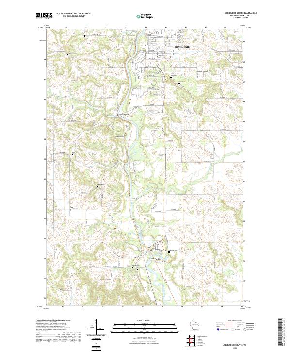 2022 Menomonie South2022 Print · USGSDunn County’s river valley south of Menomonie is shown here as it appears today, centered on the winding Red Cedar River. Researchers can locate several family and church burial sites like Grandview Cem and Saint Johns Cem, or trace the path of the Red Cedar State Trl.
 - 2022 Map of Meridean, 2022 Print
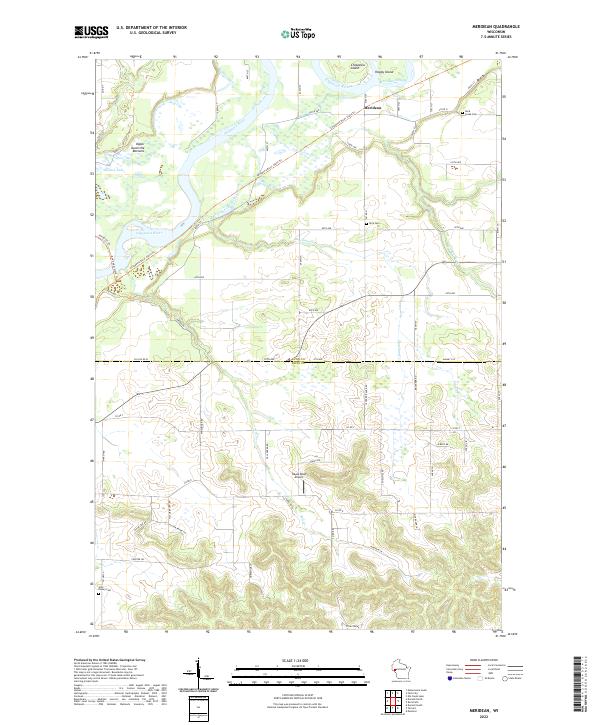 2022 Meridean2022 Print · USGSThe Chippewa River valley comes into focus in this recent survey of the Dunn and Pepin County line. Genealogists and local historians can trace legacy sites like Peru Cem, Rock Creek Cem, and the riverfront settlement of Meridean.
 - 2022 Map of Durand North, 2022 Print
 2022 Durand North2022 Print · USGSThe river confluence at the Dunn and Pepin county line shows a landscape shaped by water and former rail lines. Trace local history along the Red Cedar State Trl near Dunnville or locate family sites by Evergreen Cem and Waubeek Mound.
 - 2022 Map of Falls City, 2022 Print
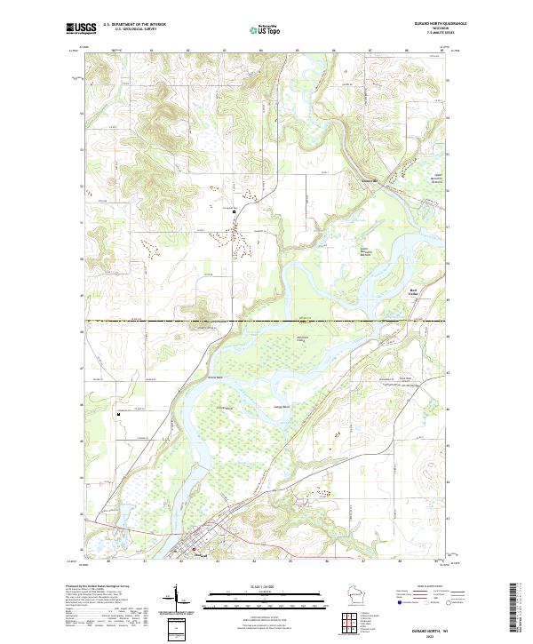
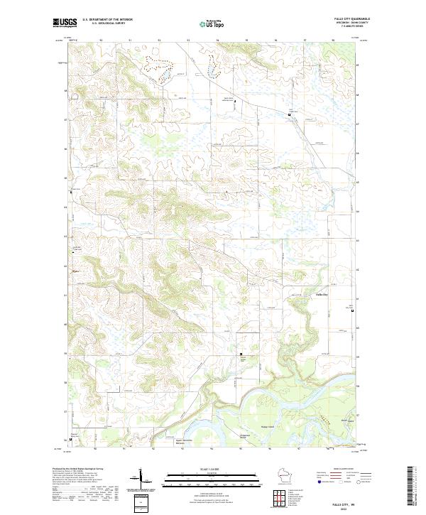 2022 Falls City2022 Print · USGSDunn County agricultural lands meet the winding waters of the Chippewa River in this modern survey of the Wisconsin countryside. Genealogists can locate several local burial sites like Falls City Cem and Forest Center Cem near the riverfront at Happy Island.
End of results
Showing maps 1-16 of 16
Top cities near Dunn
- Menomonie historical maps
- Mondovi historical maps
- Tainter historical maps
- Town of Tainter historical maps
- Red Cedar historical maps
- Durand historical maps
See more
Top neighborhoods of Dunn
Frequently asked questions
- What are the different types of historical maps available for Dunn?
- What is the oldest map of Dunn?
- Where can I purchase historical maps of Dunn for my home or office?
- Where can I download high-res historical maps of Dunn?
- Are there historical topographic maps available for Dunn?
- Is there historical aerial imagery available for Dunn?
- Where are historical maps of Dunn sourced from?