1970s Maps of Tainter, Wisconsin
Explore 4 historic maps of Tainter from the 1970s. These maps offer a rare glimpse into what life looked like during the 1970s — showing old roads, neighborhoods, homes, and landmarks that have changed or disappeared over time.
Whether you're researching your family's past, planning a metal detecting trip, or studying how Tainter's landscape evolved across the 1970s, these high-resolution maps are a powerful tool for exploring the history of this region.
- Focus on a specific era: All maps on this page are from the 1970s, giving you a focused view of this time period.
- See what’s changed: Compare century-old streets, trails, and buildings to today's modern landscape using overlays and satellite layers.
- Research with precision: Use these maps for genealogy, historical research, land use analysis, or educational projects.
- View, download, or print: Maps are fully viewable online in high resolution, and can be downloaded or printed for your own records.
Start exploring Tainter's history through authentic maps from the 1970s. This is your window into the past.
Tainter, WI maps
(4)- 1972 Map of Menomonie North, 1975 Print
 1972 Menomonie North1975 Print · USGSDunn County in the early seventies shows a landscape of expanding university life and river-based industry. Locate family roots at Sherman Cem, trace the railroad to Menomonie Junction, or study the grounds of Stout State Univ.
 - 1972 Map of Rusk, 1975 Print
 1972 Rusk1975 Print · USGSDunn County in the early seventies shows a landscape where the Chicago and North Western railroad still connects rural towns. Genealogists can trace local roots through several family and community sites, including Hill Grove Cem, Potters Field Cem, and the St Katherine Ch Cem near Rusk.
 - 1975 Map of Norton, 1978 Print
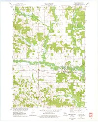
 1975 Norton1978 Print · USGSDunn County’s rural landscape is captured here in the mid-seventies, showing the agricultural heart of the region before modern expansion. Researchers can trace the Soo Line railroad and locate historical sites like Norton Ch and the Upper Popple Creek Cem.
 - 1975 Map of Wheeler, 1978 Print
 1975 Wheeler1978 Print · USGSDunn County life in the mid-seventies centers on the confluence of the Hay River and the Soo Line railroad. Researchers can trace rural landmarks like Hay River Cem, the Church of the Nazarene, and the small settlement of Dewey.
End of results
Showing maps 1-4 of 4
Top cities near Tainter
- Menomonie historical maps
- Union historical maps
- Town of Tainter historical maps
- Red Cedar historical maps
- Town of Red Cedar historical maps
- Colfax historical maps
See more
Top neighborhoods of Tainter
Frequently asked questions
- What are the different types of historical maps available for Tainter?
- What is the oldest map of Tainter?
- Where can I purchase historical maps of Tainter for my home or office?
- Where can I download high-res historical maps of Tainter?
- Are there historical topographic maps available for Tainter?
- Is there historical aerial imagery available for Tainter?
- Where are historical maps of Tainter sourced from?