1960s Maps of Florence County, Wisconsin
Explore 9 historic maps of Florence County from the 1960s. These maps offer a rare glimpse into what life looked like during the 1960s — showing old roads, neighborhoods, homes, and landmarks that have changed or disappeared over time.
Whether you're researching your family's past, planning a metal detecting trip, or studying how Florence County's landscape evolved across the 1960s, these high-resolution maps are a powerful tool for exploring the history of this region.
- Focus on a specific era: All maps on this page are from the 1960s, giving you a focused view of this time period.
- See what’s changed: Compare century-old streets, trails, and buildings to today's modern landscape using overlays and satellite layers.
- Research with precision: Use these maps for genealogy, historical research, land use analysis, or educational projects.
- View, download, or print: Maps are fully viewable online in high resolution, and can be downloaded or printed for your own records.
Start exploring Florence County's history through authentic maps from the 1960s. This is your window into the past.
Florence County, WI maps
(9)- 1960 Map of Iron River
 1960 Iron River1960 Print · USGSThe Upper Peninsula’s western reaches are shown in the late fifties, featuring the industrial infrastructure of the Copper Country and the vast Ottawa National Forest. Researchers can trace the rail lines of the Milwaukee Road through settlements like Bruce Crossing and the White Pine Mine.
 - 1961 Map of Iron River
 1961 Iron River1961 Print · USGSThe Upper Peninsula and northern Wisconsin are shown here in the early 1960s, a landscape defined by the iron range and vast timberlands. Researchers can trace the legacy of mining and rail transport through Caspian, the Lac Du Flambeau Indian Reservation, and the Milwaukee Road.
 - 1962 Map of Florence West, 1964 Print
 1962 Florence West1964 Print · USGSThe Wisconsin-Michigan borderlands come alive in this early 1960s survey of the iron-rich Northwoods. You can trace the Chicago and North Western rail line past old Mines and settlements like Tyran or Ridgetop.2 unique versions available
 - 1962 Map of Florence SW, 1964 Print
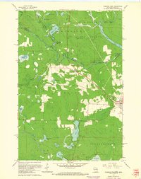
 1962 Florence SW1964 Print · USGSFlorence County in the early sixties is captured here as a landscape of protected timberlands and winding waterways. Genealogists and outdoor historians can locate the community of Fern or trace the Popple River past Patten Lake and Roadside Park.2 unique versions available
 - 1962 Map of Florence SE, 1964 Print
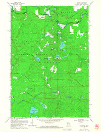
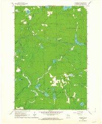 1962 Florence SE1964 Print · USGSFlorence County's river-cut timberlands are captured here in the early sixties, showing the landscape before modern development altered these remote woods. Researchers can trace the water levels of the Pine River Flowage and locate landmarks like the Lookout Tower and Homestead Park.2 unique versions available
 - 1962 Map of Florence East, 1964 Print
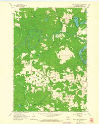
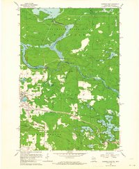 1962 Florence East1964 Print · USGSFlorence and the surrounding iron range townships appear at a peak of industrial activity in the early sixties. Trace the Chicago and North Western rail lines serving the Mines and the Hematite and Commonwealth settlements.
 - 1962 Map of Iron Mountain SW, 1964 Print
 1962 Iron Mountain SW1964 Print · USGSThe Wisconsin-Michigan border comes into focus in the early sixties, where the Pine River meets the Menominee River. Researchers can trace the rural layouts of Aurora and Kingsford, locating sites like the Power Plant and Aurora Free Ch.2 unique versions available
 - 1962 Map of Naults, 1964 Print
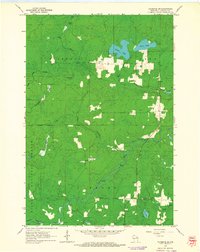
 1962 Naults1964 Print · USGSWisconsin's northern borderlands meet the Michigan state line in the early sixties, where the Brule River and Pine River wind through deep timber. Genealogists and historians can locate the Naults settlement along the Chicago and North Western tracks and identify the Florence Lookout Tower standing over a landscape of dozens of named glacial lakes.3 unique versions available
 - 1967 Map of Iron River, 1968 Print
 1967 Iron River1968 Print · USGSThe Upper Peninsula and northern Wisconsin borderlands are shown here in the late sixties, a landscape of deep woods and iron-country rail lines. Genealogists and historians can trace the lakeside settlements of L'Anse and Ontonagon or follow the Soo Line through towns like Michigamme and Nestoria.
End of results
Showing maps 1-9 of 9
Top cities of Florence County
- Aurora historical maps
- Florence historical maps
- Commonwealth historical maps
- Fence historical maps
- Tipler historical maps
- Fern historical maps
See more
Frequently asked questions
- What are the different types of historical maps available for Florence County?
- What is the oldest map of Florence County?
- Where can I purchase historical maps of Florence County for my home or office?
- Where can I download high-res historical maps of Florence County?
- Are there historical topographic maps available for Florence County?
- Is there historical aerial imagery available for Florence County?
- Where are historical maps of Florence County sourced from?