1940s Maps of Fern, Wisconsin
Explore 3 historic maps of Fern from the 1940s. These maps offer a rare glimpse into what life looked like during the 1940s — showing old roads, neighborhoods, homes, and landmarks that have changed or disappeared over time.
Whether you're researching your family's past, planning a metal detecting trip, or studying how Fern's landscape evolved across the 1940s, these high-resolution maps are a powerful tool for exploring the history of this region.
- Focus on a specific era: All maps on this page are from the 1940s, giving you a focused view of this time period.
- See what’s changed: Compare century-old streets, trails, and buildings to today's modern landscape using overlays and satellite layers.
- Research with precision: Use these maps for genealogy, historical research, land use analysis, or educational projects.
- View, download, or print: Maps are fully viewable online in high resolution, and can be downloaded or printed for your own records.
Start exploring Fern's history through authentic maps from the 1940s. This is your window into the past.
Fern, WI maps
(3)- 1941 Map of Florence
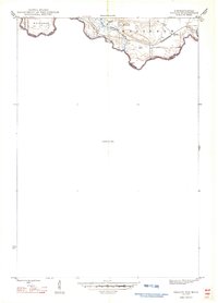
 1941 Florence1941 Print · USGSFlorence and the surrounding lake country appear in this early 1940s survey just as modern highways began to bypass the old rail corridors. Local researchers can trace rural schoolhouse locations like Fern Sch and landmarks like the Rainbow Firetower.
 - 1947 Map of Naults
 1947 Naults1947 Print · USGSThe Brule River borderland was a remote frontier of rail and timber in the late 1940s. Genealogists and historians can trace the settlement at Naults and the route of the Chicago and Northwestern railroad through the Mastodon area.
 - 1947 Map of Stager
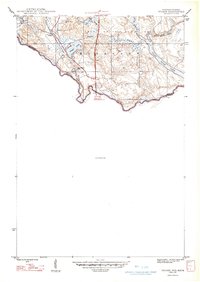 1947 Stager1947 Print · USGSThe Brule River forms the state boundary in the late 1940s, marking a landscape of wild waterways and essential rail lines. Trace the local rail history at Stager or explore the rugged river bends of the Brule River and the Horse Race Rapids.
End of results
Showing maps 1-3 of 3
Top cities near Fern
- Crystal Falls historical maps
- Laona historical maps
- Dunbar historical maps
- Aurora historical maps
- Goodman historical maps
- Mastodon historical maps
See more
Frequently asked questions
- What are the different types of historical maps available for Fern?
- What is the oldest map of Fern?
- Where can I purchase historical maps of Fern for my home or office?
- Where can I download high-res historical maps of Fern?
- Are there historical topographic maps available for Fern?
- Is there historical aerial imagery available for Fern?
- Where are historical maps of Fern sourced from?