1980s Maps of Alvin, Wisconsin
Explore 3 historic maps of Alvin from the 1980s. These maps offer a rare glimpse into what life looked like during the 1980s — showing old roads, neighborhoods, homes, and landmarks that have changed or disappeared over time.
Whether you're researching your family's past, planning a metal detecting trip, or studying how Alvin's landscape evolved across the 1980s, these high-resolution maps are a powerful tool for exploring the history of this region.
- Focus on a specific era: All maps on this page are from the 1980s, giving you a focused view of this time period.
- See what’s changed: Compare century-old streets, trails, and buildings to today's modern landscape using overlays and satellite layers.
- Research with precision: Use these maps for genealogy, historical research, land use analysis, or educational projects.
- View, download, or print: Maps are fully viewable online in high resolution, and can be downloaded or printed for your own records.
Start exploring Alvin's history through authentic maps from the 1980s. This is your window into the past.
Alvin, WI maps
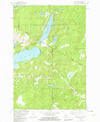
(3)- 1981 Map of Hagerman Lake
 1981 Hagerman Lake1981 Print · USGSThe Michigan-Wisconsin border comes alive in the early eighties as the Brule River winds through the twin national forests. Researchers can trace the Old Railroad Grade past Bass Lake or explore the settlement of Nelma along the riverbanks.
 - 1981 Map of Smoky Lake
 1981 Smoky Lake1981 Print · USGSThe Michigan-Wisconsin borderlands come into focus in the early 1980s, showcasing a landscape of timber and tourism. You can trace the remote shorelines of Smoky Lake and Big Sand Lake or locate the Phelps Municipal Landing Strip and Elvoy Springs.3 unique versions available
 - 1989 Map of Iron River, 1990 Print
 1989 Iron River1990 Print · USGSUpper Peninsula mining and timber lands are documented here in the late 1980s, showcasing the region's industrial and natural interface. Researchers can trace the iron heritage through the Monongahela Mine and local junctions like Kelso Junction and Amasa.
End of results
Showing maps 1-3 of 3
Top cities near Alvin
- Iron River historical maps
- Phelps historical maps
- Stambaugh historical maps
- Caspian historical maps
- Argonne historical maps
- Hiles historical maps
See more
Top neighborhoods of Alvin
Frequently asked questions
- What are the different types of historical maps available for Alvin?
- What is the oldest map of Alvin?
- Where can I purchase historical maps of Alvin for my home or office?
- Where can I download high-res historical maps of Alvin?
- Are there historical topographic maps available for Alvin?
- Is there historical aerial imagery available for Alvin?
- Where are historical maps of Alvin sourced from?