1980s Maps of Garden Valley, Wisconsin
Explore 7 historic maps of Garden Valley from the 1980s. These maps offer a rare glimpse into what life looked like during the 1980s — showing old roads, neighborhoods, homes, and landmarks that have changed or disappeared over time.
Whether you're researching your family's past, planning a metal detecting trip, or studying how Garden Valley's landscape evolved across the 1980s, these high-resolution maps are a powerful tool for exploring the history of this region.
- Focus on a specific era: All maps on this page are from the 1980s, giving you a focused view of this time period.
- See what’s changed: Compare century-old streets, trails, and buildings to today's modern landscape using overlays and satellite layers.
- Research with precision: Use these maps for genealogy, historical research, land use analysis, or educational projects.
- View, download, or print: Maps are fully viewable online in high resolution, and can be downloaded or printed for your own records.
Start exploring Garden Valley's history through authentic maps from the 1980s. This is your window into the past.
Garden Valley, WI maps
(7)- 1984 Map of Hixton
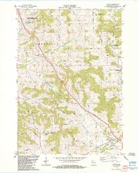 1984 Hixton1984 Print · USGSJackson County's agricultural valleys and coulees are documented here in the mid-1980s, showcasing the intersection of the Trempealeau River and the Green Bay and Western railroad. Researchers can locate unique local landmarks like Diphtheria Cem, Mound View Rock, and the historic settlement of Sechlerville.
 - 1984 Map of Price
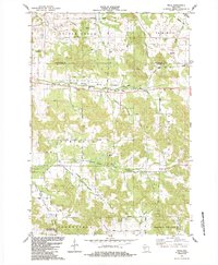 1984 Price1984 Print · USGSThe river valleys of Jackson County are shown in the mid-1980s, revealing a landscape shaped by rural conservation and timber-era transit. Researchers can find local landmarks like North Branch Cem, the Stephen Landing Strip, and the Old Railroad Grade.
 - 1984 Map of Alma Center
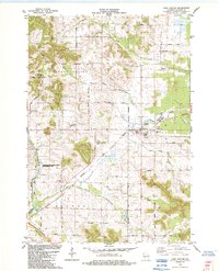 1984 Alma Center1984 Print · USGSAlma Center and its surrounding townships in the 1980s show a landscape defined by the intersection of rail history and the Trempealeau River. Researchers can trace the Chicago and North Western line, family burial grounds like Stanford Cem, and landmarks such as Silver Mound.
 - 1984 Map of Marshfield, 1985 Print
 1984 Marshfield1985 Print · USGSCentral Wisconsin's dairy heartland comes into focus during the mid-eighties as a busy network of rail and farm towns. Researchers can trace the path of the Soo Line, identify the grounds of McMillan State Wildlife Area, and locate smaller settlements like Spokeville and Tioga.2 unique versions available
 - 1985 Map of Eau Claire
 1985 Eau Claire1985 Print · USGSWestern Wisconsin's river valleys and growing mid-century cities are captured here in the mid-eighties. Genealogists and historians can trace the paths of the Chicago and North Western railroad and locate rural landmarks like Dells Millpond and Nine Mile Island.2 unique versions available
 - 1985 Map of Black River Falls
 1985 Black River Falls1985 Print · USGSCentral Wisconsin in the mid-1980s is defined by its sprawling wildlife refuges and the winding Black River corridor. Genealogists and researchers can trace rural settlements like Millston and Warrens or locate historical sites such as the Iron Mine and the grounds of Fort McCoy.2 unique versions available
 - 1985 Map of Winona
 1985 Winona1985 Print · USGSThe Mississippi River valley and the coulees of the Driftless Area are shown here in the mid-1980s as the river's lock-and-dam system was well-established. Researchers can trace the riverfront at Winona, explore the bluffs near Galesville, or locate landmarks like Sugarloaf and Merrick State Park.2 unique versions available
End of results
Showing maps 1-7 of 7
Top cities near Garden Valley
- Black River Falls historical maps
- Brockway historical maps
- Osseo historical maps
- Augusta historical maps
- Hale historical maps
- Irving historical maps
See more
Top neighborhoods of Garden Valley
Frequently asked questions
- What are the different types of historical maps available for Garden Valley?
- What is the oldest map of Garden Valley?
- Where can I purchase historical maps of Garden Valley for my home or office?
- Where can I download high-res historical maps of Garden Valley?
- Are there historical topographic maps available for Garden Valley?
- Is there historical aerial imagery available for Garden Valley?
- Where are historical maps of Garden Valley sourced from?