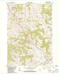
1984 Map of Hixton
USGS Topo · Published 1984About this map
Diphtheria Cem and Smallpox Cem stand as somber markers of the public health challenges faced by early residents in this section of Jackson County. The landscape is defined by the Driftless Area's characteristic coulees, such as Ellingson Coulee and May Coulee, which create a complex drainage pattern into Pigeon Creek and the Trempealeau River. The settlement at Hixton serves as a hub near the junction of the Green Bay and Western railroad and the river, while smaller hamlets like Sechlerville and Northfield anchor the surrounding agricultural valleys. Distinctive natural landmarks like Mound View Rock and Chimney Rock rise above Garden Valley, providing notable orientation points. Local history is deeply embedded in the distribution of community sites, from the Upper Pigeon Creek Ch to the scattered family and church burial grounds including Lutheran Cem and Curran Coulee Cem.
Find a feature on this map
48 named features on this map. Tap any name to fly to it.
Don’t see what you’re looking for? This feature index may not catch every label — zoom into the map to look around manually.
Map Details
Editions of this 1984 Hixton Map
This is the sole edition of this map. No revisions or reprints were ever made.
Other maps of this area

1924 · Black River Falls
USGS Topo · 1:62,500

1926 · Black River Falls
USGS Topo · 1:62,500

1927 · Blair
USGS Topo · 1:62,500

1935 · Osseo
USGS Topo · 1:48,000

1940 · Osseo
USGS Topo · 1:62,500

1948 · Fairchild
USGS Topo · 1:62,500

1949 · Fairchild
USGS Topo · 1:62,500

1953 · Eau Claire
USGS Topo · 1:250,000

1958 · Eau Claire
USGS Topo · 1:250,000

1964 · Eau Claire
USGS Topo · 1:250,000