1970s Maps of Ackley, Wisconsin
Explore 6 historic maps of Ackley from the 1970s. These maps offer a rare glimpse into what life looked like during the 1970s — showing old roads, neighborhoods, homes, and landmarks that have changed or disappeared over time.
Whether you're researching your family's past, planning a metal detecting trip, or studying how Ackley's landscape evolved across the 1970s, these high-resolution maps are a powerful tool for exploring the history of this region.
- Focus on a specific era: All maps on this page are from the 1970s, giving you a focused view of this time period.
- See what’s changed: Compare century-old streets, trails, and buildings to today's modern landscape using overlays and satellite layers.
- Research with precision: Use these maps for genealogy, historical research, land use analysis, or educational projects.
- View, download, or print: Maps are fully viewable online in high resolution, and can be downloaded or printed for your own records.
Start exploring Ackley's history through authentic maps from the 1970s. This is your window into the past.
Ackley, WI maps
(6)- 1973 Map of Antigo, 1976 Print
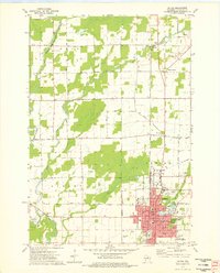 1973 Antigo1976 Print · USGSAntigo and the surrounding Langlade County countryside are captured in the early 1970s, as the city expanded around its river branches and rail corridors. Researchers can find numerous parochial schools and cemeteries, including St Hyacinths Sch and Bohemian Cem, alongside small rural hubs like Deerbrook.2 unique versions available
 - 1973 Map of Kalinke, 1976 Print
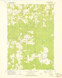
 1973 Kalinke1976 Print · USGSIn the early 1970s, the rural crossroads of Marathon County supported a quiet network of family farms and river-fed wetlands. Genealogists and local historians can locate early institutions like Zion Ch, Trinity Cem, and the Hewitt Texas Sch.
 - 1973 Map of Doering, 1976 Print
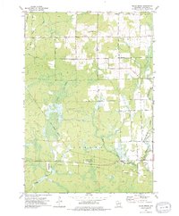
 1973 Doering1976 Print · USGSThe northern woods of Lincoln County come to life in this mid-seventies survey of the area around Doering. Genealogists and historians can trace the Old Railroad Grade past Wildwood Ch and find family names at Forest View Cem.
 - 1973 Map of Black Brook, 1976 Print
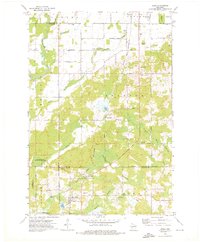
 1973 Black Brook1976 Print · USGSLanglade County's conservation lands and rural townships are captured here in the early seventies, as the modern wildlife areas were becoming established. Researchers can trace historic transportation routes along the Old RR Grade and locate local landmarks like Peck Cem and the Vilas Lookout Tower.
 - 1973 Map of Aniwa, 1976 Print
 1973 Aniwa1976 Print · USGSAniwa and the rural edges of Langlade, Shawano, and Marathon counties are captured here in the early seventies. You can trace the Chicago and North Western Railroad through Elmhurst or locate local landmarks like St Boniface Cem and Pleasant View Sch.
 - 1973 Map of Hogarty, 1976 Print
 1973 Hogarty1976 Print · USGSMarathon and Langlade counties come into focus in the early seventies, showing a landscape of timber, stone, and river water. Researchers can trace rural life through the Bethany Ch, an Old RR Grade, and the Aniwa Lookout Tower.
End of results
Showing maps 1-6 of 6
Top cities near Ackley
- Antigo historical maps
- Pine River historical maps
- Ringle historical maps
- Elcho historical maps
- Neva historical maps
- Norrie historical maps
See more
Frequently asked questions
- What are the different types of historical maps available for Ackley?
- What is the oldest map of Ackley?
- Where can I purchase historical maps of Ackley for my home or office?
- Where can I download high-res historical maps of Ackley?
- Are there historical topographic maps available for Ackley?
- Is there historical aerial imagery available for Ackley?
- Where are historical maps of Ackley sourced from?