1970s Maps of Ainsworth, Wisconsin
Explore 4 historic maps of Ainsworth from the 1970s. These maps offer a rare glimpse into what life looked like during the 1970s — showing old roads, neighborhoods, homes, and landmarks that have changed or disappeared over time.
Whether you're researching your family's past, planning a metal detecting trip, or studying how Ainsworth's landscape evolved across the 1970s, these high-resolution maps are a powerful tool for exploring the history of this region.
- Focus on a specific era: All maps on this page are from the 1970s, giving you a focused view of this time period.
- See what’s changed: Compare century-old streets, trails, and buildings to today's modern landscape using overlays and satellite layers.
- Research with precision: Use these maps for genealogy, historical research, land use analysis, or educational projects.
- View, download, or print: Maps are fully viewable online in high resolution, and can be downloaded or printed for your own records.
Start exploring Ainsworth's history through authentic maps from the 1970s. This is your window into the past.
Ainsworth, WI maps
(4)- 1973 Map of Mole Lake, 1976 Print
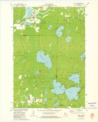 1973 Mole Lake1976 Print · USGSThe Mole Lake region of northern Wisconsin is shown in the 1970s as a landscape of glacial lakes and reservation lands. Researchers can trace the Soo Line rail corridor or locate landmarks like the Lookout Tower and Kingdom Hall.
 - 1973 Map of Pearson, 1977 Print
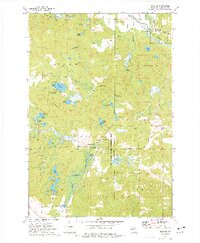 1973 Pearson1977 Print · USGSLanglade County in the early seventies shows a landscape defined by glacial lakes and the timber-era transition to conservation. Researchers can trace the Old Railroad Grade near Pearson or locate landmarks like the Pence Lake Lookout Tower and Crystal Spring Fish Hatchery.
 - 1973 Map of Pickerel, 1977 Print
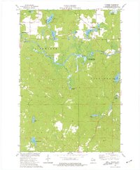 1973 Pickerel1977 Print · USGSLanglade County's water-rich landscape is captured here in the early seventies as the Wolf River winds through Ainsworth and Price. Researchers can trace the Old Railroad Grade, locate the Pearson Cem, or find local landmarks like New St Johns Ch.
 - 1973 Map of Post Lake, 1977 Print
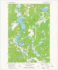 1973 Post Lake1977 Print · USGSThe Wolf River corridor in the early 1970s reveals a landscape of interconnected lakes and protected fishery lands. Researchers can trace lakeside developments near Post Lake and locate specific features like Knoke Spring, Spider Creek Flowage, and the Wolf River State Fishery Area.2 unique versions available
End of results
Showing maps 1-4 of 4
Top cities near Ainsworth
- Antigo historical maps
- Crandon historical maps
- Laona historical maps
- Elcho historical maps
- Nashville historical maps
- Polar historical maps
See more
Top neighborhoods of Ainsworth
Frequently asked questions
- What are the different types of historical maps available for Ainsworth?
- What is the oldest map of Ainsworth?
- Where can I purchase historical maps of Ainsworth for my home or office?
- Where can I download high-res historical maps of Ainsworth?
- Are there historical topographic maps available for Ainsworth?
- Is there historical aerial imagery available for Ainsworth?
- Where are historical maps of Ainsworth sourced from?