1980s Maps of Corning, Wisconsin
Explore 3 historic maps of Corning from the 1980s. These maps offer a rare glimpse into what life looked like during the 1980s — showing old roads, neighborhoods, homes, and landmarks that have changed or disappeared over time.
Whether you're researching your family's past, planning a metal detecting trip, or studying how Corning's landscape evolved across the 1980s, these high-resolution maps are a powerful tool for exploring the history of this region.
- Focus on a specific era: All maps on this page are from the 1980s, giving you a focused view of this time period.
- See what’s changed: Compare century-old streets, trails, and buildings to today's modern landscape using overlays and satellite layers.
- Research with precision: Use these maps for genealogy, historical research, land use analysis, or educational projects.
- View, download, or print: Maps are fully viewable online in high resolution, and can be downloaded or printed for your own records.
Start exploring Corning's history through authentic maps from the 1980s. This is your window into the past.
Corning, WI maps
(3)- 1980 Map of Goodrich
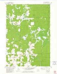 1980 Goodrich1980 Print · USGSTaylor County and Lincoln County meet in this northern Wisconsin landscape as it appeared in 1980. Local researchers can trace family landmarks like Goodrich Ch, explore the path of the Old Railroad Grade, and locate the small settlement of Interwald.2 unique versions available
 - 1980 Map of Athens
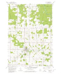 1980 Athens1980 Print · USGSMarathon County at the end of the 1970s shows a landscape of steady agricultural and timber-linked growth centered on the village of Athens. Genealogists and historians can trace the Old Railroad Grade and locate family markers at the local Cem or along Potato Creek.2 unique versions available
 - 1980 Map of Medford
 1980 Medford1980 Print · USGSNorth-central Wisconsin in the early eighties shows a landscape of dense timber and rail-linked settlements. Genealogists and historians can trace the Soo Line through towns like Medford and Westboro or locate family homesteads near Perkinstown and Athens.
End of results
Showing maps 1-3 of 3
Top cities near Corning
- Merrill historical maps
- Tomahawk historical maps
- Bradley historical maps
- Maine historical maps
- Athens historical maps
- Hamburg historical maps
See more
Frequently asked questions
- What are the different types of historical maps available for Corning?
- What is the oldest map of Corning?
- Where can I purchase historical maps of Corning for my home or office?
- Where can I download high-res historical maps of Corning?
- Are there historical topographic maps available for Corning?
- Is there historical aerial imagery available for Corning?
- Where are historical maps of Corning sourced from?