Old Maps of Plover, Wisconsin for Genealogy
Trace your family roots with 21 historic maps of Plover. These high-res maps reveal old neighborhoods, homesites, landmarks, and streets — helping you uncover where your ancestors lived and how the area evolved over time.
- Explore historic neighborhoods: Identify where your relatives may have lived in the 1800s or 1900s.
- Compare maps over time: Trace the changes in streets, buildings, and landmarks for multi-generational research.
- Perfect for genealogy & ancestry research: Used by family historians and researchers to map out lineage and migration.
These maps are an incredible resource for exploring your personal connection to Plover's past.
Plover, WI maps
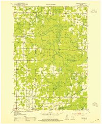
(21)- 1899 Map of Wausau, 1956 Print
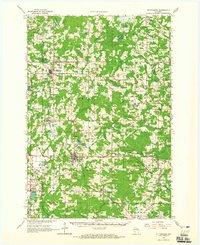
 1899 Wausau1956 Print · USGSMarathon County was a bustling timber and rail corridor at the turn of the century, anchored by the river power of Wausau and Merrill. Researchers can trace early logging lines like the Bull Dessert Logging R R and find vanished stops such as Dessert Junction and Nutterville.
 - 1902 Map of Wausau
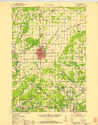
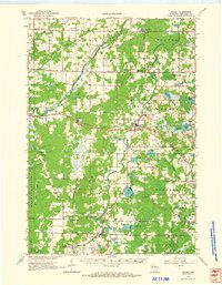
 1902 Wausau1902 Print · USGSWisconsin’s timber and rail heartland is meticulously documented at the turn of the century as Wausau and Merrill expand along the river. Genealogists can trace early homesteads and rail stops like Schofield, Granite Heights, and the grounds of the State Insane Asylum.2 unique versions available
 - 1951 Map of Doering, 1954 Print
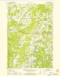
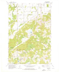
 1951 Doering1954 Print · USGSNorthwoods rural life is captured here in the early fifties across the intersection of Lincoln, Langlade, and Marathon counties. Genealogists can trace family footprints near Nutterville, Kalinke, and several country schools like Farrell Sch.2 unique versions available
 - 1952 Map of Antigo, 1954 Print
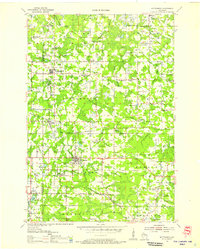
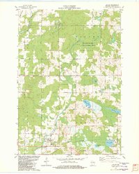
 1952 Antigo1954 Print · USGSAntigo and its surrounding townships are shown in detail during the early fifties, capturing a moment of transition for northern Wisconsin's rural school districts. Genealogists can locate family landmarks like the Bohemian Cem, St Johns Ch, and many local schools from Deerbrook to Mattoon.2 unique versions available
 - 1953 Map of Hatley, 1955 Print
 1953 Hatley1955 Print · USGSMarathon County's eastern farming and timber lands are captured here in the early fifties as the rural school system began to consolidate. Genealogists can trace family footprints at St Francis Cem or follow the old Chicago and North Western rail line through Hatley.
 - 1954 Map of Wittenberg, 1956 Print
 1954 Wittenberg1956 Print · USGSWisconsin’s timber and rail country is captured here during the mid-fifties as many small rural schoolhouses were being phased out. Genealogists and local historians can trace family locations near Forest Home Cem, the settlement of Regina, or the St Johannes Ch.
 - 1954 Map of Iron Mountain, 1964 Print
 1954 Iron Mountain1964 Print · USGSUpper Michigan and Northeastern Wisconsin are shown in detail during the mid-fifties, when the logging and mining economies still moved by rail. Trace the rail lines of the Soo Line to remote stops like Koepenick Station or explore the Iron Range near Iron Mountain.2 unique versions available
 - 1955 Map of Green Bay, 1968 Print
 1955 Green Bay1968 Print · USGSCentral and Eastern Wisconsin are captured here in the mid-fifties, showing the industrial growth of the Fox Valley and Wisconsin River corridors. Genealogists and historians can trace rail lines like the Green Bay and Western through settlements like Weyauwega, Clintonville, and Pulaski.2 unique versions available
 - 1959 Map of Iron Mountain
 1959 Iron Mountain1959 Print · USGSThe northwoods of Wisconsin and the Michigan border are captured here in the mid-fifties, showing a landscape defined by timber, water, and rail. Researchers can trace historic junctions like Hiles Junction, the expansive Nicolet National Forest, and lakefront settlements from Rhinelander to Tomahawk.2 unique versions available
 - 1964 Map of Wittenberg, 1965 Print
 1964 Wittenberg1965 Print · USGSSettled along the border of Marathon and Shawano counties in the 1960s, this area shows a landscape shaped by timber and rail. Researchers can trace local lineage through several sites like Homme Home for Boys, St Philomena Ch, and Holy Family Cem.2 unique versions available
 - 1964 Map of Hatley, 1966 Print
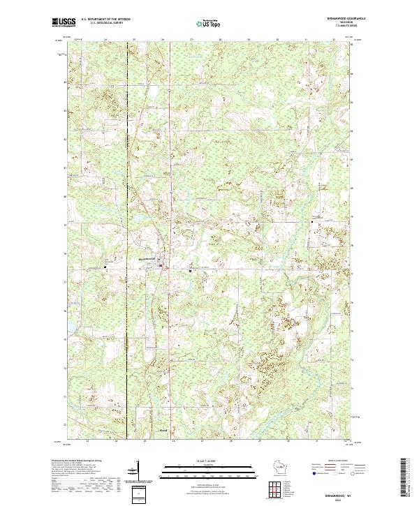
 1964 Hatley1966 Print · USGSMarathon County in the mid-1960s reveals a rural landscape defined by the Chicago and North Western Railroad and glacial lake clusters. Researchers can locate family landmarks like Forestville Cem, Easton Sch, and the Elderon Lookout Tower.
 - 1973 Map of Aniwa, 1976 Print
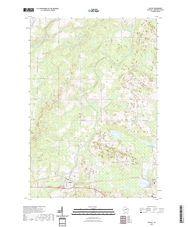
 1973 Aniwa1976 Print · USGSAniwa and the rural edges of Langlade, Shawano, and Marathon counties are captured here in the early seventies. You can trace the Chicago and North Western Railroad through Elmhurst or locate local landmarks like St Boniface Cem and Pleasant View Sch.
 - 1973 Map of Hogarty, 1976 Print
 1973 Hogarty1976 Print · USGSMarathon and Langlade counties come into focus in the early seventies, showing a landscape of timber, stone, and river water. Researchers can trace rural life through the Bethany Ch, an Old RR Grade, and the Aniwa Lookout Tower.
 - 1982 Map of Hatley
 1982 Hatley1982 Print · USGSThe village of Hatley and the community of Norrie are shown here in the early eighties as the railroad still influenced the local layout. Researchers can trace family history at St Florian Sch Cem or explore the shores of Go-To-It Lake and the Plover River.
 - 1982 Map of Birnamwood
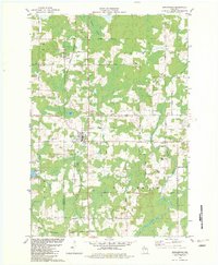 1982 Birnamwood1982 Print · USGSThe village of Birnamwood and its railroad connections are documented here in the early eighties. Genealogists can locate family sites at St Philomena Cem, Forest Cem, and St Johns Ch Cem along the Embarrass River valley.
 - 1984 Map of Wausau, 1990 Print
 1984 Wausau1990 Print · USGSMarathon and Portage counties come into focus during the mid-eighties as industrial river towns and sprawling conservation areas define the Central Wisconsin landscape. Researchers can trace the rail corridors of the Soo Line or locate rural landmarks like Rib Mountain State Park and St Marys Cem.
 - 1990 Map of Merrill, 1991 Print
 1990 Merrill1991 Print · USGSWisconsin's Northwoods transition from timber industry to recreation in the 1990s, centered on the river corridors of Lincoln and Langlade counties. Genealogists and historians can trace rail history along the Soo Line and Old RR Grade between Merrill and Antigo.
 - 2022 Map of Birnamwood, 2022 Print
 2022 Birnamwood2022 Print · USGSThe borderlands of Marathon and Shawano counties are revealed here in the twenty-first century, centered on the village of Birnamwood. Trace the convergence of the Wiouwash State Trl and Mountain-Bay State Trl near Eland or locate family plots at Forest Cem.
 - 2022 Map of Hatley, 2022 Print
 2022 Hatley2022 Print · USGSEastern Marathon County remains a landscape of glacial lakes and river valleys in this modern survey. Researchers can trace historic church sites like Saint Florian Parish Cem and the routes of the Ice Age National Scenic Trl and Mountain-Bay State Trl.
 - 2022 Map of Aniwa, 2022 Print
 2022 Aniwa2022 Print · USGSThe borderlands of Marathon, Langlade, and Shawano counties are captured here in the early 2020s, showing a landscape of dense wetlands and rural settlements. Researchers can locate family heritage sites like Saint Boniface Cem and Hall Pioneer Cem, or trace the path of the Ice Age National Scenic Trl past Bear Lake.
 - 2022 Map of Hogarty, 2022 Print
 2022 Hogarty2022 Print · USGSMarathon County's river valleys and timberlands are mapped here in the early twenty-first century, showing the rural character of the Northwoods. Genealogists and hikers can trace the Ice Age National Scenic Trl or locate the Bethany Cem near Hogarty.
End of results
Showing maps 1-21 of 21
Top cities near Plover
- Weston historical maps
- Antigo historical maps
- Kronenwetter historical maps
- Pine River historical maps
- Ringle historical maps
- Wittenberg historical maps
See more
Top neighborhoods of Plover
Frequently asked questions
- What are the different types of historical maps available for Plover?
- What is the oldest map of Plover?
- Where can I purchase historical maps of Plover for my home or office?
- Where can I download high-res historical maps of Plover?
- Are there historical topographic maps available for Plover?
- Is there historical aerial imagery available for Plover?
- Where are historical maps of Plover sourced from?