1970s Maps of Wausaukee, Wisconsin
Explore 2 historic maps of Wausaukee from the 1970s. These maps offer a rare glimpse into what life looked like during the 1970s — showing old roads, neighborhoods, homes, and landmarks that have changed or disappeared over time.
Whether you're researching your family's past, planning a metal detecting trip, or studying how Wausaukee's landscape evolved across the 1970s, these high-resolution maps are a powerful tool for exploring the history of this region.
- Focus on a specific era: All maps on this page are from the 1970s, giving you a focused view of this time period.
- See what’s changed: Compare century-old streets, trails, and buildings to today's modern landscape using overlays and satellite layers.
- Research with precision: Use these maps for genealogy, historical research, land use analysis, or educational projects.
- View, download, or print: Maps are fully viewable online in high resolution, and can be downloaded or printed for your own records.
Start exploring Wausaukee's history through authentic maps from the 1970s. This is your window into the past.
Wausaukee, WI maps
(2)- 1972 Map of Mount Tom, 1975 Print
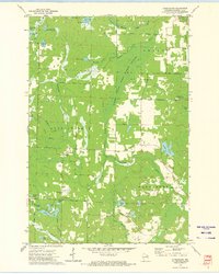
 1972 Mount Tom1975 Print · USGSMarinette County’s lake-dotted landscape is captured here in the early 1970s, showing the rural intersections of the Northwoods. Genealogists and hikers can trace old routes like Moonshine Hill Road or locate landmarks like the Lookout Tower and Retcof Lake.
 - 1972 Map of Athelstane, 1975 Print
 1972 Athelstane1975 Print · USGSMarinette County's lake-filled woodlands are documented here in the early 1970s, as a rural economy transitioned away from its rail-dependent roots. Genealogists can trace family landmarks like the Athelstane Cem, Assembly of God Ch, and the Old Railroad Grade north of town.
End of results
Showing maps 1-2 of 2
Top cities near Wausaukee
- Porterfield historical maps
- Dunbar historical maps
- Beaver historical maps
- Pembine historical maps
- Crivitz historical maps
- Amberg historical maps
See more
Top neighborhoods of Wausaukee
Frequently asked questions
- What are the different types of historical maps available for Wausaukee?
- What is the oldest map of Wausaukee?
- Where can I purchase historical maps of Wausaukee for my home or office?
- Where can I download high-res historical maps of Wausaukee?
- Are there historical topographic maps available for Wausaukee?
- Is there historical aerial imagery available for Wausaukee?
- Where are historical maps of Wausaukee sourced from?