1900s (20th Century) Maps of Bay View, Milwaukee
Explore 14 historic maps of Bay View from the 1900s (20th Century). These maps offer a rare glimpse into what life looked like during the 1900s — showing old roads, neighborhoods, homes, and landmarks that have changed or disappeared over time.
Whether you're researching your family's past, planning a metal detecting trip, or studying how Bay View's landscape evolved across the 1900s, these high-resolution maps are a powerful tool for exploring the history of this region.
- Focus on a specific era: All maps on this page are from the 1900s, giving you a focused view of this time period.
- See what’s changed: Compare century-old streets, trails, and buildings to today's modern landscape using overlays and satellite layers.
- Research with precision: Use these maps for genealogy, historical research, land use analysis, or educational projects.
- View, download, or print: Maps are fully viewable online in high resolution, and can be downloaded or printed for your own records.
Start exploring Bay View's history through authentic maps from the 1900s. This is your window into the past.
Bay View, Milwaukee maps
(14)- 1901 Map of Milwaukee
 1901 Milwaukee1901 Print · USGSThe Milwaukee lakefront and surrounding townships are shown here as a burgeoning industrial and rail corridor at the start of the 1900s. Trace early property and rail development at Whitefish Bay, Wauwatosa, and the defunct Dillman Sta. depot.
 - 1901 Map of Bayview
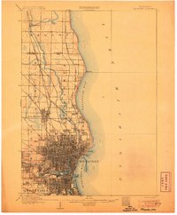
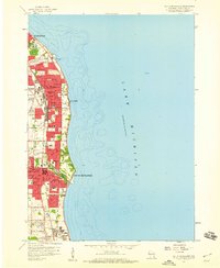
 1901 Bayview1901 Print · USGSThe Lake Michigan shoreline south of Milwaukee comes alive in the late Victorian era as industry and rail lines expand. Trace early coastal growth in Cudahy and South Milwaukee, or locate old interior settlements like New Coeln, Kilbournville, and Lamberton P.O..4 unique versions available
 - 1906 Map of Milwaukee
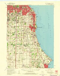
 1906 Milwaukee1906 Print · USGSThe Milwaukee lakefront and its surrounding townships show the height of early twentieth-century rail and river development. Researchers can trace ancestral property near National Home or locate vanished stops along the Lake Shore Line and Chicago Milwaukee and St Paul RR.4 unique versions available
 - 1954 Map of Milwaukee, 1967 Print
 1954 Milwaukee1967 Print · USGSCoastal life and maritime commerce across Lake Michigan are seen here during the mid-fifties, bridging Wisconsin's industrial hubs and Michigan's timberlands. Genealogists and historians can trace the rail lines of the Grand Trunk Western and find long-established ports like Ludington, Port Washington, and Muskegon.3 unique versions available
 - 1958 Map of Milwaukee
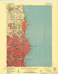
 1958 Milwaukee1958 Print · USGSThe shorelines of Lake Michigan in the late fifties reveal a landscape of bustling ferry ports and growing industrial suburbs. Genealogists and historians can trace rail networks like the Chesapeake & Ohio and locate landmarks such as Little Sable Point and Holy Cross Church.
 - 1958 Map of Milwaukee, 1960 Print
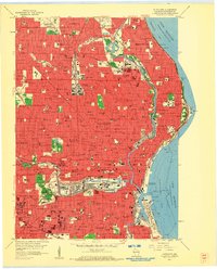 1958 Milwaukee1960 Print · USGSMid-century Milwaukee is a landscape of dense neighborhoods, massive rail yards, and industrial lakefronts during its peak urban era. Genealogists and historians can trace the city's growth through dozens of parochial schools like St Marys Sch and large burial grounds including Wanderers Rest Cemetery and Forest Home Cemetery.3 unique versions available
 - 1958 Map of Milwaukee, 1960 Print
 1958 Milwaukee1960 Print · USGSGreater Milwaukee and the Ozaukee County border appear here at the end of the fifties, when the city’s residential and academic core was firmly established. Genealogists can locate family-named institutions like St Rose Sch & Ch, trace the lakefront in Whitefish Bay, and find old rail lines such as the Chicago and North Western.3 unique versions available
 - 1958 Map of Greendale, 1960 Print
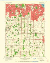 1958 Greendale1960 Print · USGSSouthern Milwaukee and its neighbors are seen here in the late fifties, as suburban expansion begins to surround major hubs. Genealogists can trace family plots across Forest Home Cemetery and St Adalberts Cemetery, or locate vanished landmarks like the County House of Correction.3 unique versions available
 - 1958 Map of South Milwaukee, 1960 Print
 1958 South Milwaukee1960 Print · USGSThe Milwaukee lakefront in the late fifties shows a dense corridor of industry and education stretching from St Francis down to Carrollville. Researchers can trace the development of numerous schools and churches, including St Pauls Sch, Holy Sepulchre Cemetery, and the lakefront Powerplant.4 unique versions available
 - 1958 Map of South Milwaukee, 1960 Print
 1958 South Milwaukee1960 Print · USGSCoastal Milwaukee County and northern Racine County show a landscape of rapid mid-century development and heavy industry along Lake Michigan. Researchers can trace the layout of family-named roads and rural schools like Caddy Vista Sch, alongside major landmarks like General Mitchell Field and Paynesville Chapel.2 unique versions available
 - 1958 Map of Racine, 1971 Print
 1958 Racine1971 Print · USGSThe Lake Michigan shoreline in the late fifties was a study in contrasts between the industrial bustle of Kenosha and the quiet woods of the Allegan State Forest. Genealogists and historians can trace the urban footprint of Evanston or locate strategic sites like Fort Sheridan and the Wind Point Light.3 unique versions available
 - 1962 Map of Racine
 1962 Racine1962 Print · USGSThe Lake Michigan shoreline in the early sixties reveals a fascinating contrast between the dense industrial rail hubs of RACINE and CHICAGO and the forested dunes of Michigan. Local historians can trace military installations like Fort Sheridan or explore the numerous inland retreats around Paw Paw Lake and Sister Lakes.
 - 1980 Map of Milwaukee, 1981 Print
 1980 Milwaukee1981 Print · USGSThe Lake Michigan shoreline and Milwaukee's urban sprawl are captured here at the start of the 1980s. Local researchers can trace family landmarks like Graceland Cemetery, educational sites like Milwaukee-Downer College, and the northern rail lines of the Chicago and North Western.
 - 1980 Map of Racine, 1981 Print
 1980 Racine1981 Print · USGSThe Lake Michigan shoreline at the start of the 1980s reveals a bustling industrial corridor from Milwaukee to Kenosha. Genealogists and local historians can trace family roots through numerous sites like Forest Home Cem or locate former rail stops along the C & N W and C M St P & P lines.
End of results
Showing maps 1-14 of 14
Frequently asked questions
- What are the different types of historical maps available for Bay View?
- What is the oldest map of Bay View?
- Where can I purchase historical maps of Bay View for my home or office?
- Where can I download high-res historical maps of Bay View?
- Are there historical topographic maps available for Bay View?
- Is there historical aerial imagery available for Bay View?
- Where are historical maps of Bay View sourced from?