1950s Maps of South Milwaukee, Wisconsin
Explore 4 historic maps of South Milwaukee from the 1950s. These maps offer a rare glimpse into what life looked like during the 1950s — showing old roads, neighborhoods, homes, and landmarks that have changed or disappeared over time.
Whether you're researching your family's past, planning a metal detecting trip, or studying how South Milwaukee's landscape evolved across the 1950s, these high-resolution maps are a powerful tool for exploring the history of this region.
- Focus on a specific era: All maps on this page are from the 1950s, giving you a focused view of this time period.
- See what’s changed: Compare century-old streets, trails, and buildings to today's modern landscape using overlays and satellite layers.
- Research with precision: Use these maps for genealogy, historical research, land use analysis, or educational projects.
- View, download, or print: Maps are fully viewable online in high resolution, and can be downloaded or printed for your own records.
Start exploring South Milwaukee's history through authentic maps from the 1950s. This is your window into the past.
South Milwaukee, WI maps
(4)- 1958 Map of Greendale, 1960 Print
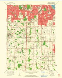 1958 Greendale1960 Print · USGSSouthern Milwaukee and its neighbors are seen here in the late fifties, as suburban expansion begins to surround major hubs. Genealogists can trace family plots across Forest Home Cemetery and St Adalberts Cemetery, or locate vanished landmarks like the County House of Correction.3 unique versions available
 - 1958 Map of South Milwaukee, 1960 Print
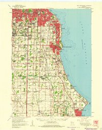
 1958 South Milwaukee1960 Print · USGSThe Milwaukee lakefront in the late fifties shows a dense corridor of industry and education stretching from St Francis down to Carrollville. Researchers can trace the development of numerous schools and churches, including St Pauls Sch, Holy Sepulchre Cemetery, and the lakefront Powerplant.4 unique versions available
 - 1958 Map of South Milwaukee, 1960 Print
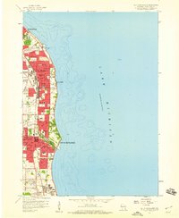
 1958 South Milwaukee1960 Print · USGSCoastal Milwaukee County and northern Racine County show a landscape of rapid mid-century development and heavy industry along Lake Michigan. Researchers can trace the layout of family-named roads and rural schools like Caddy Vista Sch, alongside major landmarks like General Mitchell Field and Paynesville Chapel.2 unique versions available
 - 1958 Map of Racine, 1971 Print
 1958 Racine1971 Print · USGSThe Lake Michigan shoreline in the late fifties was a study in contrasts between the industrial bustle of Kenosha and the quiet woods of the Allegan State Forest. Genealogists and historians can trace the urban footprint of Evanston or locate strategic sites like Fort Sheridan and the Wind Point Light.3 unique versions available
End of results
Showing maps 1-4 of 4
Top cities near South Milwaukee
- Milwaukee historical maps
- Racine historical maps
- West Allis historical maps
- Wauwatosa historical maps
- Brookfield historical maps
- New Berlin historical maps
See more
Top neighborhoods of South Milwaukee
- Lakeview historical maps
- Blakewood historical maps
- Historic Grant Park historical maps
- South Chicago Avenue historical maps
- Historic Lakeview historical maps
- Parkway Heights historical maps
See more
Frequently asked questions
- What are the different types of historical maps available for South Milwaukee?
- What is the oldest map of South Milwaukee?
- Where can I purchase historical maps of South Milwaukee for my home or office?
- Where can I download high-res historical maps of South Milwaukee?
- Are there historical topographic maps available for South Milwaukee?
- Is there historical aerial imagery available for South Milwaukee?
- Where are historical maps of South Milwaukee sourced from?