1970s Maps of Little Suamico, Wisconsin
Explore 5 historic maps of Little Suamico from the 1970s. These maps offer a rare glimpse into what life looked like during the 1970s — showing old roads, neighborhoods, homes, and landmarks that have changed or disappeared over time.
Whether you're researching your family's past, planning a metal detecting trip, or studying how Little Suamico's landscape evolved across the 1970s, these high-resolution maps are a powerful tool for exploring the history of this region.
- Focus on a specific era: All maps on this page are from the 1970s, giving you a focused view of this time period.
- See what’s changed: Compare century-old streets, trails, and buildings to today's modern landscape using overlays and satellite layers.
- Research with precision: Use these maps for genealogy, historical research, land use analysis, or educational projects.
- View, download, or print: Maps are fully viewable online in high resolution, and can be downloaded or printed for your own records.
Start exploring Little Suamico's history through authentic maps from the 1970s. This is your window into the past.
Little Suamico, WI maps
(5)- 1974 Map of Abrams, 1977 Print
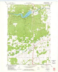 1974 Abrams1977 Print · USGSOconto County in the mid-seventies shows a landscape defined by the Oconto and Pensaukee rivers. Local historians can trace the rail junction at Abrams or find family-named landmarks like Heider Road and the Stiles Lookout Tower.
 - 1974 Map of Pensaukee, 1977 Print
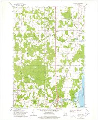
 1974 Pensaukee1977 Print · USGSCoastal Oconto County comes into focus in the 1970s as the river mouths at Pensaukee and the rural reaches of Brookside are mapped in detail. Genealogists and researchers can trace family-named routes like Thome Road and locate the Brookside Cemetery near the river banks.
 - 1974 Map of Little Tail Point, 1978 Print
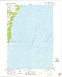 1974 Little Tail Point1978 Print · USGSThe Oconto County shoreline in the mid-seventies is defined by the narrow spit of Little Tail Point and the adjacent wetlands. Genealogists and historians can trace the Chicago and North Western rail corridor and early access roads at Lade Beach.
 - 1974 Map of Suamico, 1978 Print
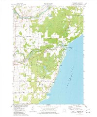
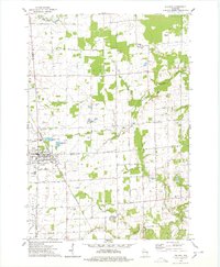
 1974 Suamico1978 Print · USGSCoastal Wisconsin settlements like Little Suamico and Sobieski are shown here as they appeared in the mid-seventies before significant modern expansion. Genealogists can trace family landmarks such as St Benedict Cem, Riverside Cem, and the old rail lines of the Chicago and North Western.
 - 1974 Map of Pulaski, 1978 Print
 1974 Pulaski1978 Print · USGSNear the intersection of three counties in the mid-1970s, the village of Pulaski is shown alongside its rail and religious roots. Genealogists can locate family sites at the Franciscan Monastery, St Joseph Cem, and Polish National Cem.
End of results
Showing maps 1-5 of 5
Top cities near Little Suamico
- Green Bay historical maps
- Howard historical maps
- Allouez historical maps
- Bellevue historical maps
- Suamico historical maps
- Oconto historical maps
See more
Top neighborhoods of Little Suamico
Frequently asked questions
- What are the different types of historical maps available for Little Suamico?
- What is the oldest map of Little Suamico?
- Where can I purchase historical maps of Little Suamico for my home or office?
- Where can I download high-res historical maps of Little Suamico?
- Are there historical topographic maps available for Little Suamico?
- Is there historical aerial imagery available for Little Suamico?
- Where are historical maps of Little Suamico sourced from?