1970s Maps of Minocqua, Wisconsin
Explore 8 historic maps of Minocqua from the 1970s. These maps offer a rare glimpse into what life looked like during the 1970s — showing old roads, neighborhoods, homes, and landmarks that have changed or disappeared over time.
Whether you're researching your family's past, planning a metal detecting trip, or studying how Minocqua's landscape evolved across the 1970s, these high-resolution maps are a powerful tool for exploring the history of this region.
- Focus on a specific era: All maps on this page are from the 1970s, giving you a focused view of this time period.
- See what’s changed: Compare century-old streets, trails, and buildings to today's modern landscape using overlays and satellite layers.
- Research with precision: Use these maps for genealogy, historical research, land use analysis, or educational projects.
- View, download, or print: Maps are fully viewable online in high resolution, and can be downloaded or printed for your own records.
Start exploring Minocqua's history through authentic maps from the 1970s. This is your window into the past.
Minocqua, WI maps
(8)- 1971 Map of Pier Lake, 1973 Print
 1971 Pier Lake1973 Print · USGSOneida County's western lakes and timberlands are captured here in the early seventies, showing a landscape shaped by the Willow Reservoir. Genealogists and local historians can trace the remote St Francis of Assisi Ch and old forest routes like Thunder Creek Road and Pier Lake Road.2 unique versions available
 - 1971 Map of Pike Lake SE, 1973 Print
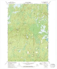 1971 Pike Lake SE1973 Print · USGSThe northern Wisconsin wilderness of Price and Oneida Counties is captured here in the early 1970s. Outdoor researchers and local historians can trace the headwaters of Foulds Creek and locate landmarks like the Lookout Tower and Steverson Spring.2 unique versions available
 - 1971 Map of Pike Lake, 1973 Print
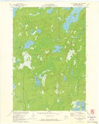
 1971 Pike Lake1973 Print · USGSIn the early 1970s, the lake country at the junction of Price, Iron, and Vilas counties was a landscape of deep forests and interconnected waterways. Researchers can trace the Chippewa Trail, locate the Lookout Tower on Sentinel Point, and explore the shorelines of Round Lake and Pike Lake.
 - 1971 Map of Lac Du Flambeau, 1973 Print
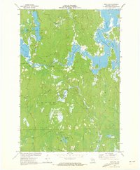
 1971 Lac Du Flambeau1973 Print · USGSLac du Flambeau and its surrounding lakes are captured here in the early seventies, showing a landscape defined by water and forest. Researchers can trace the Reservation Boundary and find local landmarks like the Indian Agency and Strawberry Island.3 unique versions available
 - 1971 Map of Burrows Lake, 1973 Print
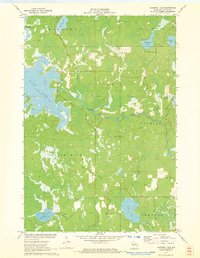 1971 Burrows Lake1973 Print · USGSOneida County's northwoods are captured in the early seventies, showing a landscape defined by the Willow Reservoir and the Tomahawk River. Researchers can trace old woods routes and locate landmarks like the Jack Pine Lookout Tower and the Cranberry Bog.2 unique versions available
 - 1971 Map of Lac Du Flambeau SW, 1973 Print
 1971 Lac Du Flambeau SW1973 Print · USGSOneida County's dense lake country is captured here in the early 1970s, showcasing a landscape of timber and wetlands before significant modern development. Researchers can trace historic access routes like Camp Nine Road and locate distinctive landmarks including the Squirrel Hill Lookout Tower and the sprawling Cranberry Bog.2 unique versions available
 - 1971 Map of Mercer Lake, 1973 Print
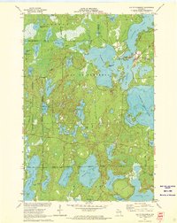
 1971 Mercer Lake1973 Print · USGSOneida County's lake-strewn wilderness is captured here in the early seventies, spanning the townships of Minocqua and Hazelhurst. Genealogists and historians can trace the course of the Tomahawk River and locate landmarks like Kitty Springs, Blue Lake, and the winding Manhardt Road.
 - 1971 Map of Fence Lake, 1973 Print
 1971 Fence Lake1973 Print · USGSThe Vilas County lake country is captured here in the early 1970s, during a time of significant recreational growth within the Lac du Flambeau Indian Reservation. Researchers can trace the Chicago and North Western rail line past Marlands or locate landmarks like the Flambeau Lookout Tower.
End of results
Showing maps 1-8 of 8
Top cities near Minocqua
- Lac du Flambeau historical maps
- Hazelhurst historical maps
- Lake Tomahawk historical maps
- Boulder Junction historical maps
- Fifield historical maps
- Woodruff historical maps
See more
Top neighborhoods of Minocqua
Frequently asked questions
- What are the different types of historical maps available for Minocqua?
- What is the oldest map of Minocqua?
- Where can I purchase historical maps of Minocqua for my home or office?
- Where can I download high-res historical maps of Minocqua?
- Are there historical topographic maps available for Minocqua?
- Is there historical aerial imagery available for Minocqua?
- Where are historical maps of Minocqua sourced from?