2020s Maps of Minocqua, Wisconsin
Explore 11 historic maps of Minocqua from the 2020s. These maps offer a rare glimpse into what life looked like during the 2020s — showing old roads, neighborhoods, homes, and landmarks that have changed or disappeared over time.
Whether you're researching your family's past, planning a metal detecting trip, or studying how Minocqua's landscape evolved across the 2020s, these high-resolution maps are a powerful tool for exploring the history of this region.
- Focus on a specific era: All maps on this page are from the 2020s, giving you a focused view of this time period.
- See what’s changed: Compare century-old streets, trails, and buildings to today's modern landscape using overlays and satellite layers.
- Research with precision: Use these maps for genealogy, historical research, land use analysis, or educational projects.
- View, download, or print: Maps are fully viewable online in high resolution, and can be downloaded or printed for your own records.
Start exploring Minocqua's history through authentic maps from the 2020s. This is your window into the past.
Minocqua, WI maps
(11)- 2022 Map of Mercer Lake, 2022 Print
 2022 Mercer Lake2022 Print · USGSOneida County's lake country is seen here in the early twenty-first century, showing the dense network of water bodies and local roads. Genealogists and historians can trace shoreline developments like Woodland Hts and locate specific features like Kitty Springs, Bear Lake, and Silver Lake.
 - 2022 Map of Thunder Creek, 2022 Print
 2022 Thunder Creek2022 Print · USGSNorthwoods wilderness on the border of Price and Oneida counties is documented here in the early 2020s. Trace recreational trails and remote forest routes like the Price Co Snowmobile-120a Trl, Thunder Cr, and the shoreline of Willow Lake.
 - 2022 Map of Burrows Lake, 2022 Print
 2022 Burrows Lake2022 Print · USGSOneida County's lake country is captured here in the early 2020s, showing the intricate waterways around the Tomahawk River. Researchers can trace the shoreline of Willow Reservoir or locate the Halfbreed Rapids and isolated waters like Burrows Lake.
 - 2022 Map of Hazelhurst, 2022 Print
 2022 Hazelhurst2022 Print · USGSNorthern Wisconsin lake country comes into focus in this recent survey of Hazelhurst and the surrounding glacial basins. Trace the old rail corridor now known as the Bearskin State Trl and locate family landmarks at Whispering Pines Cem and Circle A Ranch Airport.
 - 2022 Map of Fence Lake, 2022 Print
 2022 Fence Lake2022 Print · USGSNorthern Wisconsin's lake country is captured here in the early twenty-first century, showing the intricate shorelines and dense road networks around Fence Lake. Researchers can trace local development through named settlements like Marlands and points such as Thoroughfare Point.
 - 2022 Map of Pier Lake, 2022 Print
 2022 Pier Lake2022 Print · USGSOneida County's Northwoods are captured here in the early twenty-first century, showcasing a landscape of glacial lakes and river systems. Trace local history through landmarks like Saint Francis Cem or explore the shores of Pier Lake and Willow Reservoir.
 - 2022 Map of Woodruff, 2022 Print
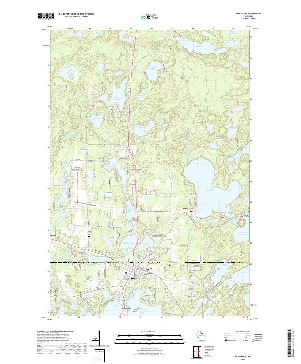 2022 Woodruff2022 Print · USGSThe Vilas and Oneida County borderlands are shown here in the modern era, centered on the growing communities of Arbor Vitae and Woodruff. Researchers can trace local heritage through several sites like Evergreen Cem or explore the shoreline of Big Arbor Vitae Lake.
 - 2023 Map of Pike Lake, 2023 Print
 2023 Pike Lake2023 Print · USGSNorthern Wisconsin's glacial lake country is documented here at the convergence of four counties within the Chequamegon National Forest. Trace the winding South Fork Flambeau River and explore the remote shorelines of Pike Lake, Tucker Lake, and Apeekwa Lake.
 - 2023 Map of Lac du Flambeau SW, 2023 Print
 2023 Lac du Flambeau SW2023 Print · USGSOneida County's dense lake country is captured in this modern survey, showing the intricate waterways between Amber Lake and Squirrel Lake. Trace the local forest road network to find places like Camp Fifteen (Spring) and the headwaters of Swamsauger Creek.
 - 2023 Map of Lac du Flambeau, 2023 Print
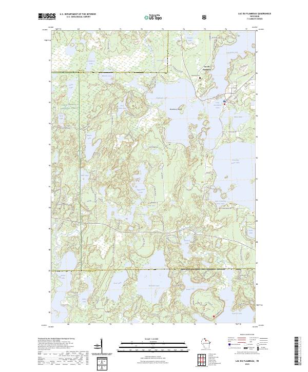 2023 Lac du Flambeau2023 Print · USGSThe interconnected waters of the Northwoods define this Vilas County region as it appeared in recent years. Researchers can trace the layout of Lac du Flambeau and locate landmarks like the Memorial Cem and Strawberry Island.
 - 2023 Map of Pike Lake SE, 2023 Print
 2023 Pike Lake SE2023 Print · USGSThe northern reaches of the Chequamegon National Forest appear in high detail at the junction of Price and Oneida Counties. Outdoor enthusiasts and local historians can trace the paths of the Price Co Snowmobile 120 Trl and identify water sources like Willow Spring and Severson Spring.
End of results
Showing maps 1-11 of 11
Top cities near Minocqua
- Lac du Flambeau historical maps
- Hazelhurst historical maps
- Lake Tomahawk historical maps
- Boulder Junction historical maps
- Fifield historical maps
- Woodruff historical maps
See more
Top neighborhoods of Minocqua
Frequently asked questions
- What are the different types of historical maps available for Minocqua?
- What is the oldest map of Minocqua?
- Where can I purchase historical maps of Minocqua for my home or office?
- Where can I download high-res historical maps of Minocqua?
- Are there historical topographic maps available for Minocqua?
- Is there historical aerial imagery available for Minocqua?
- Where are historical maps of Minocqua sourced from?