2020s Maps of Pelican, Wisconsin
Explore 6 historic maps of Pelican from the 2020s. These maps offer a rare glimpse into what life looked like during the 2020s — showing old roads, neighborhoods, homes, and landmarks that have changed or disappeared over time.
Whether you're researching your family's past, planning a metal detecting trip, or studying how Pelican's landscape evolved across the 2020s, these high-resolution maps are a powerful tool for exploring the history of this region.
- Focus on a specific era: All maps on this page are from the 2020s, giving you a focused view of this time period.
- See what’s changed: Compare century-old streets, trails, and buildings to today's modern landscape using overlays and satellite layers.
- Research with precision: Use these maps for genealogy, historical research, land use analysis, or educational projects.
- View, download, or print: Maps are fully viewable online in high resolution, and can be downloaded or printed for your own records.
Start exploring Pelican's history through authentic maps from the 2020s. This is your window into the past.
Pelican, WI maps
(6)- 2022 Map of George Lake, 2022 Print
 2022 George Lake2022 Print · USGSOneida County's lake country is captured here in the early twenty-first century, centered on the settlement of Malvern. Trace local family history and land use through named landmarks like George Lake, Little Bass Lake, and the winding Pelican River.
 - 2022 Map of Rhinelander, 2022 Print
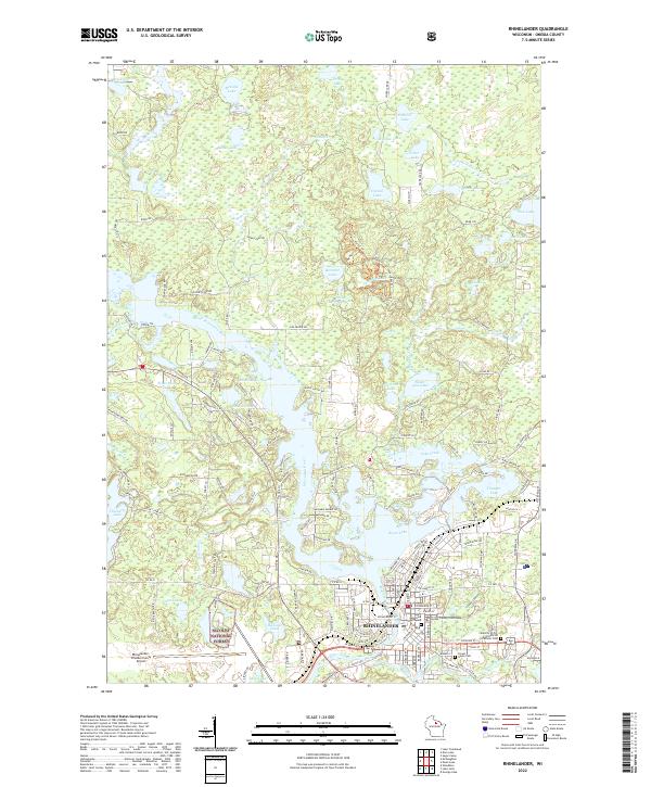 2022 Rhinelander2022 Print · USGSRhinelander and the surrounding Northwoods lake country appear here in a detailed contemporary survey. Researchers can trace the city's modern layout from the Oneida County Courthouse to the shores of Boom Lake and the Forest Home Cem.
 - 2022 Map of Monico, 2022 Print
 2022 Monico2022 Print · USGSOneida County's glacial lake country is captured here in the early twenty-first century, centered on the crossroads at Monico. Researchers can trace local heritage at Monico Cem and Schoepke Cem or explore the complex shoreline of Pelican Lake.
 - 2022 Map of Starks, 2022 Print
 2022 Starks2022 Print · USGSOneida County's Northwoods landscape is captured here in the early twenty-first century, showing a region defined by its glacial lakes and rural outposts. Researchers can locate small settlements like Starks and Gagen while tracing the waters of Stella Lake, Ginty Lake, and Starks Spring.
 - 2022 Map of Moen Lake, 2022 Print
 2022 Moen Lake2022 Print · USGSOneida County's glacial lake country is revealed here just after the turn of the twenty-first century, centered on the Moen Lake Chain. Researchers can trace the shoreline developments of Moen Lake and Lake Thompson or locate the Northland Memorial Park near Rhinelander.
 - 2023 Map of Lake Julia, 2023 Print
 2023 Lake Julia2023 Print · USGSOneida and Lincoln counties meet in this lake-rich landscape south of Rhinelander during the early 2020s. Genealogists and local historians can locate the community of Jeffris, trace the Wisconsin River corridor, and find landmarks like Nicolet Technical College.
End of results
Showing maps 1-6 of 6
Top cities near Pelican
- Rhinelander historical maps
- Newbold historical maps
- Three Lakes historical maps
- Sugar Camp historical maps
- Elcho historical maps
- Lake Tomahawk historical maps
See more
Top neighborhoods of Pelican
Frequently asked questions
- What are the different types of historical maps available for Pelican?
- What is the oldest map of Pelican?
- Where can I purchase historical maps of Pelican for my home or office?
- Where can I download high-res historical maps of Pelican?
- Are there historical topographic maps available for Pelican?
- Is there historical aerial imagery available for Pelican?
- Where are historical maps of Pelican sourced from?