1970s Maps of Union, Wisconsin
Explore 4 historic maps of Union from the 1970s. These maps offer a rare glimpse into what life looked like during the 1970s — showing old roads, neighborhoods, homes, and landmarks that have changed or disappeared over time.
Whether you're researching your family's past, planning a metal detecting trip, or studying how Union's landscape evolved across the 1970s, these high-resolution maps are a powerful tool for exploring the history of this region.
- Focus on a specific era: All maps on this page are from the 1970s, giving you a focused view of this time period.
- See what’s changed: Compare century-old streets, trails, and buildings to today's modern landscape using overlays and satellite layers.
- Research with precision: Use these maps for genealogy, historical research, land use analysis, or educational projects.
- View, download, or print: Maps are fully viewable online in high resolution, and can be downloaded or printed for your own records.
Start exploring Union's history through authentic maps from the 1970s. This is your window into the past.
Union, WI maps
(4)- 1972 Map of Plum City, 1975 Print
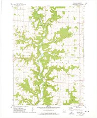
 1972 Plum City1975 Print · USGSPierce County at the start of the 1970s shows a landscape of deep coulees and ridge-top farming. Trace old family lines and local landmarks from Plum City to Exile, including Poplar Hill Cem and the waters of Nugget Lake.
 - 1972 Map of Nerike Hill, 1975 Print
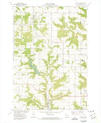
 1972 Nerike Hill1975 Print · USGSPierce and Pepin Counties in the early 1970s show a landscape of steep coulees and tight-knit rural crossroads. Researchers can trace family history through landmarks like Mission Covenant Ch, Free Home Cem, and the small settlement at Lund.
 - 1974 Map of Maiden Rock, 1978 Print
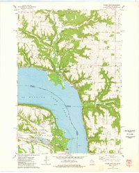 1974 Maiden Rock1978 Print · USGSThe river-and-rail corridor between Wisconsin and Minnesota is captured here during the mid-seventies, showing the deep coulees and ridges along Lake Pepin. Researchers can trace the heritage of riverside settlements like Old Frontenac and Maiden Rock or locate the historic Villa Maria Academy.
 - 1974 Map of Waverly, 1978 Print
 1974 Waverly1978 Print · USGSPierce County farm country and river valleys are captured here in the mid-1970s as agricultural life centered around small crossroads. Researchers can locate family roots near Waverly, Ono, or Bremenington and find local landmarks like Lost Creek Cem.
End of results
Showing maps 1-4 of 4
Top cities near Union
- Lake City historical maps
- Durand historical maps
- Spring Valley historical maps
- Martell historical maps
- Ellsworth historical maps
- Elmwood historical maps
See more
Top neighborhoods of Union
Frequently asked questions
- What are the different types of historical maps available for Union?
- What is the oldest map of Union?
- Where can I purchase historical maps of Union for my home or office?
- Where can I download high-res historical maps of Union?
- Are there historical topographic maps available for Union?
- Is there historical aerial imagery available for Union?
- Where are historical maps of Union sourced from?