1970s Maps of Price County, Wisconsin
Explore 21 historic maps of Price County from the 1970s. These maps offer a rare glimpse into what life looked like during the 1970s — showing old roads, neighborhoods, homes, and landmarks that have changed or disappeared over time.
Whether you're researching your family's past, planning a metal detecting trip, or studying how Price County's landscape evolved across the 1970s, these high-resolution maps are a powerful tool for exploring the history of this region.
- Focus on a specific era: All maps on this page are from the 1970s, giving you a focused view of this time period.
- See what’s changed: Compare century-old streets, trails, and buildings to today's modern landscape using overlays and satellite layers.
- Research with precision: Use these maps for genealogy, historical research, land use analysis, or educational projects.
- View, download, or print: Maps are fully viewable online in high resolution, and can be downloaded or printed for your own records.
Start exploring Price County's history through authentic maps from the 1970s. This is your window into the past.
Price County, WI maps
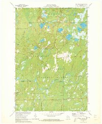
(21)- 1970 Map of Butternut Lake, 1972 Print
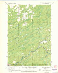
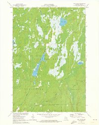
 1970 Butternut Lake1972 Print · USGSThe Price County timberlands and lakefronts are frozen in time just as the seventies began. Researchers can trace the Chicago and North Western rail route or locate local landmarks like the Kennedy Lookout Tower and Pixley Dam.
 - 1970 Map of Oxbo, 1972 Print
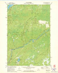
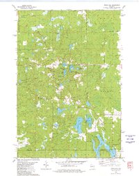
 1970 Oxbo1972 Print · USGSThe Flambeau River country comes alive in this 1970s record of Sawyer and Price counties. Trace the river's path past Barnaby Rapids and Oxbo, or locate mid-century landmarks like the Connors Lake Lookout Tower and Mason Lake Landing Field.2 unique versions available
 - 1970 Map of Jump River Fire Tower NW, 1972 Print
 1970 Jump River Fire Tower NW1972 Print · USGSThe Northwoods of Rusk and Price counties are documented here in the early 1970s, showing a landscape shaped by winding river systems and old timber routes. Trace the path of the Old Railroad Grade or locate historic recreation spots like Big Falls and Big Falls Campground.3 unique versions available
 - 1970 Map of Ogema, 1972 Print
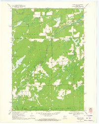
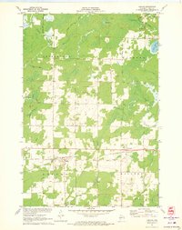
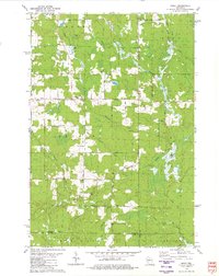
 1970 Ogema1972 Print · USGSPrice and Taylor counties come into focus in the early 1970s, centered on the millpond and rail-side settlements of the Wisconsin Northwoods. Genealogists and local historians can trace family locations along Hallstrand Road, visit Hillside Cem, or locate the old Townhall and Mackeys Spur.
 - 1970 Map of Lugerville, 1972 Print
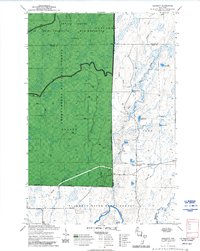
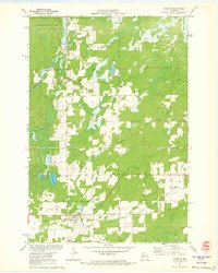
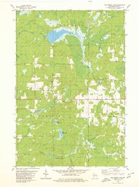
 1970 Lugerville1972 Print · USGSPrice County’s timber and river country is captured here during the early seventies, showing a landscape defined by conservation and industrial water power. Researchers can locate the Lugerville Lookout Tower, a Railroad Grade, and Niebauer Springs among the vast wetlands of the Million Acre Swamp.2 unique versions available
 - 1970 Map of Jump River Fire Tower NE, 1972 Print
 1970 Jump River Fire Tower NE1972 Print · USGSThe confluence of the Jump River forks in northern Wisconsin is captured here during the early seventies, spanning the Price and Taylor county line. Outdoorsmen and local historians can trace the bounds of the Township Corners State Wildlife Management Area and find named river landmarks like Big Falls and Steve Creek Flowage.
 - 1970 Map of Kennedy, 1972 Print
 1970 Kennedy1972 Print · USGSSawyer and Ashland counties are shown in the early 1970s as centers of Wisconsin timber and recreation. Researchers can locate the settlement of Kennedy, follow the Tuscobia State Forest Trail, and trace the shoreline of Lake Alice.3 unique versions available
 - 1970 Map of Ogema NW, 1972 Print
 1970 Ogema NW1972 Print · USGSThe river forks and rural corridors of Price County are captured here in the early seventies as the landscape transitioned into the modern era. Genealogists and historians can trace the Fourth Principal Meridian and locate landmarks like Hallberg Hill and South Fork Jump River.2 unique versions available
 - 1971 Map of Pike Lake SE, 1973 Print
 1971 Pike Lake SE1973 Print · USGSThe northern Wisconsin wilderness of Price and Oneida Counties is captured here in the early 1970s. Outdoor researchers and local historians can trace the headwaters of Foulds Creek and locate landmarks like the Lookout Tower and Steverson Spring.2 unique versions available
 - 1971 Map of Pike Lake SW, 1973 Print
 1971 Pike Lake SW1973 Print · USGSPrice County, Wisconsin, is shown here in the early 1970s, at a time when the Northwoods remained a dense expanse of timber and water. Outdoor researchers can trace the shorelines of Wilson Flowage and Riley Lake or locate early mineral sites like the local Gravel Pit.3 unique versions available
 - 1971 Map of Pike Lake, 1973 Print
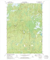
 1971 Pike Lake1973 Print · USGSIn the early 1970s, the lake country at the junction of Price, Iron, and Vilas counties was a landscape of deep forests and interconnected waterways. Researchers can trace the Chippewa Trail, locate the Lookout Tower on Sentinel Point, and explore the shorelines of Round Lake and Pike Lake.
 - 1971 Map of Kennan NW, 1973 Print
 1971 Kennan NW1973 Print · USGSSawyer County's Northwoods are captured here in the early 1970s, showcasing the winding South Fork Flambeau River and its many rapids. Researchers can locate family landmarks and recreational sites like Connors Lake, Camp Flambeau, and the Cranberry Bog.2 unique versions available
 - 1971 Map of Kennan, 1973 Print
 1971 Kennan1973 Print · USGSPrice County settlements thrived along the northern rail lines during the early seventies, centered on the villages of Kennan and Catawba. Genealogists and local historians can trace family locations through Kennan Cem, St Paul Ch, and the many family-named roads like Skinner Lane.
 - 1971 Map of Lac Sault Dore, 1973 Print
 1971 Lac Sault Dore1973 Print · USGSPrice County lake country was a mix of conservation and rural heritage in the early seventies. Genealogists and local historians can trace the Danish Settlement Road and locate landmarks like Wiemer Dam and McIlquham Lake.
 - 1971 Map of Hawkins, 1973 Print
 1971 Hawkins1973 Print · USGSRusk County in the early seventies shows a landscape of timber and rail focused on the village of Hawkins. Genealogists and local historians can trace family locations near the Hillcrest Cem, the National Ch, and the banks of the Hawkins Millpond.2 unique versions available
 - 1971 Map of Pike Lake NW, 1973 Print
 1971 Pike Lake NW1973 Print · USGSPrice and Iron counties appear here in the early seventies, dominated by the timberlands of the Chequamegon National Forest. Genealogists and outdoorsmen can trace the South Fork Flambeau River past Smith Rapids Campground and identify seasonal sites like Camp Nine Springs.3 unique versions available
 - 1979 Map of Timms Hill, 1980 Print
 1979 Timms Hill1980 Print · USGSThe Wisconsin Northwoods are captured here in the late seventies, centered on the state's highest elevation. Local historians can locate the Garden of Memory Church, trace old routes like Goetzke Road, and explore the shoreline of Spirit Lake.2 unique versions available
 - 1979 Map of Spirit, 1980 Print
 1979 Spirit1980 Print · USGSThe township of Spirit and its surrounding rural countryside are captured in the late seventies as a community of small farms and timberlands. Local historians can trace old homestead access via Settlement Road, visit the Hillcrest Cem, and locate the Old Railroad Grade near Squaw Creek.2 unique versions available
 - 1979 Map of Big Briens Lake, 1980 Print
 1979 Big Briens Lake1980 Print · USGSThe rural borderlands of Price County come into focus during the late seventies, showing the township lines of Hackett, Prentice, and Knox. Researchers can trace old family lands along Nyberg Hill Road or follow the waters of the South Fork Jump River.2 unique versions available
 - 1979 Map of Brantwood, 1980 Print
 1979 Brantwood1980 Print · USGSThe Northwoods landscape near the Price and Oneida county lines is captured here in the late seventies, centered on the Soo Line rail corridor. Genealogists and local historians can trace old homesteads and community sites like the Finnish Cem, Tripoli Sch, and the settlement of Brantwood.
 - 1979 Map of Dover, 1985 Print
 1979 Dover1985 Print · USGSPrice County in the late 1970s is shown here as a landscape of timber, wetlands, and scattered rural settlements. Researchers can trace the path of the Old Railroad Grade or locate local landmarks like the Emery Cem and the Dover Townhall.3 unique versions available
End of results
Showing maps 1-21 of 21
Top cities of Price County
- Park Falls historical maps
- Phillips historical maps
- Fifield historical maps
- Ogema historical maps
- Prentice historical maps
- Spirit historical maps
See more
Frequently asked questions
- What are the different types of historical maps available for Price County?
- What is the oldest map of Price County?
- Where can I purchase historical maps of Price County for my home or office?
- Where can I download high-res historical maps of Price County?
- Are there historical topographic maps available for Price County?
- Is there historical aerial imagery available for Price County?
- Where are historical maps of Price County sourced from?