1960s Maps of Price County, Wisconsin
Explore 4 historic maps of Price County from the 1960s. These maps offer a rare glimpse into what life looked like during the 1960s — showing old roads, neighborhoods, homes, and landmarks that have changed or disappeared over time.
Whether you're researching your family's past, planning a metal detecting trip, or studying how Price County's landscape evolved across the 1960s, these high-resolution maps are a powerful tool for exploring the history of this region.
- Focus on a specific era: All maps on this page are from the 1960s, giving you a focused view of this time period.
- See what’s changed: Compare century-old streets, trails, and buildings to today's modern landscape using overlays and satellite layers.
- Research with precision: Use these maps for genealogy, historical research, land use analysis, or educational projects.
- View, download, or print: Maps are fully viewable online in high resolution, and can be downloaded or printed for your own records.
Start exploring Price County's history through authentic maps from the 1960s. This is your window into the past.
Price County, WI maps
(4)- 1968 Map of Phillips, 1970 Print
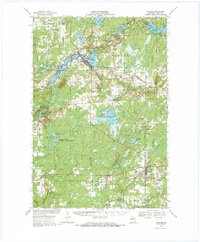 1968 Phillips1970 Print · USGSPrice County's lake-rich timberlands are documented here in the late sixties, centered on the city of Phillips. Researchers can trace family history through sites like Lakeside Cem, the Worcester Sch, and the SOO LINE railroad route.2 unique versions available
 - 1968 Map of Park Falls, 1971 Print
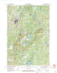 1968 Park Falls1971 Print · USGSPark Falls and Fifield sit at the heart of the northern timber country in the late sixties, where the Flambeau River meets a dense network of rail lines. Researchers can trace historic logging routes like the SMITH GRADE or locate local landmarks such as Nola Cem and Solberg Lake County Park.2 unique versions available
 - 1968 Map of Park Falls SE, 1985 Print
 1968 Park Falls SE1985 Print · USGSPrice County, Wisconsin, in the late sixties reveals a landscape of extensive forest management and protected wetlands. Outdoorsmen and local historians can trace the development of the Sailor Lake Campground and the marshy expanses of the Schmuland Waterfowl Area.
 - 1968 Map of Park Falls NE, 1985 Print
 1968 Park Falls NE1985 Print · USGSThe Flambeau River wilderness in Price County is captured here in the late sixties, highlighting the deep integration of forestry and recreation. Researchers can trace the layout of the Wintergreen Ski Trails and find landmarks like Sugarbush Dam and Blockhouse Lake.
End of results
Showing maps 1-4 of 4
Top cities of Price County
- Park Falls historical maps
- Phillips historical maps
- Fifield historical maps
- Ogema historical maps
- Prentice historical maps
- Spirit historical maps
See more
Frequently asked questions
- What are the different types of historical maps available for Price County?
- What is the oldest map of Price County?
- Where can I purchase historical maps of Price County for my home or office?
- Where can I download high-res historical maps of Price County?
- Are there historical topographic maps available for Price County?
- Is there historical aerial imagery available for Price County?
- Where are historical maps of Price County sourced from?