1980s Maps of Fifield, Wisconsin
Explore 5 historic maps of Fifield from the 1980s. These maps offer a rare glimpse into what life looked like during the 1980s — showing old roads, neighborhoods, homes, and landmarks that have changed or disappeared over time.
Whether you're researching your family's past, planning a metal detecting trip, or studying how Fifield's landscape evolved across the 1980s, these high-resolution maps are a powerful tool for exploring the history of this region.
- Focus on a specific era: All maps on this page are from the 1980s, giving you a focused view of this time period.
- See what’s changed: Compare century-old streets, trails, and buildings to today's modern landscape using overlays and satellite layers.
- Research with precision: Use these maps for genealogy, historical research, land use analysis, or educational projects.
- View, download, or print: Maps are fully viewable online in high resolution, and can be downloaded or printed for your own records.
Start exploring Fifield's history through authentic maps from the 1980s. This is your window into the past.
Fifield, WI maps
(5)- 1980 Map of Park Falls
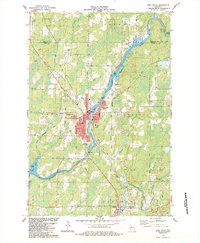
 1980 Park Falls1980 Print · USGSNorthern Wisconsin's timber and rail corridor is meticulously detailed here in the early eighties. Researchers can trace the Soo Line through forest-bound towns like Park Falls, Phillips, and Lugerville while exploring the vast Chequamegon National Forest.
 - 1984 Map of Park Falls
 1984 Park Falls1984 Print · USGSPark Falls and the surrounding Northwoods landscape appear here during the mid-eighties, centered on the river's industrial power. Researchers can trace the Soo Line rail corridor, locate Nola Cem, and explore the settlement at Lymantown.
 - 1984 Map of Blockhouse Lake
 1984 Blockhouse Lake1984 Print · USGSNorthern Wisconsin's timberlands and river systems are shown in great detail during the 1980s. You can trace the winding South Fork Flambeau River past Sugarbush Dam and locate secluded camps near Blockhouse Lake and Iodine Lake.
 - 1984 Map of Priest Lake
 1984 Priest Lake1984 Print · USGSPrice County townships Fifield and Worcester are captured in the mid-1980s as the river-driven landscape continues its transition to a recreation-based economy. Genealogists and historians can trace family landmarks and remote sites like Holy Cross King of Martyrs Priory, Nutting No 2, and the portages at Rocky Carry Rapids.
 - 1984 Map of Gates Lake
 1984 Gates Lake1984 Print · USGSPrice County timberlands and glacial lakes are captured here in the mid-1980s as the national forest boundary encompasses a landscape of water and woods. Trace local landmarks like Hicks Landing, the Cranberry Bog, and Solberg Lake County Park.
End of results
Showing maps 1-5 of 5
Top cities near Fifield
- Minocqua historical maps
- Lac du Flambeau historical maps
- Park Falls historical maps
- Mercer historical maps
- Phillips historical maps
- Butternut historical maps
Frequently asked questions
- What are the different types of historical maps available for Fifield?
- What is the oldest map of Fifield?
- Where can I purchase historical maps of Fifield for my home or office?
- Where can I download high-res historical maps of Fifield?
- Are there historical topographic maps available for Fifield?
- Is there historical aerial imagery available for Fifield?
- Where are historical maps of Fifield sourced from?