1970s Maps of Rusk County, Wisconsin
Explore 28 historic maps of Rusk County from the 1970s. These maps offer a rare glimpse into what life looked like during the 1970s — showing old roads, neighborhoods, homes, and landmarks that have changed or disappeared over time.
Whether you're researching your family's past, planning a metal detecting trip, or studying how Rusk County's landscape evolved across the 1970s, these high-resolution maps are a powerful tool for exploring the history of this region.
- Focus on a specific era: All maps on this page are from the 1970s, giving you a focused view of this time period.
- See what’s changed: Compare century-old streets, trails, and buildings to today's modern landscape using overlays and satellite layers.
- Research with precision: Use these maps for genealogy, historical research, land use analysis, or educational projects.
- View, download, or print: Maps are fully viewable online in high resolution, and can be downloaded or printed for your own records.
Start exploring Rusk County's history through authentic maps from the 1970s. This is your window into the past.
Rusk County, WI maps
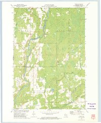
(28)- 1970 Map of Jump River Fire Tower NW, 1972 Print
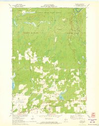
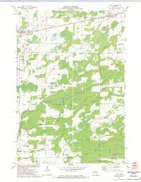
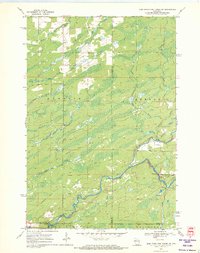 1970 Jump River Fire Tower NW1972 Print · USGSThe Northwoods of Rusk and Price counties are documented here in the early 1970s, showing a landscape shaped by winding river systems and old timber routes. Trace the path of the Old Railroad Grade or locate historic recreation spots like Big Falls and Big Falls Campground.3 unique versions available
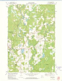
 - 1971 Map of Big Falls Dam, 1973 Print
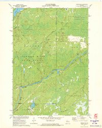
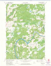
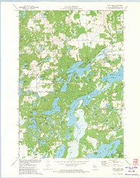
 1971 Big Falls Dam1973 Print · USGSThe Flambeau River dominates this Rusk County landscape during the early 1970s as it transitions from wild rapids to managed flowages. Researchers can trace the local community through the Glenview Cem, the Swedish Cem, and the settlement at Glen Flora.2 unique versions available
 - 1971 Map of Kennan NW, 1973 Print
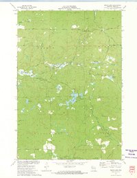
 1971 Kennan NW1973 Print · USGSSawyer County's Northwoods are captured here in the early 1970s, showcasing the winding South Fork Flambeau River and its many rapids. Researchers can locate family landmarks and recreational sites like Connors Lake, Camp Flambeau, and the Cranberry Bog.2 unique versions available
 - 1971 Map of Ingram NE, 1973 Print
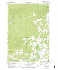
 1971 Ingram NE1973 Print · USGSSawyer County's northern timberlands are captured in the early 1970s, dominated by the winding river corridor and legacy logging routes. Researchers can trace the path of the Old Railroad Grade or locate numerous river features like Flambeau Falls Rapids and Dades Island.2 unique versions available
 - 1971 Map of Ladysmith, 1973 Print
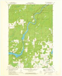
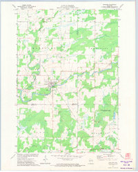
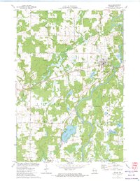
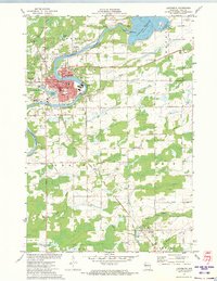 1971 Ladysmith1973 Print · USGSRusk County's river-and-rail landscape is captured here in the early seventies, centered on the growth of Ladysmith. Researchers can trace the mid-century city layout, from Mt Senario College to family landmarks like Riverside Cemetery and Conrath.
 - 1971 Map of Hawkins, 1973 Print
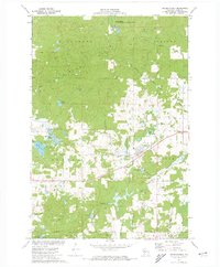
 1971 Hawkins1973 Print · USGSRusk County in the early seventies shows a landscape of timber and rail focused on the village of Hawkins. Genealogists and local historians can trace family locations near the Hillcrest Cem, the National Ch, and the banks of the Hawkins Millpond.2 unique versions available
 - 1971 Map of Ingram, 1973 Print
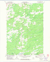
 1971 Ingram1973 Print · USGSNorthern Wisconsin timber and rail country come alive in this early 1970s survey of Rusk County. Trace the industrial footprint through Ingram and follow the Soo Line tracks or the high vantage point of the Ladd Creek Lookout Tower.
 - 1971 Map of Ingram NW, 1973 Print
 1971 Ingram NW1973 Print · USGSSawyer County in the early 1970s is a landscape of dense forests and river networks just as modern conservation boundaries were being solidified. You can trace old logging routes like the Bissell Grade and locate historical sites such as Old Weaver Camp and Hay-Stack Corner.2 unique versions available
 - 1971 Map of Thornapple, 1973 Print
 1971 Thornapple1973 Print · USGSRusk County at the start of the seventies shows a landscape where industrial transit and river management converge. Researchers can trace the Old Railroad Grade and Soo Line tracks near the Thornapple Dam and Port Arthur.
 - 1971 Map of Ladysmith SE, 1974 Print
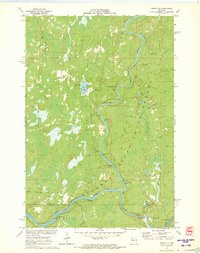
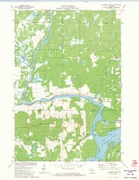
 1971 Ladysmith SE1974 Print · USGSThe Jump River valley underwent significant change in the early seventies following the Holcombe power project. Trace the new shoreline of the Jump River Flowage and locate landmarks like the Willard Sch Townhall and Paradise Point.
 - 1971 Map of Sheldon, 1974 Print
 1971 Sheldon1974 Print · USGSSheldon and Donald are shown in the early 1970s at the junction of the Jump and Little Jump Rivers. Local researchers can trace community landmarks like the Mennonite Ch, the Fairground, and the path of the SOO LINE RAILROAD.
 - 1971 Map of Flambeau Ridge, 1974 Print
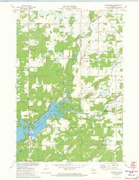
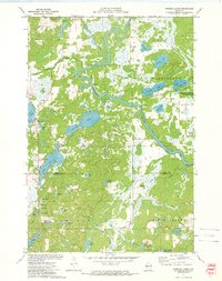
 1971 Flambeau Ridge1974 Print · USGSThe confluence of the Flambeau and Chippewa Rivers in northern Wisconsin is captured here during the early seventies. Local historians can trace lakeside developments and landmarks like St Francis Ch, the Flambeau Lookout Tower, and Pine Island.
 - 1971 Map of Tony, 1974 Print
 1971 Tony1974 Print · USGSThe railroad towns of Tony and Glen Flora anchor this Rusk County landscape in the early 1970s, where the SOO LINE tracks cut across a dense network of river forks. Local researchers can trace rural developments along Progressive Road and the many branches of Main Creek.2 unique versions available
 - 1971 Map of Sheldon NE, 1974 Print
 1971 Sheldon NE1974 Print · USGSRusk and Taylor Counties in the early 1970s reveal a landscape of winding river systems and small civic outposts. Genealogists and local historians can locate the South Lawrence Cemetery, the Townhall, and traces of an Old Railroad Grade.
 - 1972 Map of Fireside Lakes, 1974 Print
 1972 Fireside Lakes1974 Print · USGSThe Chippewa River valley straddles the Rusk and Chippewa County line in the early seventies, a landscape of dense woods and glacial kettle lakes. Genealogists and local historians can trace the rural layout of Big Bend through sites like the Mud Lake Cem, Island Lake Ch, and Hatch Landing.
 - 1972 Map of Bruce, 1974 Print
 1972 Bruce1974 Print · USGSRusk County at the start of the 1970s shows a landscape shaped by the Chippewa River and the steady presence of the Soo Line railroad. Local historians can trace family roots through sites like St Marys Cem or locate old community centers in Bruce and Apollonia.
 - 1972 Map of Chain Lake, 1974 Print
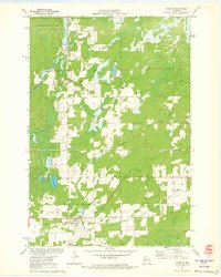
 1972 Chain Lake1974 Print · USGSThe Northwoods of Wisconsin are captured in the early seventies, showcasing a dense network of glacial lakes and wilderness along the Rusk and Chippewa county line. Researchers can trace remote campsites like Two Bear Camp and local landmarks like Stang Lookout Tower or the Townhall.
 - 1972 Map of Weyerhauser, 1974 Print
 1972 Weyerhauser1974 Print · USGSRusk County at the start of the 1970s is a landscape of glacial hills and timbered wetlands centered on the railroad village of Weyerhauser. Genealogists and local historians can trace family roots at the Polish Cem or locate old homesteads along Norwegian Road and McDermott Rd.
 - 1972 Map of Bucks Lake, 1974 Print
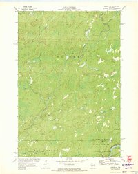
 1972 Bucks Lake1974 Print · USGSRusk County’s rugged northern timberlands are captured here in the early 1970s, showing a landscape of managed flowages and conservation areas. Researchers can locate the Blue Hills Lookout Tower, the local Townhall, and primitive tracks like Serley Camp Trail.
 - 1972 Map of Becky Creek, 1975 Print
 1972 Becky Creek1975 Print · USGSRusk County's timberlands and drainage basins are captured here during the early seventies, showing a landscape defined by industrial logging remnants and small settlements. Researchers can trace the Old Railroad Grade, locate the Blue Hills Cem, and find the hamlet of Adams.2 unique versions available
 - 1972 Map of Crane, 1975 Print
 1972 Crane1975 Print · USGSRusk County’s river valleys and rail corridors are captured in the early seventies as small communities and rural industries shaped the landscape. Genealogists and local historians can locate St Anns Ch, the Townhall, and old rail paths like the Old RR Grade.
 - 1972 Map of Hogsback Creek, 1975 Print
 1972 Hogsback Creek1975 Print · USGSNorthern Wisconsin’s timber and rail history is visible in the early seventies across the Sawyer and Rusk county line. Trace legacy transport routes like the Bissell Grade and the Old Railroad Grade alongside Hogsback Creek.
 - 1972 Map of Edgewater, 1975 Print
 1972 Edgewater1975 Print · USGSSawyer County at the start of the 1970s shows a landscape of deep-water bays and northwoods trails. Genealogists and historians can trace the Old Railroad Grade past Yarnell or locate family sites near Edgewater and Wooddale.
 - 1972 Map of Weirgor, 1975 Print
 1972 Weirgor1975 Print · USGSSawyer and Rusk Counties are captured in the early seventies, showing a landscape shaped by the Soo Line and the Meteor Hills. Researchers can trace old foundations near Meteor or explore the Weirgor Springs State Wildlife Area.
 - 1972 Map of Exeland, 1975 Print
 1972 Exeland1975 Print · USGSSawyer County life in the early seventies centered on the river junctions and the rails of the Soo Line Railroad. You can trace local family landmarks and burial sites like the Bellile Cem, Mennonite Cem, and the village at Exeland.
Showing maps 1-25 of 28
Top cities of Rusk County
- Ladysmith historical maps
- Thornapple historical maps
- Bruce historical maps
- Weyerhaeuser historical maps
- Hawkins historical maps
- Strickland historical maps
See more
Frequently asked questions
- What are the different types of historical maps available for Rusk County?
- What is the oldest map of Rusk County?
- Where can I purchase historical maps of Rusk County for my home or office?
- Where can I download high-res historical maps of Rusk County?
- Are there historical topographic maps available for Rusk County?
- Is there historical aerial imagery available for Rusk County?
- Where are historical maps of Rusk County sourced from?