1970s Maps of Hubbard, Wisconsin
Explore 4 historic maps of Hubbard from the 1970s. These maps offer a rare glimpse into what life looked like during the 1970s — showing old roads, neighborhoods, homes, and landmarks that have changed or disappeared over time.
Whether you're researching your family's past, planning a metal detecting trip, or studying how Hubbard's landscape evolved across the 1970s, these high-resolution maps are a powerful tool for exploring the history of this region.
- Focus on a specific era: All maps on this page are from the 1970s, giving you a focused view of this time period.
- See what’s changed: Compare century-old streets, trails, and buildings to today's modern landscape using overlays and satellite layers.
- Research with precision: Use these maps for genealogy, historical research, land use analysis, or educational projects.
- View, download, or print: Maps are fully viewable online in high resolution, and can be downloaded or printed for your own records.
Start exploring Hubbard's history through authentic maps from the 1970s. This is your window into the past.
Hubbard, WI maps
(4)- 1972 Map of Crane, 1975 Print
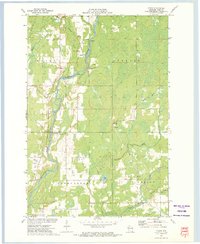 1972 Crane1975 Print · USGSRusk County’s river valleys and rail corridors are captured in the early seventies as small communities and rural industries shaped the landscape. Genealogists and local historians can locate St Anns Ch, the Townhall, and old rail paths like the Old RR Grade.
 - 1972 Map of Hogsback Creek, 1975 Print
 1972 Hogsback Creek1975 Print · USGSNorthern Wisconsin’s timber and rail history is visible in the early seventies across the Sawyer and Rusk county line. Trace legacy transport routes like the Bissell Grade and the Old Railroad Grade alongside Hogsback Creek.
 - 1972 Map of Exeland, 1975 Print
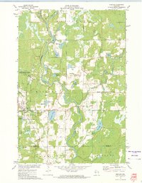 1972 Exeland1975 Print · USGSSawyer County life in the early seventies centered on the river junctions and the rails of the Soo Line Railroad. You can trace local family landmarks and burial sites like the Bellile Cem, Mennonite Cem, and the village at Exeland.
 - 1972 Map of Exeland SE, 1975 Print
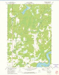 1972 Exeland SE1975 Print · USGSRusk County at the start of the 1970s showcases a landscape of active water management and rural community life. Researchers can locate the Round Meadow Community Club, trace the OLD RR GRADE, and see the early layout of the Rusk County Airport.
End of results
Showing maps 1-4 of 4
Top cities near Hubbard
- Ladysmith historical maps
- Thornapple historical maps
- Bruce historical maps
- Weirgor historical maps
- Winter historical maps
- Ojibwa historical maps
See more
Frequently asked questions
- What are the different types of historical maps available for Hubbard?
- What is the oldest map of Hubbard?
- Where can I purchase historical maps of Hubbard for my home or office?
- Where can I download high-res historical maps of Hubbard?
- Are there historical topographic maps available for Hubbard?
- Is there historical aerial imagery available for Hubbard?
- Where are historical maps of Hubbard sourced from?