1970s Maps of True, Wisconsin
Explore 4 historic maps of True from the 1970s. These maps offer a rare glimpse into what life looked like during the 1970s — showing old roads, neighborhoods, homes, and landmarks that have changed or disappeared over time.
Whether you're researching your family's past, planning a metal detecting trip, or studying how True's landscape evolved across the 1970s, these high-resolution maps are a powerful tool for exploring the history of this region.
- Focus on a specific era: All maps on this page are from the 1970s, giving you a focused view of this time period.
- See what’s changed: Compare century-old streets, trails, and buildings to today's modern landscape using overlays and satellite layers.
- Research with precision: Use these maps for genealogy, historical research, land use analysis, or educational projects.
- View, download, or print: Maps are fully viewable online in high resolution, and can be downloaded or printed for your own records.
Start exploring True's history through authentic maps from the 1970s. This is your window into the past.
True, WI maps
(4)- 1971 Map of Big Falls Dam, 1973 Print
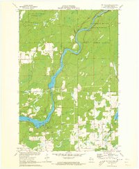 1971 Big Falls Dam1973 Print · USGSThe Flambeau River dominates this Rusk County landscape during the early 1970s as it transitions from wild rapids to managed flowages. Researchers can trace the local community through the Glenview Cem, the Swedish Cem, and the settlement at Glen Flora.2 unique versions available
 - 1971 Map of Ingram, 1973 Print
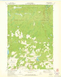 1971 Ingram1973 Print · USGSNorthern Wisconsin timber and rail country come alive in this early 1970s survey of Rusk County. Trace the industrial footprint through Ingram and follow the Soo Line tracks or the high vantage point of the Ladd Creek Lookout Tower.
 - 1971 Map of Tony, 1974 Print
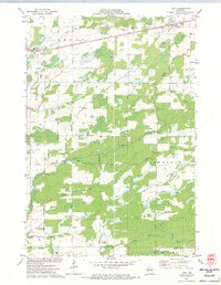 1971 Tony1974 Print · USGSThe railroad towns of Tony and Glen Flora anchor this Rusk County landscape in the early 1970s, where the SOO LINE tracks cut across a dense network of river forks. Local researchers can trace rural developments along Progressive Road and the many branches of Main Creek.2 unique versions available
 - 1971 Map of Sheldon NE, 1974 Print
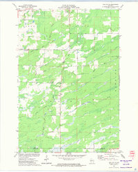 1971 Sheldon NE1974 Print · USGSRusk and Taylor Counties in the early 1970s reveal a landscape of winding river systems and small civic outposts. Genealogists and local historians can locate the South Lawrence Cemetery, the Townhall, and traces of an Old Railroad Grade.
End of results
Showing maps 1-4 of 4
Top cities near True
- Ladysmith historical maps
- Westboro historical maps
- Ruby historical maps
- Jump River historical maps
- Hawkins historical maps
- Sheldon historical maps
See more
Frequently asked questions
- What are the different types of historical maps available for True?
- What is the oldest map of True?
- Where can I purchase historical maps of True for my home or office?
- Where can I download high-res historical maps of True?
- Are there historical topographic maps available for True?
- Is there historical aerial imagery available for True?
- Where are historical maps of True sourced from?