1960s Maps of Sauk County, Wisconsin
Explore 11 historic maps of Sauk County from the 1960s. These maps offer a rare glimpse into what life looked like during the 1960s — showing old roads, neighborhoods, homes, and landmarks that have changed or disappeared over time.
Whether you're researching your family's past, planning a metal detecting trip, or studying how Sauk County's landscape evolved across the 1960s, these high-resolution maps are a powerful tool for exploring the history of this region.
- Focus on a specific era: All maps on this page are from the 1960s, giving you a focused view of this time period.
- See what’s changed: Compare century-old streets, trails, and buildings to today's modern landscape using overlays and satellite layers.
- Research with precision: Use these maps for genealogy, historical research, land use analysis, or educational projects.
- View, download, or print: Maps are fully viewable online in high resolution, and can be downloaded or printed for your own records.
Start exploring Sauk County's history through authentic maps from the 1960s. This is your window into the past.
Sauk County, WI maps
(11)- 1960 Map of Madison
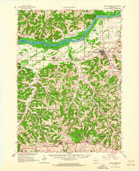
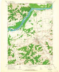
 1960 Madison1960 Print · USGSCentral and Southern Wisconsin are captured in the late fifties, showing the region as its rail-and-river network matured. Trace the paths of the Soo Line RR or locate family roots near Lake Mendota and Horicon National Wildlife Refuge.2 unique versions available
 - 1960 Map of Plain, 1961 Print
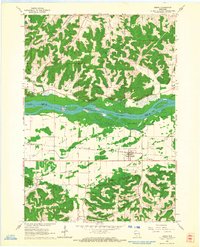
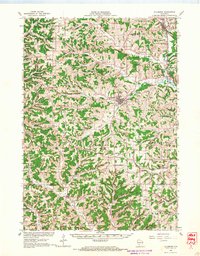
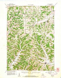 1960 Plain1961 Print · USGSCentral Sauk County and eastern Richland County appear here in the early sixties, characterized by a dense network of hill-country hollows and rural settlements. Family historians can trace rural school districts like Puckertown Sch and Hickory Grove Sch or locate the Our Lady of the Fields Chapel.2 unique versions available
 - 1960 Map of Spring Green, 1962 Print
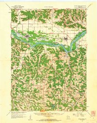 1960 Spring Green1962 Print · USGSThe Wisconsin River valley and surrounding Driftless Area uplands are captured here in the early sixties. Researchers can trace rural lineages through numerous country landmarks like Unity Chapel, Gold Mine Sch, and the quiet crossroads at Clyde.2 unique versions available
 - 1961 Map of La Crosse
 1961 La Crosse1961 Print · USGSThe Driftless Area at the start of the 1960s reveals a complex network of river towns and rail lines along the Mississippi River. Genealogists and historians can trace old settlements like New Amsterdam and Wyattville or locate major landmarks like Camp McCoy Military Reservation and Effigy Mounds National Monument.
 - 1962 Map of Cross Plains, 1964 Print
 1962 Cross Plains1964 Print · USGSWestern Dane County in the early sixties shows a landscape of deep valleys and rising ridges between Cross Plains and Mt Horeb. Genealogists and historians can trace family locations through numerous rural sites like St Marys Cem, Richardson Cave, and the Pine Bluff Observatory.2 unique versions available
 - 1962 Map of Black Earth, 1964 Print
 1962 Black Earth1964 Print · USGSDane County's ridge-and-valley landscape is documented here in the early sixties, showing the rural crossroads and rail corridors of the Driftless Area. You can locate family history at St Johns Ch or trace the old rail line near Black Earth and Table Bluff.2 unique versions available
 - 1962 Map of Blue Mounds, 1964 Print
 1962 Blue Mounds1964 Print · USGSThe Wisconsin River valley and the driftless hills of Dane County are captured here in the early sixties. Genealogists and hikers can trace old ridge roads to Little Norway, the White Church Cem, and the underground wonders of Cave of the Mounds.3 unique versions available
 - 1962 Map of Mazomanie, 1964 Print
 1962 Mazomanie1964 Print · USGSThe Wisconsin River valley comes alive in the early sixties, showing the vital rail-and-river connection between local settlements. Genealogists and historians can locate St Barnabas Ch, the Cassell Cem, and the tracks of the Chicago Milwaukee St Paul and Pacific railroad.3 unique versions available
 - 1962 Map of Arena, 1964 Print
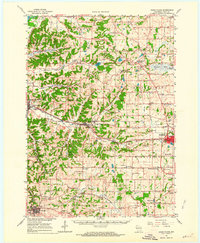
 1962 Arena1964 Print · USGSIowa and Sauk Counties are captured in the early sixties as the rail-and-river economy defined local life. Researchers can trace family roots at Arena Cem and Davis Cem or locate old landmarks like Coon Rock Cave and Cassell.2 unique versions available
 - 1965 Map of La Crosse
 1965 La Crosse1965 Print · USGSThe Driftless Area and the Upper Mississippi valley are captured here during a period of steady mid-century growth. Researchers can trace the rail lines of the Chicago and North Western or locate riverfront sites like Effigy Mounds National Monument and the Camp McCoy Military Reservation.
 - 1966 Map of Hillsboro, 1968 Print
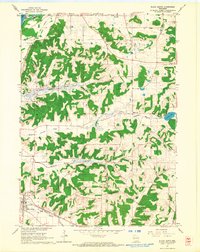
 1966 Hillsboro1968 Print · USGSWisconsin's Driftless Area remains a maze of ridges and coulees in the mid-sixties, centered on the growing town of Hillsboro. Genealogists can locate family roots at the Bohemian Brotherhood Cem, County Corners Sch, or along the Chicago and North Western line.
End of results
Showing maps 1-11 of 11
Top cities of Sauk County
- Baraboo historical maps
- Reedsburg historical maps
- Prairie du Sac historical maps
- Lake Delton historical maps
- Sauk City historical maps
- West Baraboo historical maps
See more
Frequently asked questions
- What are the different types of historical maps available for Sauk County?
- What is the oldest map of Sauk County?
- Where can I purchase historical maps of Sauk County for my home or office?
- Where can I download high-res historical maps of Sauk County?
- Are there historical topographic maps available for Sauk County?
- Is there historical aerial imagery available for Sauk County?
- Where are historical maps of Sauk County sourced from?