1980s Maps of Sauk County, Wisconsin
Explore 11 historic maps of Sauk County from the 1980s. These maps offer a rare glimpse into what life looked like during the 1980s — showing old roads, neighborhoods, homes, and landmarks that have changed or disappeared over time.
Whether you're researching your family's past, planning a metal detecting trip, or studying how Sauk County's landscape evolved across the 1980s, these high-resolution maps are a powerful tool for exploring the history of this region.
- Focus on a specific era: All maps on this page are from the 1980s, giving you a focused view of this time period.
- See what’s changed: Compare century-old streets, trails, and buildings to today's modern landscape using overlays and satellite layers.
- Research with precision: Use these maps for genealogy, historical research, land use analysis, or educational projects.
- View, download, or print: Maps are fully viewable online in high resolution, and can be downloaded or printed for your own records.
Start exploring Sauk County's history through authentic maps from the 1980s. This is your window into the past.
Sauk County, WI maps
(11)- 1983 Map of Lime Ridge
 1983 Lime Ridge1983 Print · USGSRichland and Sauk Counties are captured in the early eighties as a patchwork of small dairy farms and rural townships. Genealogists and local historians can trace family roots through numerous sites like St Pauls Cem, the settlement of Sandusky, and Weston High Sch.
 - 1983 Map of Loganville
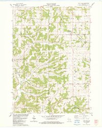
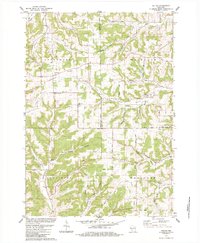
 1983 Loganville1983 Print · USGSSauk County in the early eighties shows a settled landscape of family farms and rural parishes. Researchers can trace historic local boundaries and find sites like Tuckertown Cem, the County Home, and the winding Narrows Creek.
 - 1983 Map of Lone Rock
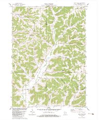
 1983 Lone Rock1983 Print · USGSRichland County's riverfront and the bluffs of the Driftless Area are captured here in the early eighties. Researchers can trace the rail lines of the Chicago Milwaukee St Paul and Pacific or locate rural sites like Dixon Sch and Lone Rock Cem.
 - 1983 Map of Bear Valley
 1983 Bear Valley1983 Print · USGSSauk and Richland Counties are shown in the early eighties as a landscape of deep hollows and high ridges. Researchers can locate family landmarks such as St Killian Ch, the Ward Cem, and the industrial site of the Marble Quarry.
 - 1983 Map of Spring Green
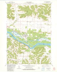
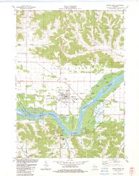 1983 Spring Green1983 Print · USGSThe Wisconsin River valley in the early eighties shows a landscape defined by braided waterways and cultural landmarks. Genealogists can locate family sites like Old Helena Cem and Big Hollow Cem, or trace the grounds of Taliesin and Hillside Sch.
 - 1983 Map of Plain
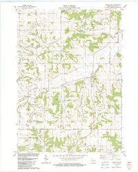
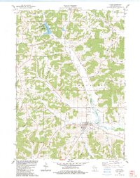 1983 Plain1983 Print · USGSIn the early 1980s, the village of Plain and the surrounding township of Franklin reveal a landscape of steep valleys and rural homesteads. Genealogists and local historians can trace family locations through St Lukes Cem, Whitemound Cem, and the notable St Anna Shrine.
 - 1983 Map of Valton, 1984 Print
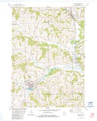
 1983 Valton1984 Print · USGSThe tri-county border of Richland, Vernon, and Sauk counties comes into focus in the early 1980s, showcasing a landscape of high ridges and rural valleys. Researchers can trace family history at St Patricks Ch or locate family-named features like Benders Corners and Soules Creek.
 - 1983 Map of Hillsboro, 1984 Print
 1983 Hillsboro1984 Print · USGSWisconsin’s driftless landscape at the start of the 1980s reveals a network of river-valley towns connected by rail and ridge roads. Genealogists and local historians can trace rural roots through St Patricks Cem, Hills Prairie Cem, and landmarks like Tinkers Bluff.
 - 1985 Map of Wisconsin Dells
 1985 Wisconsin Dells1985 Print · USGSCentral Wisconsin in the mid-eighties was a landscape of intricate river bends, rail junctions, and sprawling marshlands. Researchers can trace historic routes along the Soo Line or locate family landmarks near Lyndon Station, Buffalo Lake, and Puckaway Lake.
 - 1985 Map of Sparta
 1985 Sparta1985 Print · USGSWestern Wisconsin in the 1980s shows the unique ridge-and-valley terrain of the Driftless Area during a period of transition for its rails and rural hubs. Trace the historic rail tunnels of the Elroy-Sparta State Trail and find local landmarks like St Marys Ch and Castle Rock Lake.2 unique versions available
 - 1985 Map of Richland Center, 1991 Print
 1985 Richland Center1991 Print · USGSSouthwest Wisconsin’s driftless landscape in the mid-1980s is defined by its deep river valleys and tight agricultural settlements. Researchers can trace family-named landmarks like Mickelson Ridge or find remote churches and schools near Richland Center and Dodgeville.
End of results
Showing maps 1-11 of 11
Top cities of Sauk County
- Baraboo historical maps
- Reedsburg historical maps
- Prairie du Sac historical maps
- Lake Delton historical maps
- Sauk City historical maps
- West Baraboo historical maps
See more
Frequently asked questions
- What are the different types of historical maps available for Sauk County?
- What is the oldest map of Sauk County?
- Where can I purchase historical maps of Sauk County for my home or office?
- Where can I download high-res historical maps of Sauk County?
- Are there historical topographic maps available for Sauk County?
- Is there historical aerial imagery available for Sauk County?
- Where are historical maps of Sauk County sourced from?