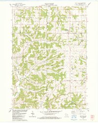
1983 Map of Lime Ridge
USGS Topo · Published 1983About this map
The rolling agricultural landscape of Richland and Sauk Counties is meticulously detailed in this early 1980s record, revealing a dense network of township roads and family-named landmarks. The village of Lime Ridge stands as a central hub, while the surrounding townships of Westford, Ironton, and Washington are dotted with rural institutions including Weston High Sch and Pine Crest Sch. The map reveals a high concentration of cemeteries such as Concord Cem and Big Willow Cem, which, along with the numerous active quarries, indicate the region's historical reliance on both farming and mineral extraction.
Find a feature on this map
53 named features on this map. Tap any name to fly to it.
Don’t see what you’re looking for? This feature index may not catch every label — zoom into the map to look around manually.
Map Details
Editions of this 1983 Lime Ridge Map
This is the sole edition of this map. No revisions or reprints were ever made.
Other maps of this area

1905 · Richland Center
USGS Topo · 1:125,000

1927 · Hillsboro
USGS Topo · 1:62,500

1956 · Reedsburg
USGS Topo · 1:62,500

1958 · La Crosse
USGS Topo · 1:250,000

1960 · Richland Center
USGS Topo · 1:62,500

1960 · Plain
USGS Topo · 1:62,500

1961 · La Crosse
USGS Topo · 1:250,000

1965 · La Crosse
USGS Topo · 1:250,000

1966 · Hillsboro
USGS Topo · 1:62,500
1975 · Reedsburg West
USGS Topo · 1:24,000