
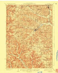
1927 Map of Hillsboro
USGS Topo · Published 1927About this map
Hillsboro serves as the central hub of this 1920s landscape, situated at the confluence of the South Fork Baraboo River and the Branch. The map reveals a dense network of rural infrastructure, where nearly every ridge and valley is anchored by a neighborhood schoolhouse, such as the Mayflower School or Whiteoak Grove School. These small institutions, along with houses of worship like Union Church and Beaver Valley Church, delineate the social geography of Vernon, Monroe, and Richland counties during this period of agrarian stability.
Find a feature on this map
103 named features on this map. Tap any name to fly to it.
Don’t see what you’re looking for? This feature index may not catch every label — zoom into the map to look around manually.
Map Details
Editions of this 1927 Hillsboro Map
2 editions found
Other maps of this area

1905 · Richland Center
USGS Topo · 1:125,000

1916 · Tomah
USGS Topo · 1:62,500

1919 · Kendall
USGS Topo · 1:62,500

1921 · Mauston
USGS Topo · 1:62,500

1921 · Kendall
USGS Topo · 1:62,500

1926 · La Farge
USGS Topo · 1:62,500

1933 · Boaz
USGS Topo · 1:62,500

1949 · Tomah
USGS Topo · 1:62,500

1956 · Reedsburg
USGS Topo · 1:62,500

1958 · La Crosse
USGS Topo · 1:250,000