1970s Maps of Sauk County, Wisconsin
Explore 23 historic maps of Sauk County from the 1970s. These maps offer a rare glimpse into what life looked like during the 1970s — showing old roads, neighborhoods, homes, and landmarks that have changed or disappeared over time.
Whether you're researching your family's past, planning a metal detecting trip, or studying how Sauk County's landscape evolved across the 1970s, these high-resolution maps are a powerful tool for exploring the history of this region.
- Focus on a specific era: All maps on this page are from the 1970s, giving you a focused view of this time period.
- See what’s changed: Compare century-old streets, trails, and buildings to today's modern landscape using overlays and satellite layers.
- Research with precision: Use these maps for genealogy, historical research, land use analysis, or educational projects.
- View, download, or print: Maps are fully viewable online in high resolution, and can be downloaded or printed for your own records.
Start exploring Sauk County's history through authentic maps from the 1970s. This is your window into the past.
Sauk County, WI maps
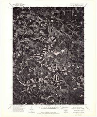
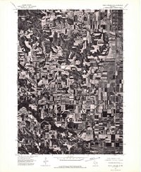
(23)- 1974 Map of Baraboo SE, 1976 Print
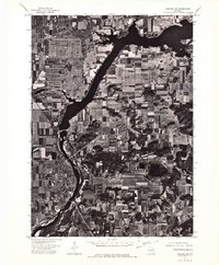
 1974 Baraboo SE1976 Print · USGSThe river valley and surrounding farmsteads are captured in this mid-1970s aerial survey as the region balanced its rural roots with growing town centers. Researchers can trace the layout of Lodi and the shoreline of Lake Wisconsin during this era.
 - 1974 Map of Baraboo NW, 1976 Print
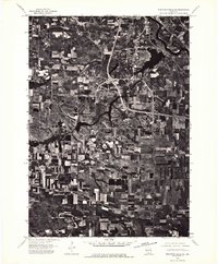
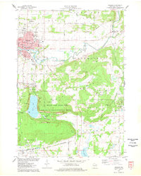
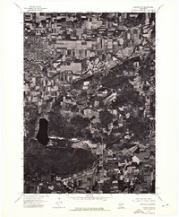 1974 Baraboo NW1976 Print · USGSThe city of Baraboo and the surrounding Wisconsin countryside are shown at the height of the 1970s through this aerial photographic survey. Researchers can trace the path of the Baraboo River or examine the shoreline of Devils Lake.
 - 1974 Map of Baraboo SW, 1976 Print
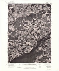
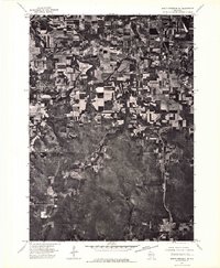
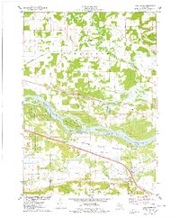
 1974 Baraboo SW1976 Print · USGSWisconsin riverfront life and mid-seventies agricultural patterns are frozen in time on this detailed orthophoto. Researchers can trace the street-level growth of Prairie Du Sac and the winding course of the Wisconsin River.
 - 1974 Map of Baraboo NE, 1976 Print
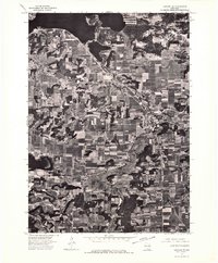
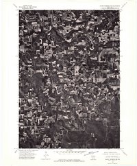
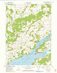
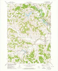
 1974 Baraboo NE1976 Print · USGSThe Wisconsin River valley comes into sharp focus in the mid-seventies, showing the rural landscape of Columbia County through detailed aerial photography. Local historians can trace the shoreline of Lake Wisconsin and the path of the Wisconsin River through a patchwork of family farms and wooded bluffs.
 - 1975 Map of Wisconsin Dells NW, 1976 Print
 1975 Wisconsin Dells NW1976 Print · USGSJuneau County farmland and rural infrastructure are captured in this mid-seventies aerial study of the central Wisconsin landscape. Genealogists and local historians can trace the precise 1975 footprint of Lyndon Station and the path of the Chicago Milwaukee St Paul and Pacific railroad.2 unique versions available
 - 1975 Map of Wisconsin Dells SE, 1976 Print
 1975 Wisconsin Dells SE1976 Print · USGSWisconsin Dells and the Sauk County countryside are documented in the mid-seventies just as the region’s modern footprint was taking shape. You can trace the exact 1975 shoreline of Lake Delton and see the early development of Wisconsin Dells along the Wisconsin River.3 unique versions available
 - 1975 Map of North Freedom NE, 1976 Print
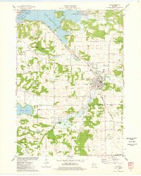
 1975 North Freedom NE1976 Print · USGSSauk County's rural heartland is visible in the mid-seventies, showing the agricultural patterns and small-town footprints of central Wisconsin. Researchers can trace the path of the Baraboo River as it passes near North Freedom and the growing outskirts of Baraboo.2 unique versions available
 - 1975 Map of North Freedom NW, 1976 Print
 1975 North Freedom NW1976 Print · USGSSauk County farmlands and river bends are captured in this mid-seventies aerial survey. Genealogists and researchers can trace the rural layouts of Rock Springs and La Rue or follow the path of the Baraboo River.2 unique versions available
 - 1975 Map of North Freedom SE, 1976 Print
 1975 North Freedom SE1976 Print · USGSSauk County’s agricultural and industrial landscape is captured in the mid-seventies in this detailed aerial survey. Researchers can trace land use patterns near Badger or locate the site of the Lodi Mill amidst the rolling farm acreage.2 unique versions available
 - 1975 Map of Wisconsin Dells NE, 1976 Print
 1975 Wisconsin Dells NE1976 Print · USGSThe northern reaches of the Dells region are captured in the mid-seventies, showing the vast Wisconsin River corridor and its surrounding agricultural plains. Genealogists and local historians can trace the rural landscape near Plainville and study original field patterns and timber stands from this period.2 unique versions available
 - 1975 Map of Wisconsin Dells SW, 1976 Print
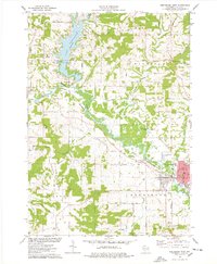
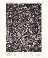 1975 Wisconsin Dells SW1976 Print · USGSSauk County's rural landscape is captured during the mid-seventies, showing the transition from town life to the surrounding highlands. Genealogists and historians can trace the growth of Reedsburg and the precise arrangement of local farmsteads.2 unique versions available
 - 1975 Map of North Freedom SW, 1976 Print
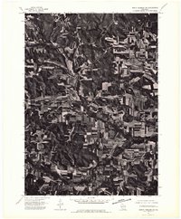 1975 North Freedom SW1976 Print · USGSSauk County's rural landscape is documented with aerial precision in the mid-1970s, showcasing the agricultural rhythm of the Driftless Area. Local historians can pinpoint the exact building layouts and field boundaries surrounding Leland, Black Hawk, and Witwen.2 unique versions available
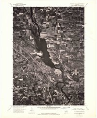
 - 1975 Map of Sauk City, 1978 Print
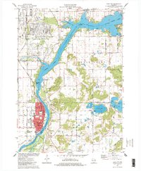 1975 Sauk City1978 Print · USGSThe Wisconsin River valley in the mid-seventies shows a landscape shaped by military industry and rail transport. Researchers can trace the massive Badger Army Ammunition Plant or locate the village of Merrimac near the Wiegands Bay shoreline.
 - 1975 Map of Pine Island, 1978 Print
 1975 Pine Island1978 Print · USGSThe Wisconsin River and its intricate sloughs define this rural landscape in the mid-seventies, just as the local wildlife areas were becoming established. Researchers can find old community anchors like Lewiston Sch, the Welsh Cem, and the path of the Chicago Milwaukee St Paul and Pacific railroad.
 - 1975 Map of Baraboo, 1978 Print
 1975 Baraboo1978 Print · USGSBaraboo and the surrounding driftless terrain are captured here in the mid-1970s, showing the city's growth alongside significant conservation lands. Genealogists and hikers can trace old family plots like Zuch Cem or explore the preserved topography of Devils Lake State Park and the Baraboo Range.2 unique versions available
 - 1975 Map of Lodi, 1978 Print
 1975 Lodi1978 Print · USGSLodi and the surrounding glacial valley are captured in the mid-seventies, showing a landscape defined by the railroad and the widening Wisconsin River. Researchers can trace family-named homesteads along Reynolds Road or locate historic burial sites like St Patricks Cem and Garden Bluff Cem.
 - 1975 Map of Durwards Glen, 1978 Print
 1975 Durwards Glen1978 Print · USGSColumbia County’s ridge-and-valley landscape is documented here in the mid-seventies, showing a mix of established family farms and riverfront growth. Genealogists can locate several historic burial grounds like St Johns Cem and Evangelical Cem alongside the Caledonia Sch.
 - 1975 Map of Wonewoc, 1978 Print
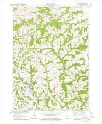 1975 Wonewoc1978 Print · USGSThe Baraboo River valley in the mid-1970s shows a landscape of ridge-top farms and river-bottom industry. Trace family roots at Pine Eden Cem or St Anns Cem, and locate landmarks like the Castle Rocks and Wonewoc village center.
 - 1975 Map of Lewiston, 1978 Print
 1975 Lewiston1978 Print · USGSThe Wisconsin River valley in the mid-1970s shows a landscape of small crossroads settlements and heavy rail infrastructure. Genealogists and local historians can trace family locations near Pecks Corners, the Fairfield Center Sch, and Hillcrest Cem.
 - 1975 Map of Reedsburg West, 1978 Print
 1975 Reedsburg West1978 Print · USGSSauk County's river valleys and the waters of Lake Redstone are captured here in the mid-seventies as the region balanced its rural roots with growing town centers. Genealogists and local historians can trace legacy sites like St Patricks Cemetery, Babb Cemetery, and the schools of Reedsburg.
 - 1975 Map of Potato Hill, 1978 Print
 1975 Potato Hill1978 Print · USGSIn the mid-1970s, the rural landscapes of Juneau and Sauk Counties were a network of ridge-top farms and valley creeks. Genealogists can locate family-named markers like Pollard Rock or trace ancestors at Evergreen Cem and St Paul Cem.
 - 1975 Map of La Valle, 1978 Print
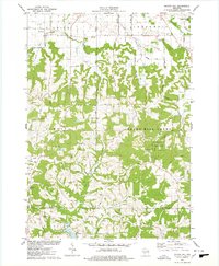
 1975 La Valle1978 Print · USGSThe Baraboo River valley in the mid-seventies shows a landscape of clustered hamlets and agricultural ridges along the Sauk and Richland county lines. Genealogists can trace family names through numerous rural burial sites like Simon Hill Cem and Norwegian Cem, or locate the mills and depots of La Valle and Ironton.
 - 1976 Map of La Crosse
 1976 La Crosse1976 Print · USGSThe Driftless Area and Mississippi River valley are captured here in the mid-seventies, showing a landscape of deep coulees and river commerce. Genealogists can trace family footprints from La Crosse to smaller hamlets like Newburg Corners and Witoka.
End of results
Showing maps 1-23 of 23
Top cities of Sauk County
- Baraboo historical maps
- Reedsburg historical maps
- Prairie du Sac historical maps
- Lake Delton historical maps
- Sauk City historical maps
- West Baraboo historical maps
See more
Frequently asked questions
- What are the different types of historical maps available for Sauk County?
- What is the oldest map of Sauk County?
- Where can I purchase historical maps of Sauk County for my home or office?
- Where can I download high-res historical maps of Sauk County?
- Are there historical topographic maps available for Sauk County?
- Is there historical aerial imagery available for Sauk County?
- Where are historical maps of Sauk County sourced from?