1940s Maps of Taylor County, Wisconsin
Explore 10 historic maps of Taylor County from the 1940s. These maps offer a rare glimpse into what life looked like during the 1940s — showing old roads, neighborhoods, homes, and landmarks that have changed or disappeared over time.
Whether you're researching your family's past, planning a metal detecting trip, or studying how Taylor County's landscape evolved across the 1940s, these high-resolution maps are a powerful tool for exploring the history of this region.
- Focus on a specific era: All maps on this page are from the 1940s, giving you a focused view of this time period.
- See what’s changed: Compare century-old streets, trails, and buildings to today's modern landscape using overlays and satellite layers.
- Research with precision: Use these maps for genealogy, historical research, land use analysis, or educational projects.
- View, download, or print: Maps are fully viewable online in high resolution, and can be downloaded or printed for your own records.
Start exploring Taylor County's history through authentic maps from the 1940s. This is your window into the past.
Taylor County, WI maps
(10)- 1944 Map of Ogema
 1944 Ogema1944 Print · USGSPrice County during the early 1940s was a landscape of remote farmsteads and timber interests centered on the rail corridor. Genealogists can trace family locations through a dense network of country schools like Forest Hill Sch and Larkin Sch, or the small siding at Mackeys Spur.
 - 1945 Map of Rib Lake
 1945 Rib Lake1945 Print · USGSNorthern Wisconsin lake country is captured here during the 1940s, showing a landscape of timber and township life. Genealogists can locate rural landmarks like Spirit Town Hall, Mission Ch, and schools like Ring Sch or Stone Lake Sch.
 - 1945 Map of Black River
 1945 Black River1945 Print · USGSNorthern Wisconsin's river systems and rural school districts are documented here just after the war years. Local historians can locate vanished landmarks like the Red Tile Sch, Meadow Creek Sch, and the early boundaries of the Chequamegon National Forest.
 - 1947 Map of Rib Lake, 1956 Print
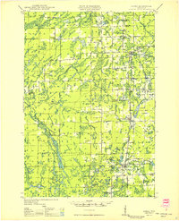
 1947 Rib Lake1956 Print · USGSTaylor and Price Counties come into focus during the late 1940s, a period when the timber industry and small-town life shaped this north-central Wisconsin landscape. Genealogists can trace family footprints through rural landmarks like Mission Ch, Stone Lake Sch, and the village of Rib Lake.
 - 1947 Map of Ogema, 1966 Print
 1947 Ogema1966 Print · USGSPrice and Taylor Counties are captured here just after the war, showing a rural landscape defined by logging, rail, and small lakeside settlements. Genealogists can trace family roots through numerous country schools like Centerville Sch and landmarks like Mt Olive Cem or Mackeys Spur.
 - 1947 Map of Sheldon, 1967 Print
 1947 Sheldon1967 Print · USGSRusk and Taylor counties come into focus in the late 1940s, showing a landscape of river-valley settlements and timber management. Genealogists and historians can locate dozens of country schools and churches, from Sheldon to the Mt Nebo Cem and Hannibal.
 - 1949 Map of Sheldon
 1949 Sheldon1949 Print · USGSRusk and Taylor counties come into focus during the late 1940s, showing a landscape defined by small rail towns and scattered district schools. You can locate family-named landmarks like Baughman School or trace the early paths of the Jump River and Main Creek.
 - 1949 Map of Ogema
 1949 Ogema1949 Print · USGSPrice and Taylor Counties are captured here in the late 1940s, showing the Northwoods before the modern era of highway expansion. Genealogists and local historians can trace many rural schoolhouses like Centerville School, church sites at Mt Olive Cemetery, and the Soo Line rail stops.
 - 1949 Map of Jump River Fire Tower
 1949 Jump River Fire Tower1949 Print · USGSThe dense forests and winding river forks of Price, Rusk, and Taylor counties are captured here in the years following World War II. Local historians can locate isolated rural landmarks like the Jump River Fire Tower, Red Tile Sch, and Lost Lake.
 - 1949 Map of Rib Lake
 1949 Rib Lake1949 Print · USGSRib Lake and the surrounding Northwoods townships appear here in the late 1940s, just as the rural schoolhouse system remained a central pillar of the community. Genealogists and historians can locate numerous local landmarks like Ring Sch, the Wilderness Lookout Tower, and the Mission Ch.
End of results
Showing maps 1-10 of 10
Top cities of Taylor County
- Medford historical maps
- Little Black historical maps
- Rib Lake historical maps
- Chelsea historical maps
- Westboro historical maps
- Stetsonville historical maps
See more
Frequently asked questions
- What are the different types of historical maps available for Taylor County?
- What is the oldest map of Taylor County?
- Where can I purchase historical maps of Taylor County for my home or office?
- Where can I download high-res historical maps of Taylor County?
- Are there historical topographic maps available for Taylor County?
- Is there historical aerial imagery available for Taylor County?
- Where are historical maps of Taylor County sourced from?