1980s Maps of Trempealeau County, Wisconsin
Explore 6 historic maps of Trempealeau County from the 1980s. These maps offer a rare glimpse into what life looked like during the 1980s — showing old roads, neighborhoods, homes, and landmarks that have changed or disappeared over time.
Whether you're researching your family's past, planning a metal detecting trip, or studying how Trempealeau County's landscape evolved across the 1980s, these high-resolution maps are a powerful tool for exploring the history of this region.
- Focus on a specific era: All maps on this page are from the 1980s, giving you a focused view of this time period.
- See what’s changed: Compare century-old streets, trails, and buildings to today's modern landscape using overlays and satellite layers.
- Research with precision: Use these maps for genealogy, historical research, land use analysis, or educational projects.
- View, download, or print: Maps are fully viewable online in high resolution, and can be downloaded or printed for your own records.
Start exploring Trempealeau County's history through authentic maps from the 1980s. This is your window into the past.
Trempealeau County, WI maps
(6)- 1984 Map of Blair
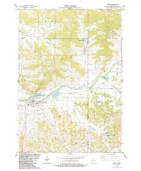 1984 Blair1984 Print · USGSThe coulee country of Trempealeau and Jackson Counties is captured here in the mid-1980s as the Trempealeau River flows through Blair. Genealogists and local historians can trace rural landmarks like Zion Cem, the Pine Hill Sch, and the Trump Coulee Cem.
 - 1984 Map of Osseo
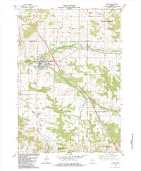 1984 Osseo1984 Print · USGSOsseo and the surrounding Wisconsin countryside are documented here in the mid-1980s as the regional hub for agricultural and river life. Genealogists and local historians can trace family locations near King Valley Ch, the South Valley Cem, and the small settlement of Requa.
 - 1984 Map of Pigeon Falls
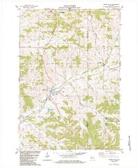 1984 Pigeon Falls1984 Print · USGSMid-1980s Trempealeau County comes alive in this survey of the coulee country surrounding the village of Pigeon Falls. Genealogists and local historians can trace family-named valleys like Hegge Coulee and locate rural landmarks such as Hale Cem and York.
 - 1984 Map of La Crosse, 1985 Print
 1984 La Crosse1985 Print · USGSThe Driftless Area of the upper Mississippi valley appears here in the mid-eighties, showing the tri-state intersections of Wisconsin, Minnesota, and Iowa. Genealogists and local historians can trace family-named landmarks such as Peacock Ridge or Prosch Coulee and locate rural landmarks like St Marys Ch.
 - 1985 Map of Eau Claire
 1985 Eau Claire1985 Print · USGSWestern Wisconsin's river valleys and growing mid-century cities are captured here in the mid-eighties. Genealogists and historians can trace the paths of the Chicago and North Western railroad and locate rural landmarks like Dells Millpond and Nine Mile Island.2 unique versions available
 - 1985 Map of Winona
 1985 Winona1985 Print · USGSThe Mississippi River valley and the coulees of the Driftless Area are shown here in the mid-1980s as the river's lock-and-dam system was well-established. Researchers can trace the riverfront at Winona, explore the bluffs near Galesville, or locate landmarks like Sugarloaf and Merrick State Park.2 unique versions available
End of results
Showing maps 1-6 of 6
Top cities of Trempealeau County
- Arcadia historical maps
- Osseo historical maps
- Whitehall historical maps
- Trempealeau historical maps
- Independence historical maps
- Galesville historical maps
See more
Frequently asked questions
- What are the different types of historical maps available for Trempealeau County?
- What is the oldest map of Trempealeau County?
- Where can I purchase historical maps of Trempealeau County for my home or office?
- Where can I download high-res historical maps of Trempealeau County?
- Are there historical topographic maps available for Trempealeau County?
- Is there historical aerial imagery available for Trempealeau County?
- Where are historical maps of Trempealeau County sourced from?