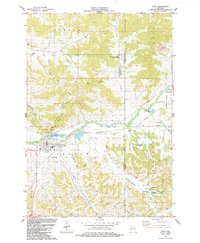
1984 Map of Blair
USGS Topo · Published 1984About this map
Blair sits at the confluence of several prominent drainages, including the Trempealeau River and Pigeon Creek. The landscape is defined by its coulee geography, with numerous narrow valleys like Skunk Hollow and Gransberg Hollow carving through the higher elevations of Shelley Ridge. This 1980s data highlights the established agricultural and conservation patterns of the region, featuring substantial managed lands such as the Vosse Coulee State Wildlife Area and the Trump Lake State Fishery Area. Local history is anchored by numerous rural sites including the Pine Hill Sch, Trempealeau Valley Ch, and several family and community burial grounds like Zion Cem and Cornelius Cem. The map provides a look at the local infrastructure of the era, from the Landing Strip south of town to the industrial footprints of the Industrial Waste Ponds and the municipal Sew Disp facility near Lake Henry.
Find a feature on this map
56 named features on this map. Tap any name to fly to it.
Don’t see what you’re looking for? This feature index may not catch every label — zoom into the map to look around manually.
Map Details
Editions of this 1984 Blair Map
This is the sole edition of this map. No revisions or reprints were ever made.
Other maps of this area

1926 · North Bend
USGS Topo · 1:62,500

1926 · Whitehall
USGS Topo · 1:62,500

1927 · Blair
USGS Topo · 1:62,500

1929 · Whitehall
USGS Topo · 1:62,500

1929 · Galesville
USGS Topo · 1:62,500

1929 · North Bend
USGS Topo · 1:62,500

1953 · Eau Claire
USGS Topo · 1:250,000

1958 · Eau Claire
USGS Topo · 1:250,000

1964 · Eau Claire
USGS Topo · 1:250,000
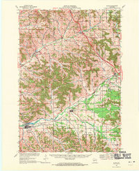
1968 · Blair
USGS Topo · 1:62,500