1970s Maps of Hale, Wisconsin
Explore 4 historic maps of Hale from the 1970s. These maps offer a rare glimpse into what life looked like during the 1970s — showing old roads, neighborhoods, homes, and landmarks that have changed or disappeared over time.
Whether you're researching your family's past, planning a metal detecting trip, or studying how Hale's landscape evolved across the 1970s, these high-resolution maps are a powerful tool for exploring the history of this region.
- Focus on a specific era: All maps on this page are from the 1970s, giving you a focused view of this time period.
- See what’s changed: Compare century-old streets, trails, and buildings to today's modern landscape using overlays and satellite layers.
- Research with precision: Use these maps for genealogy, historical research, land use analysis, or educational projects.
- View, download, or print: Maps are fully viewable online in high resolution, and can be downloaded or printed for your own records.
Start exploring Hale's history through authentic maps from the 1970s. This is your window into the past.
Hale, WI maps
(4)- 1973 Map of Strum SE, 1975 Print
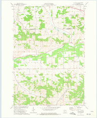 1973 Strum SE1975 Print · USGSTrempealeau County in the early seventies is shown here as a landscape of interconnected river valleys and rural townships. Researchers can trace the Chicago and North Western rail line and locate local landmarks like West Beef River Cem and Viking Airfield.
 - 1973 Map of Strum, 1975 Print
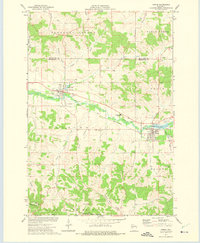 1973 Strum1975 Print · USGSTrempealeau County farm and rail life are centered here in the early seventies, as the river valley connects active village centers. Genealogists and historians can trace local landmarks like Hamlin Cem, the Central Area High Sch, and the winding Chicago and North Western rail line.
 - 1973 Map of Elk Creek, 1975 Print
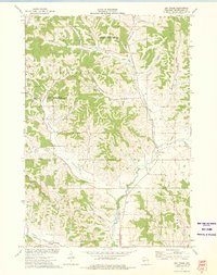 1973 Elk Creek1975 Print · USGSTrempealeau County's rural coulee country is captured in the early seventies, showing a landscape defined by deep valleys and high ridges. Researchers can locate family-named landmarks like Walek Knob and burial sites such as Chimney Rock Cem and Cripps Cem.
 - 1973 Map of Pleasantville, 1975 Print
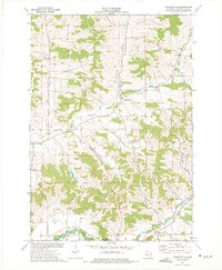 1973 Pleasantville1975 Print · USGSThe coulee country of Trempealeau County is captured here in the early seventies, showcasing a rural landscape of valley farms and ridge-top quarries. Researchers can locate family landmarks like the Wagner Cem, Elk Creek Ch, and the small settlement of Coral City.
End of results
Showing maps 1-4 of 4
Top cities near Hale
- Arcadia historical maps
- Pleasant Valley historical maps
- Osseo historical maps
- Whitehall historical maps
- Independence historical maps
- Augusta historical maps
See more
Top neighborhoods of Hale
Frequently asked questions
- What are the different types of historical maps available for Hale?
- What is the oldest map of Hale?
- Where can I purchase historical maps of Hale for my home or office?
- Where can I download high-res historical maps of Hale?
- Are there historical topographic maps available for Hale?
- Is there historical aerial imagery available for Hale?
- Where are historical maps of Hale sourced from?