1970s Maps of Little Wolf, Wisconsin
Explore 2 historic maps of Little Wolf from the 1970s. These maps offer a rare glimpse into what life looked like during the 1970s — showing old roads, neighborhoods, homes, and landmarks that have changed or disappeared over time.
Whether you're researching your family's past, planning a metal detecting trip, or studying how Little Wolf's landscape evolved across the 1970s, these high-resolution maps are a powerful tool for exploring the history of this region.
- Focus on a specific era: All maps on this page are from the 1970s, giving you a focused view of this time period.
- See what’s changed: Compare century-old streets, trails, and buildings to today's modern landscape using overlays and satellite layers.
- Research with precision: Use these maps for genealogy, historical research, land use analysis, or educational projects.
- View, download, or print: Maps are fully viewable online in high resolution, and can be downloaded or printed for your own records.
Start exploring Little Wolf's history through authentic maps from the 1970s. This is your window into the past.
Little Wolf, WI maps
(2)- 1970 Map of Symco, 1973 Print
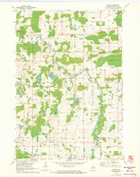 1970 Symco1973 Print · USGSWaupaca County's glacial landscape is meticulously documented here during the early 1970s, as the Little Wolf River carves through a region of scattered dairy farms and woodlots. Researchers can locate early family landmarks like St Pauls Ch and the Danish Cem or trace the drainage of Marble Swamp.
 - 1970 Map of Clintonville South, 1973 Print
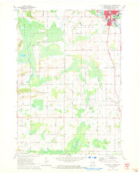 1970 Clintonville South1973 Print · USGSWaupaca County's rural townships and the southern edge of Clintonville are documented here in the early 1970s. Trace family land near Marble Cem, find local landmarks like St Martin Sch, and follow the old CHICAGO AND NORTH WESTERN rail line.
End of results
Showing maps 1-2 of 2
Top cities near Little Wolf
- New London historical maps
- Waupaca historical maps
- Clintonville historical maps
- Dale historical maps
- Belle Plaine historical maps
- Weyauwega historical maps
See more
Frequently asked questions
- What are the different types of historical maps available for Little Wolf?
- What is the oldest map of Little Wolf?
- Where can I purchase historical maps of Little Wolf for my home or office?
- Where can I download high-res historical maps of Little Wolf?
- Are there historical topographic maps available for Little Wolf?
- Is there historical aerial imagery available for Little Wolf?
- Where are historical maps of Little Wolf sourced from?