1960s Maps of Scandinavia, Wisconsin
Explore 2 historic maps of Scandinavia from the 1960s. These maps offer a rare glimpse into what life looked like during the 1960s — showing old roads, neighborhoods, homes, and landmarks that have changed or disappeared over time.
Whether you're researching your family's past, planning a metal detecting trip, or studying how Scandinavia's landscape evolved across the 1960s, these high-resolution maps are a powerful tool for exploring the history of this region.
- Focus on a specific era: All maps on this page are from the 1960s, giving you a focused view of this time period.
- See what’s changed: Compare century-old streets, trails, and buildings to today's modern landscape using overlays and satellite layers.
- Research with precision: Use these maps for genealogy, historical research, land use analysis, or educational projects.
- View, download, or print: Maps are fully viewable online in high resolution, and can be downloaded or printed for your own records.
Start exploring Scandinavia's history through authentic maps from the 1960s. This is your window into the past.
Scandinavia, WI maps
(2)- 1969 Map of Ogdensburg, 1972 Print
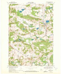
 1969 Ogdensburg1972 Print · USGSOgdensburg and the surrounding Waupaca County countryside are captured here in the late sixties, showcasing a landscape of glacial lakes and rural industry. Genealogists and local historians can locate the Ogdensburg Cemetery, trace the Green Bay and Western railroad, and identify early extractive sites like the Quarry.
 - 1969 Map of Scandinavia, 1972 Print
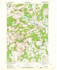
 1969 Scandinavia1972 Print · USGSScandinavia and its surrounding glacial lake country are captured in the late sixties as the village remained a rail-and-river hub. Genealogists can locate family-named sites like Bestul and Petersen alongside historical grounds at Salem Cem and Farmington Cem.2 unique versions available
End of results
Showing maps 1-2 of 2
Top cities near Scandinavia
- Waupaca historical maps
- Stockton historical maps
- Weyauwega historical maps
- Iola historical maps
- Amherst historical maps
- Alban historical maps
See more
Frequently asked questions
- What are the different types of historical maps available for Scandinavia?
- What is the oldest map of Scandinavia?
- Where can I purchase historical maps of Scandinavia for my home or office?
- Where can I download high-res historical maps of Scandinavia?
- Are there historical topographic maps available for Scandinavia?
- Is there historical aerial imagery available for Scandinavia?
- Where are historical maps of Scandinavia sourced from?