1990s Maps of Scandinavia, Wisconsin
Explore 2 historic maps of Scandinavia from the 1990s. These maps offer a rare glimpse into what life looked like during the 1990s — showing old roads, neighborhoods, homes, and landmarks that have changed or disappeared over time.
Whether you're researching your family's past, planning a metal detecting trip, or studying how Scandinavia's landscape evolved across the 1990s, these high-resolution maps are a powerful tool for exploring the history of this region.
- Focus on a specific era: All maps on this page are from the 1990s, giving you a focused view of this time period.
- See what’s changed: Compare century-old streets, trails, and buildings to today's modern landscape using overlays and satellite layers.
- Research with precision: Use these maps for genealogy, historical research, land use analysis, or educational projects.
- View, download, or print: Maps are fully viewable online in high resolution, and can be downloaded or printed for your own records.
Start exploring Scandinavia's history through authentic maps from the 1990s. This is your window into the past.
Scandinavia, WI maps
(2)- 1992 Map of Ogdensburg, 1995 Print
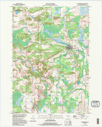 1992 Ogdensburg1995 Print · USGSCentral Wisconsin at the dawn of the nineties shows a landscape of glacial lakes and quiet river valleys. Genealogists can trace family footprints near Ogdensburg via Iola Cem, Ogdensburg Cem, and the timbered slopes of Poverty Hill.
 - 1992 Map of Big Falls, 1996 Print
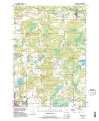 1992 Big Falls1996 Print · USGSWaupaca County in the 1990s reveals a landscape of glacial lakes and river-borne history. Researchers can trace the Old RR Grade through Big Falls or locate family landmarks near Schmidt Corner and Goodhal Lake.
End of results
Showing maps 1-2 of 2
Top cities near Scandinavia
- Waupaca historical maps
- Stockton historical maps
- Weyauwega historical maps
- Iola historical maps
- Amherst historical maps
- Alban historical maps
See more
Frequently asked questions
- What are the different types of historical maps available for Scandinavia?
- What is the oldest map of Scandinavia?
- Where can I purchase historical maps of Scandinavia for my home or office?
- Where can I download high-res historical maps of Scandinavia?
- Are there historical topographic maps available for Scandinavia?
- Is there historical aerial imagery available for Scandinavia?
- Where are historical maps of Scandinavia sourced from?