1960s Maps of Waupaca, Wisconsin
Explore 4 historic maps of Waupaca from the 1960s. These maps offer a rare glimpse into what life looked like during the 1960s — showing old roads, neighborhoods, homes, and landmarks that have changed or disappeared over time.
Whether you're researching your family's past, planning a metal detecting trip, or studying how Waupaca's landscape evolved across the 1960s, these high-resolution maps are a powerful tool for exploring the history of this region.
- Focus on a specific era: All maps on this page are from the 1960s, giving you a focused view of this time period.
- See what’s changed: Compare century-old streets, trails, and buildings to today's modern landscape using overlays and satellite layers.
- Research with precision: Use these maps for genealogy, historical research, land use analysis, or educational projects.
- View, download, or print: Maps are fully viewable online in high resolution, and can be downloaded or printed for your own records.
Start exploring Waupaca's history through authentic maps from the 1960s. This is your window into the past.
Waupaca, WI maps
(4)- 1969 Map of Manawa, 1971 Print
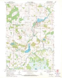 1969 Manawa1971 Print · USGSWaupaca County's rural heartland is captured here in the late sixties as the river-and-rail economy defined local life. Researchers can trace family-named roads and find quiet landmarks like St John Ch, Baldwins Mill Cem, and Green Valley Sch.2 unique versions available
 - 1969 Map of Weyauwega, 1971 Print
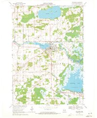 1969 Weyauwega1971 Print · USGSWeyauwega and the surrounding Waupaca County countryside are captured here in the late sixties as the river-and-rail economy remained central to the region. Researchers can trace family-named sites like Butternut Ridge, find local landmarks like the Waupaca County Fairground, and locate cemeteries including Oakwood Cemetery and Hobart Cem.2 unique versions available
 - 1969 Map of Waupaca, 1972 Print
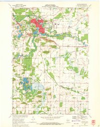 1969 Waupaca1972 Print · USGSWaupaca and its surrounding townships are captured in the late sixties as the area balanced its river-based industry with growing recreational lakefronts. Genealogists and local researchers can locate St Mary Magdalene Cem, the settlement of Little Hope, and the path of the Soo Line railroad.
 - 1969 Map of Ogdensburg, 1972 Print
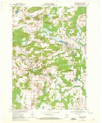 1969 Ogdensburg1972 Print · USGSOgdensburg and the surrounding Waupaca County countryside are captured here in the late sixties, showcasing a landscape of glacial lakes and rural industry. Genealogists and local historians can locate the Ogdensburg Cemetery, trace the Green Bay and Western railroad, and identify early extractive sites like the Quarry.
End of results
Showing maps 1-4 of 4
Top cities near Waupaca
- Waupaca historical maps
- Weyauwega historical maps
- Manawa historical maps
- Iola historical maps
- Alban historical maps
- Wild Rose historical maps
See more
Frequently asked questions
- What are the different types of historical maps available for Waupaca?
- What is the oldest map of Waupaca?
- Where can I purchase historical maps of Waupaca for my home or office?
- Where can I download high-res historical maps of Waupaca?
- Are there historical topographic maps available for Waupaca?
- Is there historical aerial imagery available for Waupaca?
- Where are historical maps of Waupaca sourced from?