1950s Maps of Waushara County, Wisconsin
Explore 5 historic maps of Waushara County from the 1950s. These maps offer a rare glimpse into what life looked like during the 1950s — showing old roads, neighborhoods, homes, and landmarks that have changed or disappeared over time.
Whether you're researching your family's past, planning a metal detecting trip, or studying how Waushara County's landscape evolved across the 1950s, these high-resolution maps are a powerful tool for exploring the history of this region.
- Focus on a specific era: All maps on this page are from the 1950s, giving you a focused view of this time period.
- See what’s changed: Compare century-old streets, trails, and buildings to today's modern landscape using overlays and satellite layers.
- Research with precision: Use these maps for genealogy, historical research, land use analysis, or educational projects.
- View, download, or print: Maps are fully viewable online in high resolution, and can be downloaded or printed for your own records.
Start exploring Waushara County's history through authentic maps from the 1950s. This is your window into the past.
Waushara County, WI maps
(5)- 1955 Map of Green Bay, 1968 Print
 1955 Green Bay1968 Print · USGSCentral and Eastern Wisconsin are captured here in the mid-fifties, showing the industrial growth of the Fox Valley and Wisconsin River corridors. Genealogists and historians can trace rail lines like the Green Bay and Western through settlements like Weyauwega, Clintonville, and Pulaski.2 unique versions available
 - 1956 Map of Ripon, 1957 Print
 1956 Ripon1957 Print · USGSRipon and the surrounding Wisconsin lakelands are shown in the mid-fifties as the region's rail and agricultural patterns remained firmly intact. Researchers can locate numerous rural schoolhouses like Prairie Lawn Sch and trace the legacy of Ripon College or the historic settlement of Sacramento.
 - 1957 Map of Madison, 1967 Print
 1957 Madison1967 Print · USGSSouth-central Wisconsin in the mid-fifties reveals a landscape of industrial hubs and glacial lakes linked by a dense rail and highway network. Genealogists and historians can trace the development of lakeside communities and find notable sites like Badger Ordnance Works and the Horicon National Wildlife Refuge.3 unique versions available
 - 1958 Map of Coloma, 1960 Print
 1958 Coloma1960 Print · USGSThe Central Wisconsin sand plains are shown during the late 1950s as small towns like Plainfield and Coloma flourished along the Chicago and North Western rail line. Genealogists can locate rural schoolhouses such as Rathermel Sch and family landmarks like Owens Rock.
 - 1959 Map of Wautoma, 1961 Print
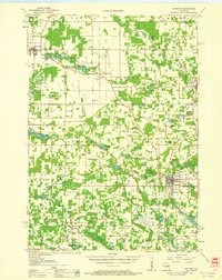 1959 Wautoma1961 Print · USGSWaushara County in the late fifties shows a rural landscape defined by glacial lakes and a developing transportation network. Genealogists can trace family names through numerous sites like Richford Cem, West Holden Ch, and St Pauls Cem.
End of results
Showing maps 1-5 of 5
Top cities of Waushara County
- Wautoma historical maps
- Redgranite historical maps
- Wild Rose historical maps
- Plainfield historical maps
- Coloma historical maps
- Hancock historical maps
See more
Frequently asked questions
- What are the different types of historical maps available for Waushara County?
- What is the oldest map of Waushara County?
- Where can I purchase historical maps of Waushara County for my home or office?
- Where can I download high-res historical maps of Waushara County?
- Are there historical topographic maps available for Waushara County?
- Is there historical aerial imagery available for Waushara County?
- Where are historical maps of Waushara County sourced from?