1980s Maps of Waushara County, Wisconsin
Explore 9 historic maps of Waushara County from the 1980s. These maps offer a rare glimpse into what life looked like during the 1980s — showing old roads, neighborhoods, homes, and landmarks that have changed or disappeared over time.
Whether you're researching your family's past, planning a metal detecting trip, or studying how Waushara County's landscape evolved across the 1980s, these high-resolution maps are a powerful tool for exploring the history of this region.
- Focus on a specific era: All maps on this page are from the 1980s, giving you a focused view of this time period.
- See what’s changed: Compare century-old streets, trails, and buildings to today's modern landscape using overlays and satellite layers.
- Research with precision: Use these maps for genealogy, historical research, land use analysis, or educational projects.
- View, download, or print: Maps are fully viewable online in high resolution, and can be downloaded or printed for your own records.
Start exploring Waushara County's history through authentic maps from the 1980s. This is your window into the past.
Waushara County, WI maps
(9)- 1980 Map of Fond Du Lac
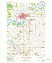
 1980 Fond Du Lac1980 Print · USGSThe Fox River Valley and Horicon Marsh meet here during the late twentieth century, showing a transition from lakeside industry to glacial conservation. Genealogists can locate family sites at Estabrook Cem or trace the rail lines through Ripon and Waupun.
 - 1980 Map of Berlin, 1981 Print
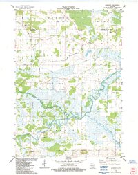
 1980 Berlin1981 Print · USGSThe Fox River valley in Green Lake County appears here during the early eighties, centered on the historic city of Berlin. Researchers can trace family sites among several country churches and cemeteries, including St Stanislaus Cem, or locate rural schools like Lamberton Sch.
 - 1984 Map of Fairburn
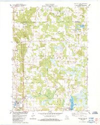
 1984 Fairburn1984 Print · USGSCentral Wisconsin wetlands define this mid-1980s landscape at the confluence of the Fox River and White River. Genealogists and historians can locate the Fairburn Cem, the settlement of Fairburn, and the heights of Mt Tom.
 - 1984 Map of Westfield East
 1984 Westfield East1984 Print · USGSMarquette County in the early eighties shows a landscape of winding glacial creeks and established rural villages like Westfield and Harrisville. Researchers can trace local heritage through numerous burial sites like Krentz Cem or explore the drainage of Chaffee Creek and Harris Pond.
 - 1984 Map of Neshkoro
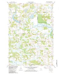 1984 Neshkoro1984 Print · USGSThe confluence of the White River and Mecan River in the mid-1980s reveals a landscape of working mills and protected wetlands. Trace local family history through sites like Bannerman, St Peter Cem, and the village of Neshkoro.
 - 1984 Map of Germania
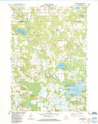 1984 Germania1984 Print · USGSThe borderlands of Marquette and Waushara Counties in the 1980s reveal a landscape of deep marshes and small rural hamlets. Local historians can trace the foundations of the community at Germania, locate the St Johns Ch Cem, and explore the wetlands of the Germania Marsh State Wildlife Area.
 - 1984 Map of Appleton, 1985 Print
 1984 Appleton1985 Print · USGSThe Fox River Valley in the mid-eighties shows a bustling corridor of industry and nature, from the shores of Lake Winnebago to the Oneida Indian Reservation. Trace local heritage through landmarks like Riverside Cem or explore the wetlands of Poygan Marsh State Wildlife Area.2 unique versions available
 - 1985 Map of Wisconsin Dells
 1985 Wisconsin Dells1985 Print · USGSCentral Wisconsin in the mid-eighties was a landscape of intricate river bends, rail junctions, and sprawling marshlands. Researchers can trace historic routes along the Soo Line or locate family landmarks near Lyndon Station, Buffalo Lake, and Puckaway Lake.
 - 1985 Map of Wisconsin Rapids
 1985 Wisconsin Rapids1985 Print · USGSCentral Wisconsin in the mid-eighties shows a landscape of engineered waterways and active rail corridors between Wisconsin Rapids and Waupaca. Genealogists and researchers can trace local landmarks like Roche A Cri State Park, the SOO LINE, and small settlements like Coddington or Rudolph.2 unique versions available
End of results
Showing maps 1-9 of 9
Top cities of Waushara County
- Wautoma historical maps
- Redgranite historical maps
- Wild Rose historical maps
- Plainfield historical maps
- Coloma historical maps
- Hancock historical maps
See more
Frequently asked questions
- What are the different types of historical maps available for Waushara County?
- What is the oldest map of Waushara County?
- Where can I purchase historical maps of Waushara County for my home or office?
- Where can I download high-res historical maps of Waushara County?
- Are there historical topographic maps available for Waushara County?
- Is there historical aerial imagery available for Waushara County?
- Where are historical maps of Waushara County sourced from?